Category:Works of Philip John Bainbrigge
Media in category "Works of Philip John Bainbrigge"
The following 166 files are in this category, out of 166 total.
-
 A Bush Road, Upper Canada.jpg 342 × 480; 62 KB
-
 A Clearing, Upper Canada.jpg 640 × 544; 120 KB
-
 A Large Raft on the St. Lawrence River.jpg 640 × 443; 70 KB
-
 Appearance of the Cone at Montmorency, January 14, 1837.jpg 337 × 480; 45 KB
-
 Artillery Returning to Montreal, 1841.jpg 640 × 423; 57 KB
-
 Barracks at Chatham, Upper Canada, ca. 1838.jpg 640 × 455; 104 KB
-
 Barracks at Upper Chatham, Upper Canada, 1838.jpg 640 × 463; 99 KB
-

-
 Beloeil Mountain and St. Hilaire.jpg 640 × 457; 68 KB
-
 Block House at the Meeting of the Madawaska and St. Johns Rivers.jpg 986 × 645; 281 KB
-
 Block House, Junction of Madawaska and St. John s Rivers.jpg 960 × 561; 122 KB
-
 Brock's Monument, Queenston Heights.jpg 640 × 482; 65 KB
-
 Brocks Monument.jpg 640 × 447; 71 KB
-
 Brockville, September 1840.jpg 640 × 436; 53 KB
-
 Bush Farm Near Chatham, ca. 1838.jpg 760 × 468; 115 KB
-
 Button Wood Tree, 18 ft. in circumference, in the bush near Chatham.jpg 760 × 640; 122 KB
-
 Camp St. Francois, Centre of Temiscouata Portage.jpg 640 × 463; 102 KB
-
 Canterskill Falls, Catskill Mountains, and Rip Van Winkle Rock.jpg 334 × 480; 41 KB
-
 Cape Diamond, Point Levi and the Citadel of Quebec from Wolfe s Cove.jpg 760 × 535; 106 KB
-
 Cascade, River St. Lawrence.jpg 640 × 482; 85 KB
-
 Cedars Rapid, St. Lawrence, 1840.jpg 640 × 470; 89 KB
-
 Champs-de-Mars, Montreal.jpg 476 × 580; 54 KB
-
 Charlebourg and the St. Charles River, October 28, 1836.jpg 640 × 447; 120 KB
-
 Chats Rapids, near Ottawa.jpg 334 × 480; 47 KB
-
 Chaudiere Falls .jpg 640 × 437; 94 KB
-
 Chaudiere Falls, Ottawa, from the Bytown Banks.jpg 640 × 451; 82 KB
-
 Chaudiere Falls..jpg 640 × 463; 103 KB
-
 Chaudiere Falls.jpg 640 × 401; 65 KB
-
 Citadel and Ramparts, Quebec.jpg 640 × 430; 75 KB
-
 Cobourg, Lake Ontario.jpg 640 × 444; 80 KB
-
 Creuse River, Ottawa.jpg 640 × 383; 52 KB
-
 Crossing Lake Etchemin on the Ice, Dec. 12, 1836.jpg 747 × 511; 90 KB
-
 Eglise Bon Secours, Montreal, 1841.jpg 485 × 596; 117 KB
-
 Entrance to Rideau Canal, Bytown, ca. 1838.jpg 640 × 459; 93 KB
-
 Falls of Montmorency from Below, July 1836.jpg 350 × 480; 52 KB
-
 Falls of Montmorency, near Quebec, 1836.jpg 640 × 439; 86 KB
-
 Fort and Pier, Toronto.jpg 640 × 453; 53 KB
-
 Fort Niagara from Fort Mississauga, Upper Canada.jpg 760 × 537; 117 KB
-
 Fort Ticonderoga, Lake George.jpg 640 × 445; 58 KB
-
 Fort William Henry , Lake George.jpg 640 × 419; 83 KB
-
 Fort William Henry, Lake George.jpg 640 × 451; 67 KB
-
 Fort York in 1839...CAN 2836347 c002801k.jpg 2,000 × 1,415; 337 KB
-
 Fort York in 1839...CAN 2836347 c002801k.webp 640 × 453; 35 KB
-
 Forts Henry and Frederick from Kingston, July 1838.jpg 640 × 430; 52 KB
-
 From a Rock at the Upper End of Lake Charles.jpg 640 × 409; 66 KB
-
 From angle of Horse shoe Fall near the Tower, 1839.jpg 371 × 480; 57 KB
-
 From Beloeil Mountain, Lake - Yamaska - Rougemont.jpg 640 × 481; 78 KB
-
 HBC canoes at Chats Falls.jpg 640 × 440; 77 KB
-
 Horseshoe Fall from Niagara, from Goat Island.jpg 640 × 445; 78 KB
-
 Horseshoe Falls .jpg 640 × 445; 60 KB
-
 Horseshoe Falls, from Goat Island.jpg 640 × 456; 74 KB
-
 Horseshoe Falls, Niagara .jpg 640 × 440; 81 KB
-
 Horseshoe Falls, Niagara.jpg 640 × 454; 74 KB
-
 Ice Boat at Penetanguishene, Lake Huron.jpg 1,280 × 862; 173 KB
-
 Ice near Guards Barracks, Montreal 1840.jpg 640 × 439; 89 KB
-
 Ice Shove at Montreal.jpg 800 × 567; 99 KB
-
 Indians Poling up the Rapids of the St. Lawrence, ca. 1839.jpg 640 × 450; 73 KB
-
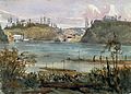
 Isle of St. Helens from Montreal, ca. 1836.jpg 640 × 438; 68 KB
-
 Jones Falls, Rideau Canal, Upper Canada.jpg 760 × 544; 95 KB
-
 Junction of Madawaska and St. Johns Rivers.jpg 640 × 410; 69 KB
-
 Kingston Mills 1841.jpg 640 × 439; 78 KB
-
 La Chapelles Bridge, Montreal.jpg 640 × 452; 163 KB
-

-
 Lake Erie.jpg 640 × 447; 74 KB
-
 Lake George from Top of Black Mountain.jpg 640 × 443; 55 KB
-
 Lake George, New York.jpg 640 × 440; 72 KB
-
 Landscape with River and Bridge - Bainbridge.jpg 640 × 447; 76 KB
-

-
 Long Island - Dam and Locks, Rideau Canal, Upper Canada, Ottawa.jpg 640 × 421; 58 KB
-
 Lower Bytown.jpg 640 × 442; 80 KB
-
 Maisons transitoires sur la route entre Montreal et La Prairie.jpg 794 × 469; 70 KB
-
 Making Maple Sugar, Lower Canada, 1837.jpg 760 × 558; 108 KB
-
 Merrickville, Rideau River.jpg 640 × 454; 77 KB
-

-
 Montmorency and Isle of Orleans from a hill below Point Levi.jpg 640 × 459; 79 KB
-

-
 Montreal and St. Helen's Isle from the Mountain, 1838.jpg 640 × 254; 51 KB
-
 Montreal and St. Helen's Isle, 1837.jpg 640 × 390; 47 KB
-
 Montreal and St. Helen's Isle, 1838.jpg 640 × 411; 66 KB
-
 Montreal from Cote-des-Neiges.jpg 800 × 570; 88 KB
-
 Montreal from Longueuil.jpg 640 × 518; 85 KB
-
 Montreal from the Hill, Behind the Village Of The Tanneries On the Road to Lachine.jpg 3,170 × 2,133; 1.72 MB
-
 Montreal from the west.jpg 640 × 439; 114 KB
-
 Montreal in the Winter of 1841 Showing an Ice Shove.jpg 760 × 532; 94 KB
-
 Montreal Mount and Beloeil from Nuns Island, 1841.jpg 640 × 422; 61 KB
-
 Montreal Mountain from my Window.jpg 295 × 251; 18 KB
-
 Montreal seen from the road to Quebec.jpg 747 × 471; 149 KB
-

-
 Mr. Johnson's Bush Farm and Major Fuch's Cottage near Quebec.jpg 640 × 422; 82 KB
-
 Narrows at Lake Charles.jpg 640 × 478; 93 KB
-
 Near St. Andre, St. Lawrence.jpg 640 × 390; 54 KB
-
 Near the Turcots, Latimer Road near St Feriole.jpg 640 × 452; 80 KB
-
 Niagara Falls from the American Side.jpg 640 × 501; 98 KB
-
 Niagara from the Table Rock, 1838.jpg 640 × 472; 71 KB
-
 Niagara River from Queenston Heights.jpg 640 × 440; 71 KB
-
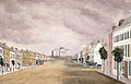 Pennsylvania Avenue, Washington.jpg 640 × 412; 60 KB
-
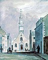 Philip John Bainbrigge, Bon Secours Church, Montreal, 1841.jpg 387 × 480; 79 KB
-
 Pier and Fort, Toronto, 1839.jpg 1,000 × 645; 83 KB
-
-
 Point Olivier, Beloeil Mountain, and the Chambly Basin.jpg 640 × 437; 71 KB
-
 Portage along the Ottawa River.jpg 328 × 480; 44 KB
-
 Portage of the Riviere Cachee, St. Maurice.jpg 640 × 467; 104 KB
-
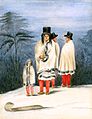
 Portrait of Canadian Indian Christine Vincent by Philip Bainbrigge.jpg 574 × 746; 140 KB
-
 Portrait of Canadian Indian Nicolas Vincent by Philip J. Bainbrigge.jpg 580 × 754; 134 KB
-

-
-
 Protestant and Catholic Churches in Montreal from near Mr. Molson s.png 1,625 × 1,115; 3.35 MB
-
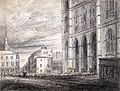
 Quebec and Mouth of the St. Charles River from Point Levi.jpg 760 × 524; 85 KB
-
 Quebec en 1836 - P.J. Bainbridge.jpg 960 × 678; 128 KB
-
 Quebec from Charlesbourg.jpg 640 × 443; 82 KB
-
 Quebec from Point Levi - Bainbrigge.jpg 578 × 400; 111 KB
-
 Quebec from Point Levi.jpg 698 × 518; 127 KB
-
 Quebec from St. Charles River, c. 1837-1838.jpg 1,890 × 1,550; 366 KB
-
 Quebec from the Chaudiere Bridge.jpg 640 × 394; 77 KB
-
 Quebec from the Citadel - Millicent Mary Chaplin.jpg 3,200 × 1,265; 1.03 MB
-
 Quebec from the Citadel.jpg 759 × 268; 115 KB
-
 Rapid and Fort - Coteau du Lac, 1840.jpg 640 × 421; 80 KB
-
 Rapids above the Falls, St. Lawrence River.jpg 640 × 448; 92 KB
-

-
 Rapids on the Ottawa River above Iron Decharge.jpg 640 × 451; 66 KB
-
 Red Granite Rocks and Glacier near Lake Nipissing.jpg 640 × 444; 70 KB
-
 River Montmorency, August 1837.jpg 640 × 440; 62 KB
-
 Road Broken up by Ice, Rue de l eau, Montreal.jpg 640 × 412; 66 KB
-
 Rochester Bridge, Pontoons.jpg 640 × 374; 52 KB
-
 Rough Sketch of Montreal, 1837.jpg 640 × 465; 94 KB
-
 Ruins of Fort Erie and City of Buffalo, 1838.jpg 640 × 444; 68 KB
-

-
 Ruins of St. Eustache, Lower Canada.jpg 640 × 443; 78 KB
-

-
 Scout Hill and Fort William Henry, Lake George.jpg 640 × 439; 82 KB
-
 Shad Fishery, Sault au Cochon, St. Lawrence River.jpg 640 × 474; 71 KB
-
 Shawinigan Falls, St. Maurice River.jpg 640 × 469; 93 KB
-
 Sketch of the River St. Charles from above St. John s Gate.jpg 1,280 × 900; 223 KB
-
 St. Lawrence River from Diamond Bastion, Citadel at Quebec City.jpg 331 × 480; 35 KB
-

-
 St. Paul's Bay, St. Lawrence River.jpg 640 × 491; 123 KB
-
 Study of Sky, View near Montreal.jpg 640 × 417; 44 KB
-
 Talon Fall and Red Granite rocks near Lake Nipissing, 1838.jpg 640 × 438; 90 KB
-
 The Chaudiere Falls from the Bridge House, Ottawa.jpg 640 × 457; 112 KB
-
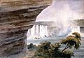
 The Cleft of the Chaudiere Falls.jpg 640 × 452; 74 KB
-
 The Horicans on Lake George.jpg 640 × 454; 55 KB
-
 The Opening of the Highlands on the Hudson River from Sing-Sing.jpg 640 × 450; 70 KB
-
 The Plains of Abraham, ca. 1836.jpg 640 × 475; 89 KB
-
 The spot where Wolfe ascended the Heights of Abraham.jpg 640 × 577; 170 KB
-
 The St. Lawrence River, ca. 1838.jpg 640 × 463; 54 KB
-
 The Terrace, Quebec City. Monument to Wolfe and Montcalm.jpg 964 × 663; 261 KB
-
 Timber Slide on the Ottawa River, Chats Falls.jpg 640 × 440; 62 KB
-
 Upper End of Lake Charles.jpg 640 × 444; 54 KB
-
 Upper Lake Charles.jpg 640 × 451; 64 KB
-
 View from my Window, Quebec, Lower Canada.jpg 640 × 458; 68 KB
-
 View near Cap Rouge on the River St. Lawrence, 1841.jpg 640 × 450; 97 KB
-
 View of Amherstburg, Upper Canada.jpg 640 × 434; 80 KB
-

-
 View of Fort and Chambly Church.jpg 760 × 542; 114 KB
-
 View of Lake Charles from the South.jpg 640 × 439; 61 KB
-
 View of Niagara Falls from above.jpg 640 × 460; 81 KB
-
 View of Quebec from the Command Engineer s House.jpg 640 × 539; 103 KB
-

-
 View of Sing Sing on the Hudson.jpg 640 × 459; 69 KB
-
 View of Sorel.jpg 640 × 455; 69 KB
-
 View of St. Denis.jpg 640 × 457; 78 KB
-

-
 Water landscape - Bainbridge.jpg 640 × 437; 72 KB
-
 Watermill with Horizontal Wheel, Ticonderoga.jpg 330 × 480; 30 KB
-
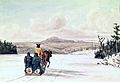
 Winter Travelling in Lower Canada.jpg 640 × 457; 67 KB
-
 Wolfe s Cove from the French Works, 1838.jpg 640 × 449; 155 KB


