Category:Ziegelei Parey
|
Ziegelei Parey has an entry on OpenStreetMap (show). |
Structure in Parey (Elbe)  | |||||
| Upload media | |||||
| Instance of | |||||
|---|---|---|---|---|---|
| Location |
| ||||
| Connects with | |||||
| Heritage designation | |||||
| Inception |
| ||||
| Date of official closure |
| ||||
 | |||||
This is the category of the Saxony-Anhalt Kulturdenkmal (cultural heritage monument) with the ID 09486853 (Wikidata)
|
Subcategories
This category has the following 4 subcategories, out of 4 total.
B
- Bahndamm Ziegelei Parey (6 F)
H
- Hafen Ziegelei Parey (9 F)
P
- Photovoltaik Ziegelei Parey (3 F)
T
- Trafo Ziegelei (6 F)
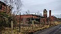
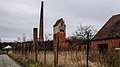
Media in category "Ziegelei Parey"
The following 18 files are in this category, out of 18 total.
-
 A. Seeger - Parey Rathenow 01.jpg 854 × 567; 119 KB
-
 A. Seeger - Parey Rathenow.jpg 1,249 × 756; 1.01 MB
-
 F.Seeger-Parey Rathenow.jpg 665 × 446; 399 KB
-
 H10 A1 EB 87.jpg 567 × 567; 145 KB
-
 Ringbrandofen mit Beschickungsrampe.jpg 1,525 × 567; 1.18 MB
-
 Ringofen Rund.jpg 756 × 1,077; 854 KB
-
 Ringofen-parey.jpg 2,856 × 4,290; 5.1 MB
-
 Trafo Ziegelei 04.jpg 1,158 × 567; 135 KB
-
 Ziegelei Parey 01.jpg 854 × 567; 183 KB
-
 Ziegelei Parey 02.jpg 854 × 567; 153 KB
-
 Ziegelei Parey 03.jpg 1,610 × 567; 165 KB
-
 Ziegelei Parey 04.jpg 1,008 × 567; 143 KB
-
 Ziegelei Parey 05.jpg 1,008 × 567; 166 KB
-
 Ziegelei Parey 06.jpg 1,008 × 567; 122 KB
-
 Ziegelei Parey 07.jpg 1,008 × 567; 183 KB
-
 Ziegelei Parey 08.jpg 2,302 × 1,000; 570 KB
-
 Ziegelei Parey 09.jpg 1,369 × 1,000; 321 KB
-
 Ziegelei-Parey-E. 25 307 4002.jpg 1,079 × 567; 683 KB


