Category:Zoudtland (Breda)
| Object location | | View all coordinates using: OpenStreetMap |
|---|
 | |||||
| Upload media | |||||
| Instance of | |||||
|---|---|---|---|---|---|
| Part of | |||||
| Location | Breda, North Brabant, Netherlands | ||||
| Street address |
| ||||
| Heritage designation |
| ||||
 | |||||
|
This is a category about rijksmonumentcomplex number 515499
|
Hoofdgebouw
|
This is a category about rijksmonument number 515500
|
Historische park- en tuinaanleg
|
This is a category about rijksmonument number 515501
|
Vlaamse schuur
|
This is a category about rijksmonument number 515502
|
Bakhuis
|
This is a category about rijksmonument number 515503
|
| Address |
|
Media in category "Zoudtland (Breda)"
The following 30 files are in this category, out of 30 total.
-
 Achterzijde - Princenhage - 20183291 - RCE.jpg 1,200 × 954; 311 KB
-
 Huis "Zoutelande", achtergevel - Princenhage - 20183303 - RCE.jpg 1,200 × 951; 246 KB
-
 Interieur, zicht op de kap en gebinten van de schuur - Breda - 20384984 - RCE.jpg 1,200 × 1,200; 288 KB
-
 Interieur, zicht op de kap en gebinten van de schuur - Breda - 20384985 - RCE.jpg 1,200 × 1,200; 311 KB
-
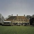 Overzicht van de achtergevel - Breda - 20384975 - RCE.jpg 1,200 × 1,200; 233 KB
-
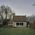
 Overzicht van de achtergevel van het bakhuis - Breda - 20384987 - RCE.jpg 1,200 × 1,200; 380 KB
-
 Overzicht van de achterzijde en zijgevel van de schuur - Breda - 20384982 - RCE.jpg 1,200 × 1,200; 296 KB
-
 Overzicht van de achterzijde en zijgevel van de schuur - Breda - 20384983 - RCE.jpg 1,200 × 1,200; 383 KB
-
 Overzicht van de linker zijgevel - Breda - 20384976 - RCE.jpg 1,200 × 1,200; 254 KB
-
 Overzicht van de linker zijgevel van het bakhuis - Breda - 20384988 - RCE.jpg 1,200 × 1,200; 345 KB
-
 Overzicht van de oprijlaan - Breda - 20385348 - RCE.jpg 1,200 × 1,200; 591 KB
-

-
 Overzicht van de tuin - Breda - 20385343 - RCE.jpg 1,200 × 1,200; 488 KB
-
 Overzicht van de tuin - Breda - 20385352 - RCE.jpg 1,200 × 1,200; 322 KB
-
 Overzicht van de tuin - Breda - 20385355 - RCE.jpg 1,200 × 1,200; 267 KB
-

-
 Overzicht van de tuin met het bakhuis op de achtergrond - Breda - 20385354 - RCE.jpg 1,200 × 1,200; 296 KB
-
 Overzicht van de tuin met zicht op de vijver - Breda - 20385357 - RCE.jpg 1,200 × 1,200; 428 KB
-
 Overzicht van de tuin met zicht op het landhuis - Breda - 20385346 - RCE.jpg 1,200 × 1,200; 290 KB
-
 Overzicht van de voor- en linker zijgevel van het bakhuis - Breda - 20384986 - RCE.jpg 1,200 × 1,200; 341 KB
-
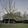
 Overzicht van de voorzijde van de schuur - Breda - 20384981 - RCE.jpg 1,200 × 1,200; 480 KB
-
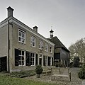
 Voorzijde - Princenhage - 20183288 - RCE.jpg 1,200 × 804; 231 KB
-
-
 Zicht op de voorgevel - Breda - 20384977 - RCE.jpg 1,200 × 1,200; 295 KB
-
 Zicht op een gedeelte van de oprijlaan - Breda - 20385349 - RCE.jpg 1,200 × 1,200; 513 KB
-
 Zicht op een gedeelte van de oprijlaan - Breda - 20385351 - RCE.jpg 1,200 × 1,200; 541 KB
-
 Zicht op gedeelte van de voorgevel - Breda - 20384974 - RCE.jpg 1,200 × 1,200; 346 KB
-
 Zicht op gedeelte van de voorgevel - Breda - 20384978 - RCE.jpg 1,200 × 1,200; 267 KB
-

-
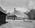
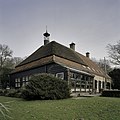
 Zoudtlandt.JPG 1,840 × 1,232; 1.17 MB


