Category:Zur Linde house
| Object location | | View all coordinates using: OpenStreetMap |
|---|
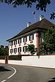
manor house in Kaiserstuhl in the canton of Aargau, Switzerland  | |||||
| Upload media | |||||
| Instance of |
| ||||
|---|---|---|---|---|---|
| Part of | |||||
| Location | Kaiserstuhl, Zurzach, Zurzach District, Aargau, Switzerland | ||||
| Street address |
| ||||
| Heritage designation | |||||
| Inception |
| ||||
 | |||||
Media in category "Zur Linde house"
The following 3 files are in this category, out of 3 total.
-
 Kaiserstuhl Linde.JPG 2,816 × 2,112; 1.08 MB
-
 Kaiserstuhl-Linde.jpg 600 × 900; 138 KB
-
 PATRIZIER HAUS - panoramio.jpg 640 × 480; 102 KB

