| KGS-Nr
|
Upload
|
Foto
|
|
Object
|
Other
|
Cov.
|
Cat.
|
Type
|
Address
|
Town
|
Coordinates
|
| 8716
|

|
|
|
Audiorama, Schweizerisches Museum für Ton und Bild
|
|

|
A
|
S
|
Avenue de Chillon 74
|
[[:Category:|]]
|
|
| 6242
|
|
yes
|

|
Bahnhof Montreux
|
|
|
A
|
G
|
Avenue des Alpes 74
|
[[:Category:|]]
|
|
| 6250
|
|
yes
|
|
Château des Crêtes
|
|
|
A
|
G
|
Avenue des Bosquets-de-Julie 13
|
{{{Town}}}
|
|
| 6240
|
|
yes
|
|
Château du Chatelard
|
|
|
A
|
G
|
Chemin Planchamp-Dessous 1
|
{{{Town}}}
|
|
| 6244
|
|
yes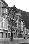
|
|
Ensemble mit ehemaligem Grand-Hôtel, Hôtel des Alpes
|
|
|
A
|
G
|
Avenue de Chillon 78, Territet
|
[[:Category:Avenue de Chillon 78, Territet|{{{Town}}}]]
|
|
| 6243
|
|
yes
|
|
Hôtel Montreux-Palace und Nebenbauten
|
|
|
A
|
G
|
Avenue des Alpes 100
|
[[:Category:|]]
|
|
| 6251
|
|
yes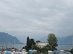
|
|
Insel und Villa Salagnon
|
|
|
A
|
G
|
Chemin de l’Île de Salagnon
|
[[:Category:|]]
|
|
| 6266
|
|
yes
|
|
Marché Couvert
|
|
|
A
|
G
|
Place du Marché
|
[[:Category:|]]
|
|
| 6246
|
|
yes
|
|
Palace Hôtel
|
|
|
A
|
G
|
Rue du Panorama 2, Caux
|
[[:Category:Rue du Panorama 2, Caux|{{{Town}}}]]
|
|
| 6241
|
|
yes
|
|
Villa Karma
|
|
|
A
|
G
|
Rue du Lac 171, Clarens
|
[[:Category:Rue du Lac 171, Clarens|{{{Town}}}]]
|
|
| 8956
|
|
|
|
Districtarchiv
|
|
|
B
|
S
|
Avenue Alexandre-Vinet 8, Clarens
|
[[:Category:|]]
|
|
| 6247
|
|
yes
|
|
Grand-Hôtel des Narcisses
|
|
|
B
|
G
|
Route de Villard 2, Chamby
|
[[:Category:|]]
|
|
| 6260
|
|
|
|
Hôtel du Righi vaudois mit Park
|
|
|
B
|
G
|
Route de Champ-Fleuri 3
|
[[:Category:|]]
|
|
| 6262
|
|
|
|
Hôtel Eden
|
|
|
B
|
G
|
Rue du Théâtre 11
|
[[:Category:|]]
|
|
| 6263
|
|
|
|
Hôtel Excelsior
|
|
|
B
|
G
|
Rue de Bon-Port 27
|
[[:Category:|]]
|
|
| 6264
|
|
|
|
Hôtel National mit Arkaden
|
|
|
B
|
G
|
Chemin du National 2
|
[[:Category:|]]
|
|
| 6265
|
|
|
|
Hôtel Suisse et Majestic
|
|
|
B
|
G
|
Avenue des Alpes 45
|
[[:Category:|]]
|
|
| 14674
|
|
|
|
Hôtel Villa Germaine
|
|
|
B
|
G
|
Rue de Collogne 1
|
[[:Category:|]]
|
|
| 6261
|
|
|
|
Hôtel Victoria
|
|
|
B
|
G
|
Route de Caux 16
|
[[:Category:|]]
|
|
| 6270
|
|
|
|
Institut Monte Rosa und Villa La Châtelaine
|
|
|
B
|
G
|
Avenue de Chillon 57
|
[[:Category:|]]
|
|
| 6254
|
|
yes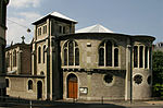
|
|
Katholische Kirche
|
|
|
B
|
G
|
Rue de l’Église catholique 14
|
[[:Category:|]]
|
|
| 6269
|
|
|
|
Kirche St. John’s
|
|
|
B
|
G
|
Avenue de Chillon 92, Territet
|
[[:Category:|]]
|
|
| 8958
|
|
|
|
Musée historique de Montreux
|
|
|
B
|
S
|
Rue de la Gare 40
|
[[:Category:|]]
|
|
| 6248
|
|
yes
|
|
Museumsbahn Blonay–Chamby (Anlagen)
|
|
|
B
|
X
|
Route de Chaulin
|
[[:Category:|]]
|
|
| 10683
|
|
yes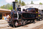
|
|
Museumsbahn Blonay–Chamby (Sammlung)
|
|
|
B
|
S
|
Route de Chaulin
|
[[:Category:|]]
|
|
| 6267
|
|
|
|
Pavillon des Sports du Palace
|
|
|
B
|
G
|
Grand-Rue 85
|
[[:Category:|]]
|
|
| 6268
|
|
yes
|
|
Reformierte Kirche Saint-Vincent und ehemaliges Beinhaus
|
|
|
B
|
G
|
Rue du Temple
|
[[:Category:|]]
|
|
| 6249
|
|
|
|
Schlachthof
|
|
|
B
|
G
|
Rue du Collège 42
|
[[:Category:|]]
|
|
| 14670
|
|
|
|
Standseilbahn Les Avants–Sonloup (Bergstation)
|
|
|
B
|
G
|
Sonloup
|
[[:Category:|]]
|
|
| 6256
|
|
|
|
Standseilbahn Les Avants–Sonloup (Talstation)
|
|
|
B
|
G
|
Les Avants
|
[[:Category:|]]
|
|
| 14671
|
|
|
|
Standseilbahn Territet–Glion (Bahnhof Glion)
|
|
|
B
|
G
|
Glion
|
[[:Category:Glion|{{{Town}}}]]
|
|
| 6257
|
|
|
|
Standseilbahn Territet–Glion (Bahnhof Territet)
|
|
|
B
|
G
|
Territet
|
[[:Category:|]]
|
|
| 14672
|
|
|
|
Standseilbahn Territet–Mont Fleuri (Bahnhof Mont Fleuri)
|
|
|
B
|
G
|
Route du Pré
|
[[:Category:|]]
|
|
| 6258
|
|
|
|
Standseilbahn Territet–Mont Fleuri (Bahnhof Territet)
|
|
|
B
|
G
|
Territet
|
[[:Category:|]]
|
|
| 6259
|
|
|
|
Valmont-Klinik
|
|
|
B
|
G
|
Route de Valmont 22, Glion
|
[[:Category:|]]
|
|
| 6272
|
|
|
|
Villa Florentine
|
|
|
B
|
G
|
Grand-Rue 83
|
[[:Category:|]]
|
|
| 6253
|
|
|
|
Villa Ormond
|
|
|
B
|
G
|
Rue du Lac 18, Clarens
|
[[:Category:|]]
|
|
| 6271
|
|
|
|
Villa Toscane
|
|
|
B
|
G
|
Rue du Lac 2
|
[[:Category:|]]
|
|
| 6252
|
|
|
|
Villenquartier Dubochet
|
|
|
B
|
G
|
Rue du Lac, Clarens
|
[[:Category:|]]
|
|
| 14675
|
|
|
|
Wohnsiedlung Bon-Port
|
|
|
B
|
G
|
Avenue de la Riviéra 10–22
|
[[:Category:|]]
|
|
| 6245
|
|
|
|
Zollhaus
|
|
|
B
|
G
|
Rue de la Douane
|
[[:Category:|]]
|
|

.jpg)


