| KGS-Nr
|
Upload
|
Foto
|
|
Object
|
Other
|
Cov.
|
Cat.
|
Type
|
Address
|
Town
|
Coordinates
|
| 8507
|

|
yes
|

|
Appenzeller Brauchtumsmuseum
|
|

|
A
|
S
|
Dorfplatz 8
|
[[:Category:|]]
|
|
| 552
|
|
yes
|
|
Wohnhaus mit Mühle
|
|
|
A
|
G
|
Müllstatt 1017/1019
|
[[:Category:|]]
|
|
| 11491
|
|
|
|
Bauernhaus
|
|
|
B
|
G
|
Ebni 696
|
[[:Category:|]]
|
|
| 11492
|
|
|
|
Bauernhaus
|
|
|
B
|
G
|
Hinterfür 980
|
[[:Category:|]]
|
|
| 11493
|
|
|
|
Bauernhaus
|
|
|
B
|
G
|
Letz 731
|
[[:Category:|]]
|
|
| 11494
|
|
|
|
Bauernhaus
|
|
|
B
|
G
|
Ruppen 477
|
[[:Category:|]]
|
|
| 11495
|
|
|
|
Bauernhaus
|
|
|
B
|
G
|
Schafhölzli 520
|
[[:Category:|]]
|
|
| 549
|
|
|
|
Bauernhaus
|
|
|
B
|
G
|
Rain 632
|
[[:Category:|]]
|
|
| 550
|
|
|
|
Bauernhaus
|
|
|
B
|
G
|
Eggrüti 674
|
[[:Category:|]]
|
|
| 11499
|
|
|
|
Bauernhaus
|
|
|
B
|
G
|
Rossweid 978
|
[[:Category:|]]
|
|
| 14910
|
|
|
|
Gasthaus Rossfall
|
|
|
B
|
G
|
Rossfall 424
|
[[:Category:|]]
|
|
| 11496
|
|
|
|
Heidenhaus
|
|
|
B
|
G
|
Schwaderau 469
|
[[:Category:|]]
|
|
| 11400
|
|
|
|
Tätschdachhaus
|
|
|
B
|
G
|
Dürrenbach 366
|
[[:Category:|]]
|
|
| 11399
|
|
|
|
Weberhöckli
|
|
|
B
|
G
|
Unterdorfstrasse 60
|
[[:Category:|]]
|
|
| 11498
|
|
|
|
Wohnhaus
|
|
|
B
|
G
|
Untere Egg 521
|
[[:Category:|]]
|
|
|
|
|
yes
|
|
Alte Apotheke
|
|
|
|
G
|
Dorfplatz 8
|
[[:Category:|]]
|
|
|
|
|
|
|
Haus
|
|
|
|
G
|
Dorfplatz 2
|
[[:Category:|]]
|
|
|
|
|
yes
|
|
Haus
|
|
|
|
G
|
Dorfplatz 4
|
[[:Category:|]]
|
|
|
|
|
|
|
Haus
|
|
|
|
G
|
Dorfplatz 5
|
[[:Category:|]]
|
|
|
|
|
|
|
Haus
|
|
|
|
G
|
Dorfplatz 6
|
[[:Category:|]]
|
|
|
|
|
|
|
Haus
|
|
|
|
G
|
Dorfplatz 7
|
[[:Category:|]]
|
|
|
|
|
|
|
Haus
|
|
|
|
G
|
Dorfplatz 10
|
[[:Category:|]]
|
|
|
|
|
|
|
Haus
|
|
|
|
G
|
Dorfplatz 12
|
[[:Category:|]]
|
|
|
|
|
|
|
Haus
|
|
|
|
G
|
Dorfplatz 14
|
[[:Category:|]]
|
|
|
|
|
|
|
Haus
|
|
|
|
G
|
Dorfplatz 16
|
[[:Category:|]]
|
|
|
|
|
|
|
Haus
|
|
|
|
G
|
Müli 1010
|
[[:Category:|]]
|
|
|
|
|
|
|
Haus
|
|
|
|
G
|
Schwägalpstrasse 12
|
[[:Category:|]]
|
|
|
|
|
|
|
Haus
|
|
|
|
G
|
Schwägalpstrasse 60
|
[[:Category:|]]
|
|
|
|
|
|
|
Haus
|
|
|
|
G
|
Unterdorfstrasse 2
|
[[:Category:|]]
|
|
|
|
|
|
|
Nebengebäude
|
|
|
|
G
|
Mettlenweg 2
|
[[:Category:|]]
|
|
|
|
|
yes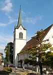
|
|
Reformierte Kirche
|
|
|
|
G
|
Dorfplatz 5
|
[[:Category:|]]
|
|


