| Location
|
Upload
|
Photo
|
Object
|
Cat.
|
Coordinates
|
KGS-Nr
|
| Adlikon bei Andelfingen
|

|
yes
|


|
Thurbrücke Ossingen
|
A
|
47°36′06″N 8°43′25″E / 47.60167°N 8.723681°E / 47.60167; 8.723681
|
10506
|
| Adliswil
|
|
yes
|
|
Ehemalige mechanisierte Seidenweberei mit MSA-Steg (1907) und Wohnsiedlung Sihlau
|
B
|
47°18′23″N 8°31′31″E / 47.306445°N 8.525326°E / 47.306445; 8.525326
|
12501
|
| Adliswil
|
|
yes
|
|
Katholische Kirche (1905, Hardegger)
|
B
|
47°18′47″N 8°31′20″E / 47.313029°N 8.522287°E / 47.313029; 8.522287
|
7382
|
| Aesch
|
|

|
|
Grabhügelgruppe
|
B
|
47°20′11″N 8°25′38″E / 47.336265°N 8.427221°E / 47.336265; 8.427221
|
14816
|
| Aeugst am Albis
|
|
yes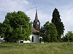
|
|
Reformierte Kirche (1667) mit Pfarrhaus
|
B
|
47°16′01″N 8°29′17″E / 47.267027°N 8.488145°E / 47.267027; 8.488145
|
7384
|
| Aeugst am Albis
|
|
yes
|
|
Seeufersiedlung
|
B
|
47°15′57″N 8°30′09″E / 47.265946°N 8.502367°E / 47.265946; 8.502367
|
12502
|
| Aeugst am Albis
|
|
yes
|
|
Bergwerk Riedhof
|
B
|
47°17′14″N 8°28′50″E / 47.287284°N 8.480582°E / 47.287284; 8.480582
|
12503
|
| Affoltern am Albis
|
|
yes
|
|
Sammlungszentrum des Schweizerischen Nationalmuseums
|
A
|
47°16′09″N 8°26′45″E / 47.269285°N 8.445847°E / 47.269285; 8.445847
|
11777
|
| Affoltern am Albis
|
|
yes
|
|
Allmend, Mühliberg, Weidmauer
|
B
|
47°17′19″N 8°28′25″E / 47.2886924°N 8.47372402°E / 47.2886924; 8.47372402
|
7385
|
| Affoltern am Albis
|
|
yes
|
|
Butzenhaus
|
B
|
47°16′36″N 8°27′37″E / 47.276679°N 8.460142°E / 47.276679; 8.460142
|
12505
|
| Affoltern am Albis
|
|
yes
|
|
Druckereigebäude Weiss
|
B
|
47°16′36″N 8°27′03″E / 47.276698°N 8.450784°E / 47.276698; 8.450784
|
12504
|
| Albisrieden
|
|
yes
|
|
Max-Frisch-Bad
|
A
|
47°22′46″N 8°29′59″E / 47.379452777°N 8.499702777°E / 47.379452777; 8.499702777
|
9004
|
| Albisrieden
|
|
yes
|
|
Schulhaus Letzi (E. Gisel)
|
B
|
47°22′15″N 8°29′50″E / 47.3707°N 8.49712°E / 47.3707; 8.49712
|
9018
|
| Andelfingen
|
|
yes
|
|
Haldenmühle mit Nebenbauten
|
A
|
47°35′47″N 8°40′50″E / 47.596527°N 8.680539°E / 47.596527; 8.680539
|
10063
|
| Andelfingen
|
|
|
|
Bahnhof (1857)
|
B
|
47°35′38″N 8°40′41″E / 47.593864°N 8.678056°E / 47.593864; 8.678056
|
7387
|
| Andelfingen
|
|
yes
|
|
Gedeckte Brücke über die Thur (1815, Stadler) mit ehem. Zollhaus
|
B
|
47°35′49″N 8°40′53″E / 47.597066°N 8.681456°E / 47.597066; 8.681456
|
7389
|
| Andelfingen
|
|
|
|
Hochlaufen, Gräberfeld und Wallanlage (latène-zeitlich)
|
B
|
47°35′28″N 8°39′53″E / 47.591218°N 8.664699°E / 47.591218; 8.664699
|
7390
|
| Andelfingen
|
|
|
|
Lindenmühle
|
B
|
47°35′43″N 8°40′44″E / 47.595141°N 8.678977°E / 47.595141; 8.678977
|
12506
|
| Andelfingen
|
|
|
|
Prähistorische / Frühmittelalterliche Siedlung
|
B
|
47°35′43″N 8°40′28″E / 47.595343°N 8.674453°E / 47.595343; 8.674453
|
12507
|
| Andelfingen
|
|
yes
|
|
Reformierte Kirche (1667, 1861) und Pfarrhaus
|
B
|
47°35′41″N 8°40′42″E / 47.594815°N 8.678331°E / 47.594815; 8.678331
|
7391
|
| Andelfingen
|
|
yes
|
|
Schloss mit Nebenbauten und Parkanlage
|
B
|
47°35′46″N 8°40′48″E / 47.59601°N 8.680088°E / 47.59601; 8.680088
|
12508
|
| Andelfingen
|
|
yes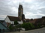
|
|
Andelfingen
|
ISOS
|
47°35′41″N 8°40′44″E / 47.594722222°N 8.678888888°E / 47.594722222; 8.678888888
|
|
| Bachs
|
|
|
|
Hohflue, Balmburg
|
B
|
47°32′31″N 8°24′49″E / 47.542065°N 8.413585°E / 47.542065; 8.413585
|
12509
|
| Bachs
|
|
yes
|
|
Bachs
|
ISOS
|
47°31′29″N 8°26′21″E / 47.524722222°N 8.439166666°E / 47.524722222; 8.439166666
|
|
| Bäretswil
|
|
yes
|
|
Ehemalige Baumwollspinnerei Neuthal
|
A
|
47°21′34″N 8°51′55″E / 47.359412°N 8.86539°E / 47.359412; 8.86539
|
7393
|
| Bäretswil
|
|
yesGreifenberg, Burgstelle
|
|
Greifenberg, Burgstelle
|
A
|
47°20′46″N 8°51′52″E / 47.346146°N 8.864479°E / 47.346146; 8.864479
|
7394
|
| Bäretswil
|
|
yes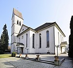
|
|
Reformierte Kirche (1827, Turm 1504)
|
B
|
47°20′15″N 8°51′21″E / 47.33739°N 8.855908°E / 47.33739; 8.855908
|
7395
|
| Bäretswil
|
|
yes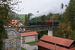
|
|
Neuthal
|
ISOS
|
47°21′35″N 8°51′51″E / 47.359722222°N 8.864166666°E / 47.359722222; 8.864166666
|
|
| Bassersdorf
|
|
yes
|
|
Baltenswil, Landheim (1844, ehem. Gasthof Schwanen)
|
B
|
47°25′40″N 8°38′17″E / 47.427771°N 8.637992°E / 47.427771; 8.637992
|
7396
|
| Bauma
|
|
yes
|
|
Flarz mit Haus Freddi
|
A
|
47°22′48″N 8°51′19″E / 47.380073°N 8.855388°E / 47.380073; 8.855388
|
9504
|
| Bauma
|
|
yes
|
|
Dampfbahn-Verein Zürcher Oberland
|
B
|
47°22′07″N 8°52′50″E / 47.368561°N 8.8805°E / 47.368561; 8.8805
|
7400
|
| Bauma
|
|
yes
|
|
Ruine Alt-Landenberg
|
B
|
47°22′22″N 8°52′20″E / 47.37277°N 8.87209°E / 47.37277; 8.87209
|
14817
|
| Bauma
|
|
yes
|
|
Alt-Landenberg, Doppelbauernhaus (1764)
|
B
|
47°22′22″N 8°52′09″E / 47.372751°N 8.869177°E / 47.372751; 8.869177
|
7397
|
| Bauma
|
|
yes
|
|
Bauernhaus
|
B
|
47°23′00″N 8°54′03″E / 47.383257°N 8.900942°E / 47.383257; 8.900942
|
7670
|
| Bauma
|
|
yes
|
|
Fabrikanlage mit Villen
|
B
|
47°23′08″N 8°51′33″E / 47.385615°N 8.859058°E / 47.385615; 8.859058
|
7399
|
| Bauma
|
|
yes
|
|
Friedhof, Familiengrab Guyer (1900)
|
B
|
47°21′57″N 8°52′40″E / 47.365941°N 8.877892°E / 47.365941; 8.877892
|
7398
|
| Bauma
|
|
yes
|
|
Reformierte Kirche (1771, Turm 1651)
|
B
|
47°22′02″N 8°52′37″E / 47.367211°N 8.877039°E / 47.367211; 8.877039
|
7401
|
| Bauma
|
|
yes
|
|
Vordertüfenbach, Doppelbauernhaus Kägi (1785)
|
B
|
47°22′01″N 8°53′44″E / 47.367014°N 8.895677°E / 47.367014; 8.895677
|
7403
|
| Bauma
|
|
|
|
Wellenau
|
ISOS
|
47°21′54″N 8°54′27″E / 47.36499°N 8.90747°E / 47.36499; 8.90747
|
|
| Benken
|
|
|
|
Ehemalige Mühle mit Nebenbauten
|
B
|
47°39′16″N 8°39′24″E / 47.654552°N 8.656745°E / 47.654552; 8.656745
|
12510
|
| Benken
|
|
|
|
Gasthaus zur Sonne
|
B
|
47°39′13″N 8°39′09″E / 47.653732°N 8.652533°E / 47.653732; 8.652533
|
12511
|
| Benken
|
|
|
|
Hämmenriet, Viereckschanze
|
B
|
47°38′47″N 8°38′29″E / 47.646418°N 8.641504°E / 47.646418; 8.641504
|
12512
|
| Benken
|
|
yes
|
|
Reformierte Kirche
|
B
|
47°39′10″N 8°39′14″E / 47.652727°N 8.654027°E / 47.652727; 8.654027
|
12513
|
| Benken
|
|
yes
|
|
Benken
|
ISOS
|
47°39′15″N 8°39′14″E / 47.654166666°N 8.653888888°E / 47.654166666; 8.653888888
|
|
| Berg am Irchel
|
|
yes
|
|
Ebersberg, Teil der spätrömischen Rheinbefestigung
|
A
|
47°34′19″N 8°34′45″E / 47.571808°N 8.579054°E / 47.571808; 8.579054
|
11655
|
| Berg am Irchel
|
|
|
|
Höhensiedlung
|
B
|
47°34′19″N 8°34′44″E / 47.571993°N 8.578758°E / 47.571993; 8.578758
|
14818
|
| Berg am Irchel
|
|
|
|
Irchel, Wallanlage, Schartenflue
|
B
|
47°33′06″N 8°35′45″E / 47.55154°N 8.595758°E / 47.55154; 8.595758
|
7407
|
| Berg am Irchel
|
|
yes
|
|
Reformierte Kirche
|
B
|
47°34′14″N 8°35′53″E / 47.570443°N 8.597938°E / 47.570443; 8.597938
|
12514
|
| Berg am Irchel
|
|
|
|
Schloss Berg (1642) mit Orangerie (um 1800)
|
B
|
47°34′10″N 8°35′58″E / 47.569314°N 8.599335°E / 47.569314; 8.599335
|
7408
|
| Berg am Irchel
|
|
yes
|
|
Schloss Eigental (1588, 1667)
|
B
|
47°34′10″N 8°36′21″E / 47.569384°N 8.605769°E / 47.569384; 8.605769
|
7409
|
| Berg am Irchel
|
|
|
|
Schlossbuck Burg / Burgstelle / Motte
|
B
|
47°33′56″N 8°34′24″E / 47.565437°N 8.573222°E / 47.565437; 8.573222
|
14819
|
| Berg am Irchel
|
|
yes
|
|
Berg am Irchel
|
ISOS
|
47°33′59″N 8°35′59″E / 47.566388888°N 8.599722222°E / 47.566388888; 8.599722222
|
|
| Birmensdorf
|
|
yes
|
|
Grabhügel MBZ
|
B
|
47°21′36″N 8°26′56″E / 47.359932°N 8.44892°E / 47.359932; 8.44892
|
12515
|
| Birmensdorf
|
|
yes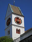
|
|
Reformierte Kirche (1659, Turm 12. Jh.), mit Pfarrhaus (1650)
|
B
|
47°21′06″N 8°26′28″E / 47.351622°N 8.441154°E / 47.351622; 8.441154
|
7410
|
| Boppelsen
|
|
yes
|
|
Ruine Alt-Lägern
|
B
|
47°28′55″N 8°23′38″E / 47.481866°N 8.393998°E / 47.481866; 8.393998
|
12516
|
| Boppelsen
|
|
|
|
Silexbergbau
|
B
|
47°28′45″N 8°23′46″E / 47.479249°N 8.396114°E / 47.479249; 8.396114
|
12517
|
| Brütten
|
|
yes
|
|
Reformierte Kirche
|
B
|
47°28′27″N 8°40′27″E / 47.474066°N 8.674192°E / 47.474066; 8.674192
|
12518
|
| Bubikon
|
|
yes
|
|
Ritterhaus Bubikon
|
A
|
47°16′00″N 8°49′41″E / 47.266666666°N 8.828055555°E / 47.266666666; 8.828055555
|
7411
|
| Bubikon
|
|
|
|
Barenberg, Wohnhaus (1707) mit Waschhaus
|
B
|
47°15′09″N 8°49′11″E / 47.252476°N 8.8197°E / 47.252476; 8.8197
|
7412
|
| Bubikon
|
|
|
|
Feldscheune Pösch
|
B
|
47°15′59″N 8°48′34″E / 47.266275°N 8.809311°E / 47.266275; 8.809311
|
12519
|
| Buchs
|
|
|
|
Ehem. Quarzsandbergwerk
|
B
|
47°27′31″N 8°27′13″E / 47.458491°N 8.45359°E / 47.458491; 8.45359
|
7413
|
| Buchs
|
|
yes
|
|
Mühleberg, römischer Gutshof mit Kryptoportikus
|
B
|
47°27′44″N 8°26′07″E / 47.462185°N 8.435318°E / 47.462185; 8.435318
|
7414
|
| Bülach
|
|
yes
|
|
Dreifaltigkeitskirche
|
B
|
47°31′17″N 8°32′07″E / 47.5213°N 8.53521°E / 47.5213; 8.53521
|
7418
|
| Bülach
|
|
|
|
Alte Burg bzw. «Mangoldsburg«, Wallanlage
|
B
|
47°32′39″N 8°31′16″E / 47.544165°N 8.521207°E / 47.544165; 8.521207
|
7415
|
| Bülach
|
|
yes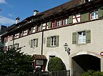
|
|
Altstadt mit Mauerring (18 Teilstücke) und Vorstadt
|
B
|
47°31′03″N 8°32′28″E / 47.517445°N 8.541127°E / 47.517445; 8.541127
|
7416
|
| Bülach
|
|
yes
|
|
Rathaus (1673), (Gemeindearchiv)
|
B
|
47°31′02″N 8°32′28″E / 47.517327°N 8.541028°E / 47.517327; 8.541028
|
7419
|
| Bülach
|
|
yes
|
|
Rinsberg, Wallanlage «Schanzbuck« und römische Warte «Schatz«
|
B
|
47°33′20″N 8°32′29″E / 47.555668°N 8.541372°E / 47.555668; 8.541372
|
7420
|
| Bülach
|
|
yes
|
|
Villa Neuhof mit Gartenhaus, (1839, ehem. Doktorhaus)
|
B
|
47°31′08″N 8°32′25″E / 47.518873°N 8.540197°E / 47.518873; 8.540197
|
7421
|
| Bülach
|
|
yes
|
|
Bülach
|
ISOS
|
47°31′08″N 8°32′32″E / 47.518888888°N 8.542222222°E / 47.518888888; 8.542222222
|
|
| Dachsen
|
|
|
|
Bahnhof (1857) und ehem. Hotel Witzig (jetzt Lehrlingsheim Georg Fischer)
|
B
|
47°40′03″N 8°36′49″E / 47.667479°N 8.613733°E / 47.667479; 8.613733
|
7422
|
| Dachsen
|
|
yes
|
|
Bahnhof mit Güterschuppen
|
B
|
47°40′02″N 8°36′50″E / 47.667145°N 8.613885°E / 47.667145; 8.613885
|
12520
|
| Dachsen
|
|
|
|
Ehem. Untervogtshaus
|
B
|
47°39′51″N 8°37′07″E / 47.664201°N 8.618613°E / 47.664201; 8.618613
|
7423
|
| Dachsen
|
|
yes
|
|
Kapelle
|
B
|
47°39′53″N 8°37′08″E / 47.664737°N 8.618958°E / 47.664737; 8.618958
|
7424
|
| Dägerlen
|
|
yes
|
|
Reformierte Kirche
|
B
|
47°33′39″N 8°43′19″E / 47.560843°N 8.722029°E / 47.560843; 8.722029
|
12521
|
| Dägerlen
|
|
yes
|
|
Dägerlen
|
ISOS
|
47°33′43″N 8°43′23″E / 47.561944444°N 8.723055555°E / 47.561944444; 8.723055555
|
|
| Dällikon
|
|
|
|
Mühlerain / Chneblezen, römischer Gutshof
|
B
|
47°26′10″N 8°26′15″E / 47.436084°N 8.437494°E / 47.436084; 8.437494
|
12522
|
| Dällikon
|
|
yes
|
|
Reformierte Kirche
|
B
|
47°26′24″N 8°26′21″E / 47.439926°N 8.439104°E / 47.439926; 8.439104
|
12523
|
| Dättlikon
|
|
|
|
Reformierte Kirche (13. Jh., 1522) mit Pfarrhaus
|
B
|
47°31′29″N 8°37′27″E / 47.524861°N 8.62422°E / 47.524861; 8.62422
|
7425
|
| Dielsdorf
|
|
|
|
Speicher (17. Jh.)
|
B
|
47°28′57″N 8°27′19″E / 47.482528°N 8.455283°E / 47.482528; 8.455283
|
7426
|
| Dietikon
|
|
yes
|
|
Ruine Schönenwerd
|
B
|
47°23′54″N 8°25′42″E / 47.398434°N 8.428442°E / 47.398434; 8.428442
|
7428
|
| Dietikon
|
|
yes
|
|
Katholische Kirche St. Agatha (1927, Gaudy) mit Pfarrhaus
|
B
|
47°24′18″N 8°24′14″E / 47.404991°N 8.403987°E / 47.404991; 8.403987
|
7427
|
| Dietikon
|
|
yes
|
|
Wärterhaus mit Wartehalle des ersten Bahnhofs (1847)
|
B
|
47°24′27″N 8°24′17″E / 47.4075763°N 8.40465681°E / 47.4075763; 8.40465681
|
7429
|
| Dinhard
|
|
yes
|
|
Reformierte Kirche (1515), mit Pfarrhaus
|
B
|
47°33′14″N 8°46′36″E / 47.553919°N 8.776698°E / 47.553919; 8.776698
|
7430
|
| Dinhard
|
|
|
|
Kirch Dinhard
|
ISOS
|
47°33′10″N 8°47′11″E / 47.5529°N 8.7864°E / 47.5529; 8.7864
|
|
| Dorf
|
|
yes
|
|
Schloss Goldenberg mit Oekonomiegebäuden
|
B
|
47°34′30″N 8°39′19″E / 47.575038°N 8.655154°E / 47.575038; 8.655154
|
7431
|
| Dübendorf
|
|
yes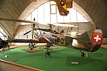
|
|
Flieger Flab Museum
|
A
|
47°23′53″N 8°37′52″E / 47.398044°N 8.630978°E / 47.398044; 8.630978
|
8554
|
| Dübendorf
|
|
yes
|
|
Militärflugplatz Dübendorf
|
A
|
47°23′55″N 8°38′54″E / 47.398644444°N 8.648230555°E / 47.398644444; 8.648230555
|
9066
|
| Dübendorf
|
|
|
|
Militärhistorische Sammlung (vgl. Burgdorf/BE und Thun/BE)
|
A
|
47°24′00″N 8°37′31″E / 47.400082°N 8.625247°E / 47.400082; 8.625247
|
11775
|
| Dübendorf
|
|
yes
|
|
Werkstattgebäude 1
|
A
|
47°24′02″N 8°37′45″E / 47.400615°N 8.629207°E / 47.400615; 8.629207
|
7433
|
| Dübendorf
|
|
yes
|
|
Lazariterkirche Gfenn
|
B
|
47°23′32″N 8°38′53″E / 47.392288°N 8.648016°E / 47.392288; 8.648016
|
7432
|
| Dübendorf
|
|
yes
|
|
Ruine Dübelstein
|
B
|
47°22′48″N 8°36′56″E / 47.379897°N 8.615554°E / 47.379897; 8.615554
|
14821
|
| Dübendorf
|
|
yes
|
|
Eidgenössische Materialprüfungs- und Forschungsanstalt (EMPA), Archiv
|
B
|
47°24′08″N 8°36′41″E / 47.402185°N 8.611343°E / 47.402185; 8.611343
|
8897
|
| Dübendorf
|
|
|
|
AGFA-Gebäude mit Sammlung Archäologie und Denkmalpflege
|
B
|
47°23′41″N 8°36′04″E / 47.394643°N 8.601056°E / 47.394643; 8.601056
|
12524
|
| Dübendorf
|
|
yes
|
|
Ehemaliger Militärflugplatz
|
B
|
47°24′03″N 8°37′51″E / 47.400968°N 8.630924°E / 47.400968; 8.630924
|
10375
|
| Dübendorf
|
|
yes
|
|
Unterrichtsgebäude u. Startpavillon
|
B
|
47°24′07″N 8°37′41″E / 47.401898°N 8.627964°E / 47.401898; 8.627964
|
9067
|
| Dürnten
|
|
yes
|
|
Reformierte Kirche
|
A
|
47°16′41″N 8°50′35″E / 47.278111°N 8.843073°E / 47.278111; 8.843073
|
7434
|
| Dürnten
|
|
|
|
Rüti mit Untertann
|
ISOS
|
47°15′36″N 8°51′15″E / 47.2601°N 8.8541°E / 47.2601; 8.8541
|
|
| Egg
|
|
yes
|
|
St.-Antonius-Kirche
|
B
|
47°17′58″N 8°41′12″E / 47.299385°N 8.68672°E / 47.299385; 8.68672
|
12531
|
| Egg
|
|
yes
|
|
Pfannenstilturm, ehemaliger Bachtelturm (1893)
|
B
|
47°17′27″N 8°40′24″E / 47.290767°N 8.673402°E / 47.290767; 8.673402
|
12532
|
| Egg
|
|
yes
|
|
Rällikerholz, Wallanlage
|
B
|
47°19′00″N 8°41′26″E / 47.316678°N 8.690537°E / 47.316678; 8.690537
|
7435
|
| Egg
|
|
yes
|
|
Rällikon, Doppelwohnhaus (1535, 18. und 19. Jh., ehem. Taverne)
|
B
|
47°19′04″N 8°41′54″E / 47.31768°N 8.698471°E / 47.31768; 8.698471
|
7436
|
| Egg
|
|
yes
|
|
Reformierte Kirche
|
B
|
47°18′02″N 8°41′29″E / 47.300549°N 8.691362°E / 47.300549; 8.691362
|
12533
|
| Egg
|
|
yes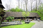
|
|
Sog. Thommensägi
|
B
|
47°18′22″N 8°41′04″E / 47.306193°N 8.684419°E / 47.306193; 8.684419
|
12534
|
| Eglisau
|
|
yes
|
|
Reformierte Kirche Eglisau
|
A
|
47°34′30″N 8°31′33″E / 47.575127°N 8.52591°E / 47.575127; 8.52591
|
7440
|
| Eglisau
|
|
yes
|
|
Gasthof Hirschen
|
A
|
47°34′31″N 8°31′31″E / 47.575277777°N 8.525277777°E / 47.575277777; 8.525277777
|
7439
|
| Eglisau
|
|
yes[[File:|150x150px|Rhinsberg, spätbronzezeitliche Höhensiedlung / neuzeitliche Hochwacht]]
|
|
Rhinsberg, spätbronzezeitliche Höhensiedlung / neuzeitliche Hochwacht
|
A
|
47°33′34″N 8°32′10″E / 47.559496°N 8.53607°E / 47.559496; 8.53607
|
9707
|
| Eglisau
|
|
yes
|
|
Weierbachhaus
|
B
|
47°34′32″N 8°31′42″E / 47.575679°N 8.528204°E / 47.575679; 8.528204
|
12535
|
| Eglisau
|
|
yes
|
|
Schloss Eglisau
|
B
|
47°34′27″N 8°31′29″E / 47.574111111°N 8.524833333°E / 47.574111111; 8.524833333
|
12733
|
| Eglisau
|
|
yes
|
|
Gasthaus zur Krone
|
B
|
47°34′32″N 8°31′27″E / 47.57561°N 8.524094°E / 47.57561; 8.524094
|
12536
|
| Eglisau
|
|
yes
|
|
Reformiertes Pfarrhaus
|
B
|
47°34′31″N 8°31′32″E / 47.575236°N 8.525562°E / 47.575236; 8.525562
|
12541
|
| Eglisau
|
|
yes
|
|
Eisenbahnbrücke Eglisau
|
B
|
47°34′39″N 8°30′37″E / 47.577613888°N 8.510377777°E / 47.577613888; 8.510377777
|
7438
|
| Eglisau
|
|
yes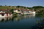
|
|
Eglisau
|
ISOS
|
47°34′24″N 8°31′34″E / 47.57335°N 8.52607°E / 47.57335; 8.52607
|
|
| Elgg
|
|
yes
|
|
Schloss Elgg
|
A
|
47°29′00″N 8°51′57″E / 47.483416666°N 8.865833333°E / 47.483416666; 8.865833333
|
7444
|
| Elgg
|
|
yes
|
|
Reformierte Kirche mit Pfarrhaus
|
A
|
47°29′24″N 8°52′03″E / 47.490121°N 8.867436°E / 47.490121; 8.867436
|
7443
|
| Elgg
|
|
yes
|
|
Haus zur Meise (1645)
|
B
|
47°29′26″N 8°52′03″E / 47.490595°N 8.867621°E / 47.490595; 8.867621
|
7442
|
| Elgg
|
|
yes
|
|
Kohlebergwerk
|
B
|
47°30′16″N 8°52′23″E / 47.504567505°N 8.873189671°E / 47.504567505; 8.873189671
|
12542
|
| Elgg
|
|
yes
|
|
Wohnhaus Sulzerhof mit Parkanlage
|
B
|
47°29′42″N 8°53′37″E / 47.495128°N 8.893641°E / 47.495128; 8.893641
|
12543
|
| Elsau
|
|
|
|
Burgstelle
|
B
|
47°29′58″N 8°47′39″E / 47.499467°N 8.79414°E / 47.499467; 8.79414
|
12544
|
| Elsau
|
|
|
|
Räterschen, ehem. Baumwollspinnerei (19. Jh.)
|
B
|
47°29′51″N 8°47′55″E / 47.497553°N 8.798508°E / 47.497553; 8.798508
|
7446
|
| Embrach
|
|
yes
|
|
Chorherrenstift St. Peter Embrach
|
B
|
47°30′07″N 8°35′46″E / 47.50194°N 8.596047°E / 47.50194; 8.596047
|
9810
|
| Embrach
|
|
yes
|
|
Reformierte Kirche
|
B
|
47°30′04″N 8°35′43″E / 47.5012°N 8.595314°E / 47.5012; 8.595314
|
12548
|
| Embrach
|
|
|
|
Altes Schul- und Gemeindehaus
|
B
|
47°30′06″N 8°35′42″E / 47.50167°N 8.595112°E / 47.50167; 8.595112
|
12545
|
| Embrach
|
|
yesBahnhof Embrach-Rorbas (1907) mit Güterschuppen (1876)
|
|
Bahnhof Embrach-Rorbas (1907) mit Güterschuppen (1876)
|
B
|
47°31′14″N 8°35′13″E / 47.52055°N 8.587038°E / 47.52055; 8.587038
|
7447
|
| Embrach
|
|
|
|
Burg, Erdwerk und Burgruine Heidegg
|
B
|
47°30′37″N 8°34′42″E / 47.510336°N 8.5784°E / 47.510336; 8.5784
|
7448
|
| Embrach
|
|
|
|
Ehemalige Transformatorenstation Bächli-Unterdorf
|
B
|
47°30′35″N 8°35′36″E / 47.509829°N 8.593205°E / 47.509829; 8.593205
|
12547
|
| Embrach
|
|
|
|
Ehemaliges Amtshaus
|
B
|
47°30′06″N 8°35′48″E / 47.501539°N 8.596543°E / 47.501539; 8.596543
|
12546
|
| Embrach
|
|
|
|
Villa Ganz mit Nebenbauten
|
B
|
47°30′10″N 8°35′42″E / 47.50284°N 8.595084°E / 47.50284; 8.595084
|
12549
|
| Enge
|
|
yes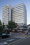
|
|
Hochhaus zur Palme
|
B
|
47°22′00″N 8°32′02″E / 47.3666°N 8.5338°E / 47.3666; 8.5338
|
10382
|
| Erlenbach
|
|
|
|
Landhaus Erlengut
|
B
|
47°18′08″N 8°35′37″E / 47.302099°N 8.593738°E / 47.302099; 8.593738
|
12553
|
| Erlenbach
|
|
|
|
Landhaus Turmgut mit Rebturm
|
B
|
47°18′05″N 8°35′47″E / 47.30129°N 8.596366°E / 47.30129; 8.596366
|
12554
|
| Erlenbach
|
|
|
|
Landsitz Mariahalde (1770)
|
B
|
47°17′42″N 8°35′56″E / 47.295056°N 8.59902°E / 47.295056; 8.59902
|
7450
|
| Erlenbach
|
|
|
|
Seeufersiedlung
|
B
|
47°18′21″N 8°35′17″E / 47.305783°N 8.588064°E / 47.305783; 8.588064
|
12552
|
| Erlenbach
|
|
yes
|

|
Erlenbach-Winkel
|
B+UNESCO
|
47°17′50″N 8°35′46″E / 47.297201°N 8.596209°E / 47.297201; 8.596209
|
12551
|
| Erlenbach
|
|
yes
|
|
Landgut mit Seeuferhang
|
ISOS
|
47°17′38″N 8°35′58″E / 47.29396°N 8.59952°E / 47.29396; 8.59952
|
|


_ShiftN.jpg)


.jpg)


