Daventry
market town and civil parish in Northamptonshire, England
English: Daventry is a district, town and a parish in Northamptonshire, United Kingdom.
Español: Daventry es un barrio , ciudad y una parroquia en Northamptonshire, Reino Unido.
Português: Daventry é um distrito , cidade e uma paróquia em Northamptonshire , Reino Unido.
District and Town location
edit
Daventry on Wikipedia
edit|
Български: Daventry
Cymraeg: Daventry
Deutsch: Daventry
English: Daventry
|
فارسی: Daventry
Français : Daventry
Gaeilge: Daventry
Italiano: Daventry
|
Nederlands: Daventry
Norsk bokmål: Daventry
Norsk nynorsk: Daventry
Polski: Daventry
|
Română: Daventry
Simple English: Daventry
Svenska: Daventry
Volapük: Daventry
|
Buildings
editReligious buildings
editHoly Cross Church (Exterior)
edit52°15′29.9″N 1°09′32.5″W / 52.258306°N 1.159028°W
-
 Front Elevation
 -
 Rear Elevation
 -
 South Elevation
 -

-


Holy Cross Church (Interior)
edit


English: See:Category:Holy Cross Church, Daventry
Daventry Methodist Church
edit52°15′37.1″N 1°09′35.6″W / 52.260306°N 1.159889°W


Our Lady of Charity and Saint Augustine Catholic Church
edit52°15′29.9″N 1°09′32.5″W / 52.258306°N 1.159028°W
-

-

-
 Presbyterie House next to Our Lady of Charity and Saint Augustine Roman Catholic Church


Daventry United Reformed Church
edit52°15′24.1″N 1°09′44.9″W / 52.256694°N 1.162472°W


Other Chapels and Churches
edit-
 Chapel at Danetre Hospital
 -
 Vineyard community church
 -
 Kingdom Hall of Jehovah's Witnesses


Municipal and administrate buildings
editDaventry and District Council Headquarters
edit52°15′36.2″N 1°09′30.9″W / 52.260056°N 1.158583°W


Daventry Magistrates Court
edit52°15′22.1″N 1°09′43.1″W / 52.256139°N 1.161972°W

Daventry Police Station
edit52°15′22.4″N 1°09′42.4″W / 52.256222°N 1.161778°W
-

-
 Rear Elevation


Historical Buildings
editMoot Hall
edit52°15′31.5″N 1°09′38.2″W / 52.25875°N 1.160611°W


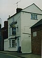
Wheatsheaf Coaching Inn
edit52°15′22.4″N 1°09′44.9″W / 52.256222°N 1.162472°W


Other Historical Buildings
edit-
 Old Grammer School
 -
 Former Workhouse
 -
 Beehive cottage


Transport
editBuses and Trains
edit-
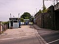
 The Bus station
 -
 The Bus station
 -
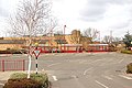
 Long Buckby railway station
 -


Streets and avenues
editHigh Street
edit-
 Western end of High Street
 -
 Eastern end of High Street
 -
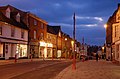 At Dusk
 -

-

-

-


English: See:Category:High Street, Daventry
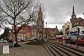
Market Square
edit-

-
 Market Day c1970s
 -
-

-

-

-


English: See:Category:Market Square, Daventry
Sheaf Street
edit-

-

-
 The Gazebo
 -

-
 Post Office
 -

-


.jpg)

English: See:Category:Sheaf Street, Daventry
New Street
edit


English: See:Category:New Street, Daventry
Bowen Square
edit


English: See:Category:Bowen Square, Daventry
Brook Street
edit_.jpg)
.jpg)


English: See:Category:Brook Street, Daventry
St James Street
edit-

-

-
 School Gates
 -

-
-

-


English: See:Category:St James Street, Daventry
London Road
edit


English: See:Category:London Road, Daventry
Church Walk
edit-

-
-

-
 Beech Grove Villas, now demolished
 -
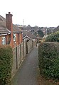 Path from Church Walk to Inlands Rise
 -

-


English: See:Category:Church Walk, Daventry
North Street
edit


English: See:Category:North Street, Daventry
Foundry Place
edit


English: See:Category:Foundry Place, Daventry
Badby Road
edit


English: See:Category:Badby Road, Daventry
Monuments and memorials
editBurton Memorial
edit52°15′30.3″N 1°09′38.1″W / 52.258417°N 1.160583°W

English: See:Category:Burton Memorial, Daventry
War Memorial
edit52°15′33.4″N 1°09′27.9″W / 52.259278°N 1.15775°W

Twin town commemoration plaques
edit52°15′20.5″N 1°09′43.6″W / 52.255694°N 1.162111°W
