East Boldon Metro station
metro station in Tyne & Wear, England, UK
English: East Boldon 54°56′47″N 1°25′13″W / 54.9464°N 1.4202°W is a station on the Green Line of the Tyne and Wear Metro.
| Opened | New or converted |
Number of platforms | Track alignment | Tyne & Wear metropolitan borough |
| 31 March 2002 | Converted | 2 | NW-SE | South Tyneside |
| Layout | ||||
| Two side platforms on an embankment, the northern one 50' longer at its northern end | ||||
| Platform no. and position |
Direction of travel M |
Previous stop |
Route | Next stop |
| Platform 1 North East |
SE bound | Brockley Whins | Green Line to South Hylton (stop 22 of 31) | Seaburn |
| Platform 2 South West |
NW bound | Seaburn | Green Line to Airport (stop 10 of 31) | Brockley Whins |
| Notes | ||||
| * M - these are compass headings, which in this station's case do not correspond to the directions diagrammatically indicated on the official Metro route map archive copy at the Wayback Machine - NW bound is Westbound & SE bound is Eastbound on the Metro map | ||||
| Station buildings | ||||
| No building (two central single sided shelters only) | ||||
| Access | ||||
| Steps and sloped paths down to a pedestrian subway 25' north of the platform end, with track level paths also extending to a level crossing for the SW-NE Station Road, 25' further beyond the subway; car park on the north side, off Station Road | ||||
| Protection from the elements | ||||
| Two standalone 65' platform shelters | ||||
| Interchanges | ||||
| car | ||||
-
 The view from the front of Metrocar No. 4089 as it approaches Platform 1, looking across the Station Road level crossing
10 October 2005 -
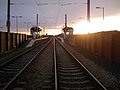 The pedestrian view of the station from the Station Road level crossing
4 December 2005 -
 A heavily processed view of Platform 2 and a train bound for Airport station
23 May 2007


