Edinburgh Trams: track & infrastructure
Track
editLayout
edit-
 diagram of the main line and depot spur (but not tracks within the depot)
 -
 map of the track within the depot site
.jpg)
Route
editSee:
Track type
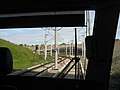
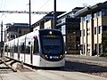
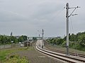
editThe Edinburgh system uses both permanent way & street running - there is a single transition point 55°56′42″N 3°13′18″W / 55.945°N 3.22153°W in the Haymarket Yards area (immediately east of the siding), where the track enters Haymarket Yards, the street (see track diagram). Everything west of this point is permanent way (except level crossings), everything east of it is street running. The permanent way features a mixture of ballast, concrete and landscaped trackbed. A portion of the permanent way was re-used from the former West Edinburgh Busway.
Permanent way
edit-
 ballast (airport straight)
 -
 ballast (airport straight)
 -
 concrete (Ingliston)
 -
 landscaped (Gogarburn)
 -
 landscaped/concrete (depot straight)
 -
 concrete (depot spur)
 -
 concrete (depot spur)
 -
 landscaped (A8 underpass)
 -
 landscaped (Gyle Centre)
 -
 landscaped (Edinburgh Park)
 -
 landscaped (Edinburgh Park)
 -
 concrete (Edinburgh Park bridge)
 -
 ballast (Bankhead Drive)
 -
 concrete (ex-busway) (Broomhouse Drive)
 -
 concrete (ex-busway) (Stenhouse Drive)
 -
 concrete/ballast (Saughton golf course)
 -
 ballast (Balgreen)
 -
 concrete (Murrayfield elevated section)
 -
 concrete (Murrayfield elevated section)
 -
 concrete (Haymarket Yards siding)
 -
 concrete (Haymarket Yards siding)
.jpg)
.jpg)
.jpg)
.jpg)
.jpg)
.jpg)
.jpg)
_(geograph_4326344).jpg)
.jpg)
.jpg)
.jpg)
.jpg)
.jpg)
.jpg)
.jpg)
.jpg)
.jpg)
.jpg)
.jpg)
.jpg)

Transition point
edit-
 An eastbound tram just about to enter the street running section
.jpg)
Street running
edit-
 concrete (Haymarket Yards)
 -
 tarmac (Haymarket)
 -
 tarmacced (Coates Place/Atholl Terrace)
 -
 block paving (Shandwick Place)
 -
 tarmacced (Princes Street)
 -
 tarmacced (Princes Street)
 -
 block paving (Waverley curve)
 -
 mixed (St Andrew Square)
 -
 concrete (York Place)
 -
 concrete (York Place)
 -
 block paving (York Place curve)
.jpg)

.jpg)
.jpg)
.jpg)

.jpg)
.jpg)
.jpg)

.jpg)
End of the line
editAt the western terminus, the line physically ends at buffer stops at the end of both platforms in the stop (Edinburgh Airport). At the eastern terminus (York Place), there is a short section of single track beyond the platform (having been reduced to one just before entering the platform), which then physically ends at a buffer stop.
-

-
 Airport buffer stop
 -

-
 York Place buffer stop
.jpg)

.jpg)
.jpg)
Signals
editStops
edit- Note - the Haymarket siding, and the crossovers at Edinburgh Park and Shandwick place, are presumably only used in emergencies or for untimetabled extra services, since there are no timetabled journeys which require their use (either to run any timetabled service, or to get a tram into position to run a timetabled service).
A diamond crossover sited immediately south of the Airport terminus (i.e. north-south aligned). Since the airport stop features two platforms with buffer stops at their northern end, this feature allows trams to enter and leave to/from either platform to/from the up/down lines.
-
 From the platforms (north)
 -
 From the north
 -
 From the south
 -
 From the south

.jpg)
.jpg)
.jpg)
A single crossover immediately to the east of Edinburgh Park Station tram stop - see note above on usage.
-
 Looking east from the mainline station footbridge
 -
 Looking east through the tram stop

.jpg)
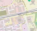
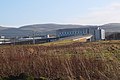
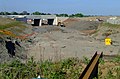
Depot spur & junctions
edit- For images inside the depot site, see Gogar Tram Depot.
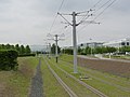
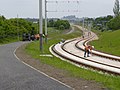
Rail access to the depot is via one of two ways, either from a single set of points off of the eastbound track of the mainline (which runs along the southern boundary of the site), or via a double-tracked spur which leaves the mainline just north of the A8 underpass ot enter the site from the east. The depot spur is presumably needed to run timetabled services, since its the shortest positioning route for trams starting eastbound journeys and terminating westbound journeys at Gyle Centre. There is a diamond crossover on the depot spur just before the depot perimeter - this presumably allows extra flexibility in the way trams enter or leave the depot. On the southern access route, there is a single crossover just east of the south side access point - this appears to be for emergency use only - it's not required to get a tram into position to run any timetabled journey (by contrast, trams terminating at Airport will presumably run to the depot out of service and enter via the single point).
-
 depot site and access tracks
 -
 the view west, showing the mainline on the left, with the southern crossover/point in the distance
 -
looking east along the mainline, with the depot on the left
-
 driver's eye view approaching the double-junction from the south, through the A8 underpass
 -
the double-junction from the south (main line left, depot spur right), from the level of the A8
-
 the view east from Myreton Drive bridge over the diamond crossing and along the depot spur (site of the future Edinburgh Gateway stop top right)
.jpg)
.jpg)
.jpg)
.jpg)
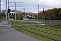
The only siding on the tram system outside the depot is in the Haymarket Yards area, west of Haymarket stop. It's on the north side of the eastbound track, but single crossovers positioned beyond each end of it allow access to/from the siding to/from either direction - see note above on usage.
-

-
 The eastern crossover, from the east
 -
Looking west across the points and siding
-
 Looking west along the siding
 -
 Eastbound tram crosses the eastern point
 -
Looking east along the siding
-
 Looking east along the siding
 -
 Looking west, showing the proximity of the Tesco Bank building/Haymarket Yards street to the siding (left).
.jpg)
.jpg)
.jpg)
.jpg)
.jpg)
.jpg)
A single crossover in Shandwick Place, to the west of West End - Princes Street stop - see note above on usage.
-
-
From the west
.jpg)
A set of points which reduces the line from a double to a single-track immediately to the west of the York Place tram stop (which is then fed into the single platform in the stop), facilitating the transfer of trams from the eastbound (northern) to the westbound (southern) track. A second set of points has also been fitted which almost makes it look like a conventional crossover (presumably with an eye to the original plan to run the line beyond this point), but the rails for the non-platform track simply end in the street before even reaching the station. They are presumably not functional points at all, since any activation, even accidental, would see a tram running off along the street (since no buffer stop has been provided).
-

-
 From the west
 -
 From the stop (east)
 -
 From the east (end of the dummy track)
.jpg)
.jpg)
.jpg)
.jpg)
Bridges
editBridges carrying the tram line
editSingle-span
editThe E-W bridge across the Gogar Burn (stream), directly north of Gogarburn tram stop.
-
 (far right)
 -
 north side
_(OSM_standard,_zoom_16).jpg)
.jpg)
The E-W bridge across South Gyle Access (road), immediately to the east of Bankhead stop, built alongside (parallel to) the pre-existing mainline railway bridge to the north.
-
-
 south side
.jpg)
.jpg)
The E-W bridge across Broomhouse Road (B701), built alongside (parallel to) the pre-existing mainline railway bridge to the north. One of the two bridges originally built to carry the West Edinburgh Busway and then converted for the tram line.
-

-
 south side
_(OSM_standard,_zoom_16).jpg)

The E-W bridge across Saughton Road, immediately to the east of Saughton stop, built alongside (parallel to) the two pre-existing mainline railway bridges to the north. One of the two bridges originally built to carry the West Edinburgh Busway and then converted for the tram line.
-

-
 south side
 -
 north side
.jpg)
.jpg)
.jpg)
The SW-NE bridge at the south west corner of Carrick Knowe golf course, that takes the tram line diagonally across the E-W mainline railway to transition it from running along its southern side (from the west) to its northern side (to the east). It incorporates a footpath along its northern edge. Immediately to the west is another footbridge, running N-S across the railway (to Carrick Knowe Avenue)
-

-
 west side, from Carrick Knowe Avenue footbridge
 -
 track view (eastbound)
_(OSM_standard,_zoom_16).jpg)
.jpg)
.jpg)
The E-W bridge across Balgreen Road, immediately to the east of Balgreen stop, built alongside (parallel to) the two pre-existing mainline railway bridges to the south.
-

-
 north side
.jpg)
.jpg)
The E-W bridge across the Water of Leith (stream/river), built alongside (parallel to) the two pre-existing mainline railway bridges to the south.
_(OSM_standard,_zoom_16).jpg)
The E-W bridge across Roseburn Street near the south east corner of Murrayfield Stadium, part of the elevated section serving the Murrayfield Stadium stop, built alongside (parallel to) the multiple mainline railway bridges to the south (carrying mainline tracks and a spur to Haymarket Depot).
-

-
 north side
 -
track view
.jpg)
.jpg)
The E-W bridge across Russell Road, part of the elevated section serving the Murrayfield Stadium stop, built alongside (parallel to) the multiple mainline railway bridges to the south.
-
 (centre left)
 -
 road view (looking south)
_(OSM_standard,_zoom_16).jpg)
.jpg)
Lochside Crescent (Edinburgh Park/Hermiston Gait)
editThe long sweeping bridge which takes the tram line in a 90 degree turn over the mainline railway and Lochside Crescent as it transitions from running westbound from Edinburgh Park Station stop to head north to Edinburgh Park Central stop. It's overlooked by the Novotel Edinburgh Park, sited on the outside of the curve.
-

-
 Looking north
 -
 Looking north (from Novotel Edinburgh Park)
 -
 Looking south
 -
 Looking west (from Edinburgh Park mainline station bridge)
 -
 Looking west (from Edinburgh Park mainline station bridge)
.jpg)
.jpg)
.jpg)
.jpg)
.jpg)
.jpg)
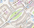
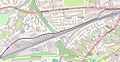
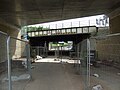
Gogar Roundabout bridge & underpass
editThere are only two places on the line where the tram track goes underneath another structure - one road bridge (Myreton Drive) and one road underpass (A8 Glasgow Road) - both are in close proximity to the depot site, on the north and east sides of the Gogar Roundabout respectively.
-
 Map of the depot site and Gogar Roundabout
.jpg)
The double-span bridge that takes Myreton Drive north from Gogar Roundabout over the E-W running tram main line and depot spur (Myreton Drive being the depot access road).
-
 west (depot) side
 -
 east side
 -
 east side
 -
 road level
.jpg)
.jpg)
.jpg)
.jpg)
The underpass which takes the tram line north underneath the E-W running A8 Glasgow Road, immediately east of the Gogar Roundabout.
-
 south side
 -
 north side

.jpg)
East Field Avenue (Airport)
editAllows East Field Avenue in the airport complex to run E-W across the final tram line straight north to the Airport terminus.
-
 (upper middle)
 -
 looking north (track view)
 -
 looking south (track view)
 -
 looking east (road view)
_(OSM_standard,_zoom_16).jpg)
.jpg)
.jpg)
.jpg)
Road to Gogar Cabinet Works (off the A8 Glasgow Road)
editAllows a local road to head north across the E-W running tram line immediately east of the E-W aligned Gogarburn stop.
.jpg)
Road to Castle Gogar (off the A8 Glasgow Road)
editAllows a local road to head north across the E-W running tram line at a point immediately west of the depot perimeter.
-
-
looking west (track view)
Allows the tram line to (diagonally) cross South Gyle Broadway as it heads south from Gyle Centre stop.
-

-
 looking north (track view)
 -
looking south (track view)
-
 Looking west (road view)
.jpg)
.jpg)
.jpg)
Lochside Avenue (Edinburgh Park)
editAllows Lochside Avenue, the access road into the northern part of Edinburgh Park business park, to cross the N-S running tram line as it heads south to Edinburgh Park Central stop.
-
 (upper middle)
 -
looking north (track view)
_(OSM_standard,_zoom_16).jpg)
Signs
editPower supply
editSubstations
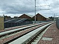
editThe system is powered by 6 electricity sub-stations - 1 is in the depot, the other 5 are on the line, at Ingliston, Bankhead, Balgreen, Haymarket (underground) and York Place (top end of Cathedral Lane).
-
 Bankhead
 -
Balgreen
.jpg)