File:"Yamdrog Tsho" (Yamdrok Tso) 1954 Tibet map sheet, from- Txu-oclc-10552568-nh46-13 (cropped).jpg

Size of this preview: 789 × 600 pixels. Other resolutions: 316 × 240 pixels | 632 × 480 pixels | 1,011 × 768 pixels | 1,280 × 973 pixels | 2,560 × 1,945 pixels | 4,207 × 3,197 pixels.
Original file (4,207 × 3,197 pixels, file size: 3.76 MB, MIME type: image/jpeg)
Captions
Captions
Add a one-line explanation of what this file represents
Summary edit
| Description |
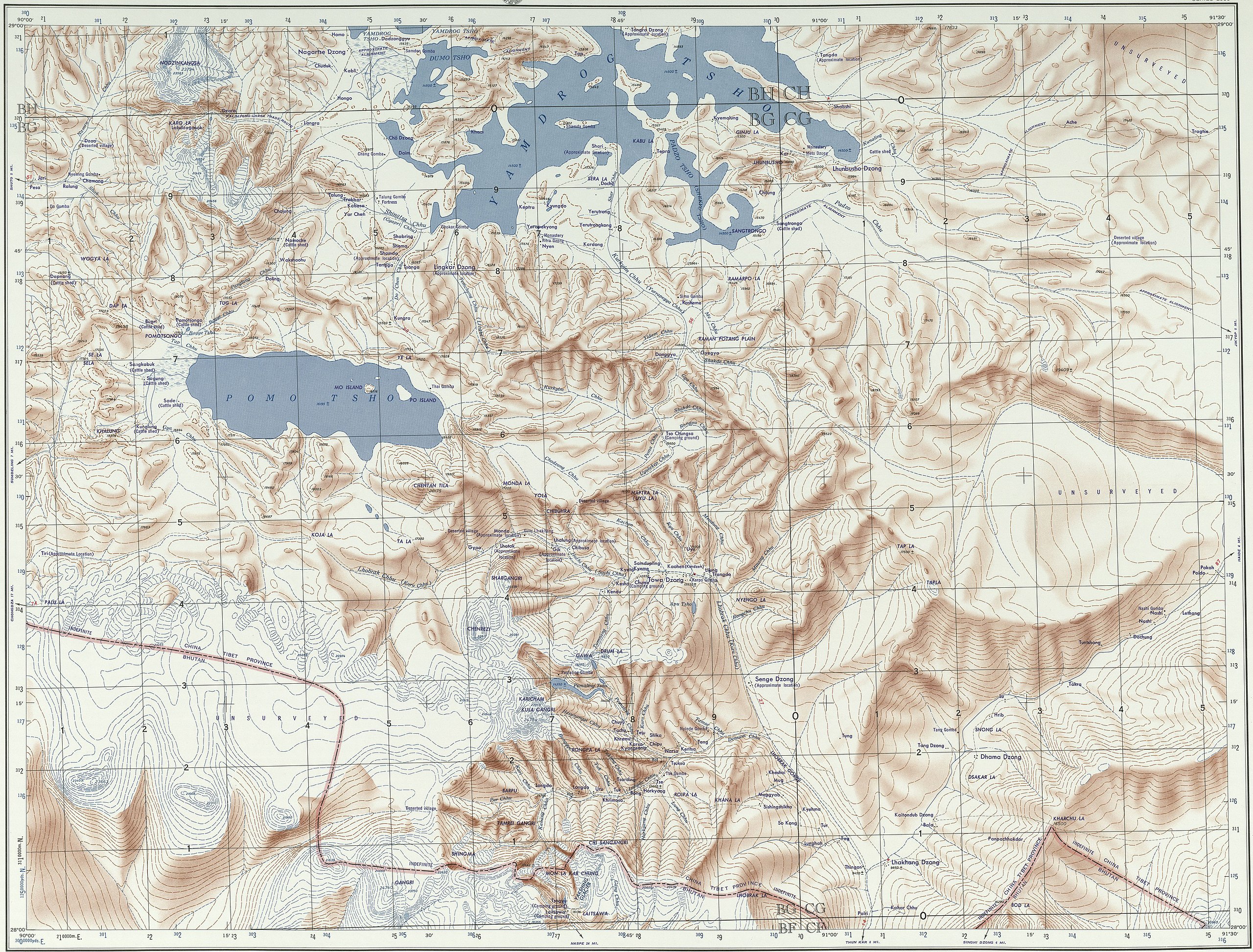
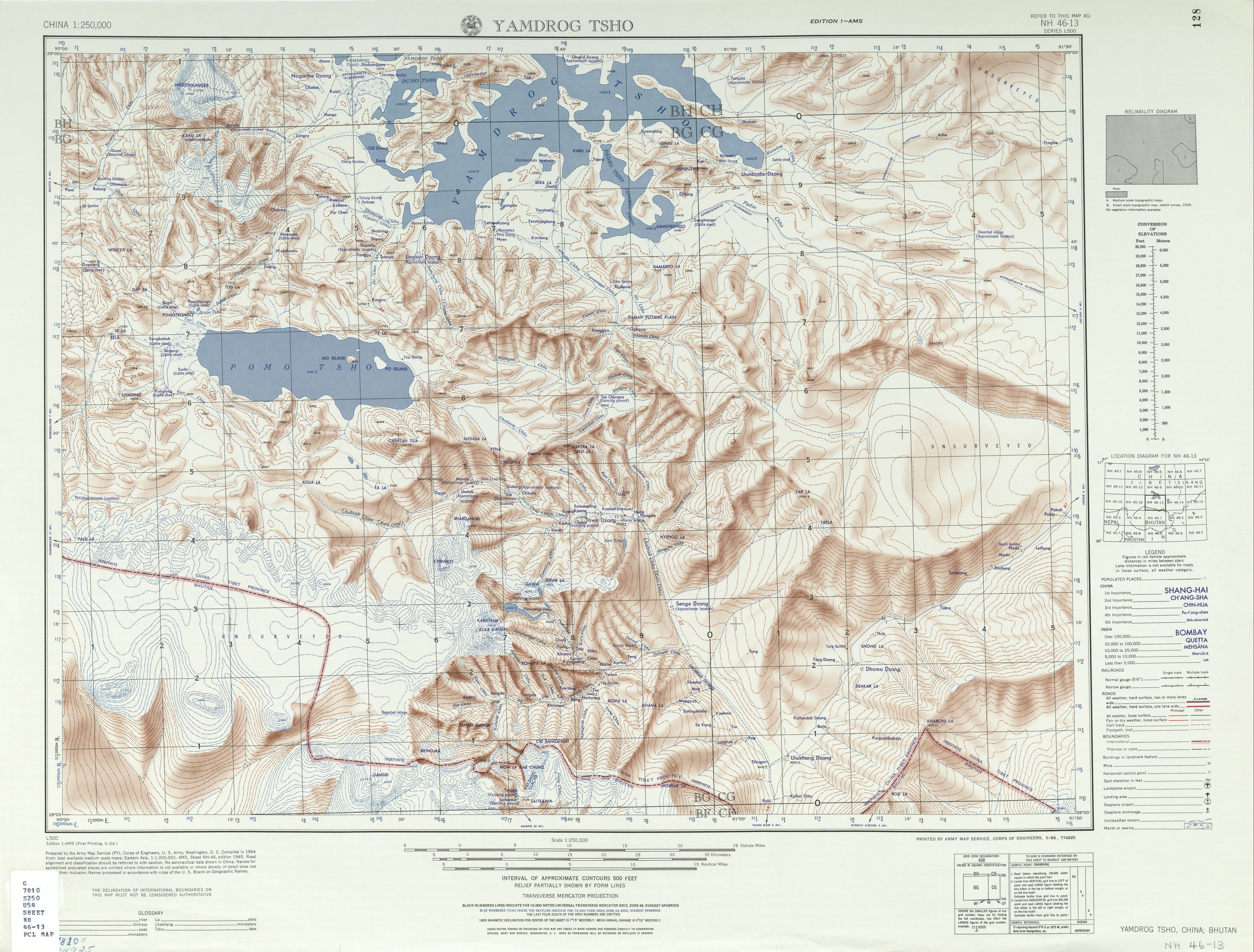
English: Map of Yamdrok Lake (Yamdrog Tsho) area, Tibet |
| Date | |
| Source | http://legacy.lib.utexas.edu/maps/ams/china/txu-oclc-10552568-nh46-13.jpg |
| Author | Army Map Service (PV), Corps of Engineers 1954 |
| Other versions |
|


-
 Index Map

_1954_Tibet_map_sheet,_from-_Txu-oclc-10552568-nh46-13_(cropped).jpg&action=edit§ion=1)
Licensing edit
_1954_Tibet_map_sheet,_from-_Txu-oclc-10552568-nh46-13_(cropped).jpg&action=edit§ion=2)
This work is in the public domain in the United States because it is a work prepared by an officer or employee of the United States Government as part of that person’s official duties under the terms of Title 17, Chapter 1, Section 105 of the US Code.
Note: This only applies to original works of the Federal Government and not to the work of any individual U.S. state, territory, commonwealth, county, municipality, or any other subdivision. This template also does not apply to postage stamp designs published by the United States Postal Service since 1978. (See § 313.6(C)(1) of Compendium of U.S. Copyright Office Practices). It also does not apply to certain US coins; see The US Mint Terms of Use.
|
 | |
| This file has been identified as being free of known restrictions under copyright law, including all related and neighboring rights. | ||
| Annotations | This image is annotated: View the annotations at Commons |
_1954_Tibet_map_sheet,_from-_Txu-oclc-10552568-nh46-13_(cropped).jpg)
File history
Click on a date/time to view the file as it appeared at that time.
| Date/Time | Thumbnail | Dimensions | User | Comment | |
|---|---|---|---|---|---|
| current | 21:08, 8 July 2020 | | 4,207 × 3,197 (3.76 MB) | Tibet Nation (talk | contribs) | File:Txu-oclc-10552568-nh46-13.jpg cropped 16 % horizontally, 16 % vertically using CropTool with lossless mode. |
You cannot overwrite this file.
File usage on Commons
The following 2 pages use this file:
_1954_Tibet_map_sheet,_from-_Txu-oclc-10552568-nh46-13_(cropped).jpg&oldid=732781956)