File:Åland2topo.png

Original file (861 × 494 pixels, file size: 148 KB, MIME type: image/png)
Captions
Captions
Summary edit
| Description |
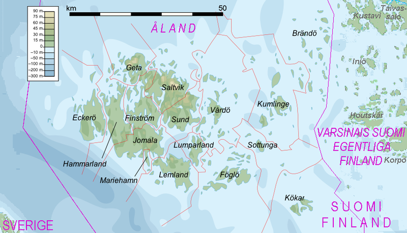
English: Topographic map of the Åland Islands.
Suomi: Ahvenanmaan topografinen kartta. |
| Date | |
| Source |
Self-made in Inkscape. |
| Author | Mysid, westerly and easterly additions by Ulamm 01:01, 16 March 2008 (UTC) |
Licensing edit

|
Permission is granted to copy, distribute and/or modify this document under the terms of the GNU Free Documentation License, Version 1.2 or any later version published by the Free Software Foundation; with no Invariant Sections, no Front-Cover Texts, and no Back-Cover Texts. A copy of the license is included in the section entitled GNU Free Documentation License. |
- You are free:
- to share – to copy, distribute and transmit the work
- to remix – to adapt the work
- Under the following conditions:
- attribution – You must give appropriate credit, provide a link to the license, and indicate if changes were made. You may do so in any reasonable manner, but not in any way that suggests the licensor endorses you or your use.
- share alike – If you remix, transform, or build upon the material, you must distribute your contributions under the same or compatible license as the original.
Licensing for the additions edit
- You are free:
- to share – to copy, distribute and transmit the work
- to remix – to adapt the work
- Under the following conditions:
- attribution – You must give appropriate credit, provide a link to the license, and indicate if changes were made. You may do so in any reasonable manner, but not in any way that suggests the licensor endorses you or your use.
- share alike – If you remix, transform, or build upon the material, you must distribute your contributions under the same or compatible license as the original.
File history
Click on a date/time to view the file as it appeared at that time.
| Date/Time | Thumbnail | Dimensions | User | Comment | |
|---|---|---|---|---|---|
| current | 13:53, 17 March 2008 | | 861 × 494 (148 KB) | Ulamm (talk | contribs) | |
| 11:07, 16 March 2008 |  | 861 × 494 (148 KB) | Ulamm (talk | contribs) | ||
| 10:59, 16 March 2008 |  | 861 × 494 (148 KB) | Ulamm (talk | contribs) | ||
| 01:01, 16 March 2008 |  | 861 × 494 (149 KB) | Ulamm (talk | contribs) | |Description={{en|Topographic map of the Åland Islands.}} {{fi|Ahvenanmaan topografinen kartta.}} |Source=Self-made in Inkscape.<br/>Boundaries and municipality borders based on Image:Alandmunicipalities.png |
You cannot overwrite this file.
File usage on Commons
There are no pages that use this file.
File usage on other wikis
The following other wikis use this file:
- Usage on af.wikipedia.org
- Usage on dsb.wikipedia.org
- Usage on es.wikipedia.org
- Usage on et.wikipedia.org
- Usage on frr.wikipedia.org
- Usage on gl.wikipedia.org
- Usage on he.wikipedia.org
- Usage on hsb.wikipedia.org
- Usage on nl.wikipedia.org
- Usage on no.wikipedia.org
- Usage on pl.wikipedia.org
- Usage on pl.wikivoyage.org
- Usage on pl.wiktionary.org
- Usage on th.wikipedia.org
- Usage on zea.wikipedia.org