File:Çukurca attack.png

Size of this preview: 776 × 600 pixels. Other resolutions: 311 × 240 pixels | 621 × 480 pixels | 994 × 768 pixels | 1,056 × 816 pixels.
Original file (1,056 × 816 pixels, file size: 25 KB, MIME type: image/png)
Captions
Captions
Add a one-line explanation of what this file represents
Summary
edit
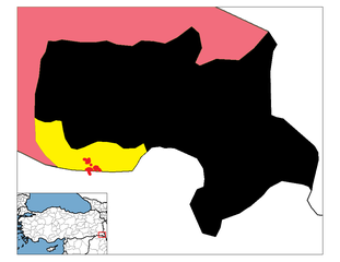
| Description | Location of Çukurca attack of PKK terrorists / guerillas on 19 October 2011, which killed 24 Turkish soldiers. |
| Date | (UTC) |
| Source | |
| Author |
|
| This is a retouched picture, which means that it has been digitally altered from its original version. Modifications: Highlighted location. The original can be viewed here: Hakkari districts.png:
|
Licensing
edit
I, the copyright holder of this work, hereby publish it under the following license:
| I, the copyright holder of this work, release this work into the public domain. This applies worldwide. In some countries this may not be legally possible; if so: I grant anyone the right to use this work for any purpose, without any conditions, unless such conditions are required by law. |
Original upload log
edit
This image is a derivative work of the following images:
- File:Hakkari_districts.png licensed with PD-self
- 2008-12-28T22:35:59Z One Homo Sapiens 1056x816 (20974 Bytes) Corrected text where İ,Ş,ı,ğ,or ş occurs in name. Source: [statoids-com]. Increased font size and enhanced color differences among adjacent districts. Restored original dimensions.
- 2007-10-28T00:06:33Z とある白い猫 948x770 (38493 Bytes) removing whitespace
- 2007-10-22T13:04:07Z とある白い猫 1056x816 (44961 Bytes) adding neigboring countries
- 2007-10-22T13:01:07Z とある白い猫 1056x816 (43783 Bytes) increasing text size
- 2006-12-01T20:56:55Z Rarelibra 1056x816 (24251 Bytes) Map of the districts of Hakkari province in Turkey. Created by ~~~~ for public domain use, using MapInfo Professional v8.5 and various mapping resources.
Uploaded with derivativeFX
File history
Click on a date/time to view the file as it appeared at that time.
| Date/Time | Thumbnail | Dimensions | User | Comment | |
|---|---|---|---|---|---|
| current | 21:00, 19 October 2011 | | 1,056 × 816 (25 KB) | Seksen iki yüz kırk beş (talk | contribs) | == {{int:filedesc}} == {{Information |Description=Location of Çukurca attack of PKK terrorists / guerillas on 19 October 2011, which killed 24 Turkish soldiers. |Source=*File:Hakkari_districts.png |Date=2011-10-19 20:59 (UTC) |Author=*[[:File:Hakka |
You cannot overwrite this file.
File usage on Commons
There are no pages that use this file.
File usage on other wikis
The following other wikis use this file:
- Usage on incubator.wikimedia.org
- Usage on tr.wikinews.org
- Usage on www.wikidata.org