File:Östliches Amöneburger Becken.jpg

Size of this preview: 798 × 152 pixels. Other resolutions: 320 × 61 pixels | 640 × 122 pixels | 1,024 × 195 pixels | 4,494 × 856 pixels.
Original file (4,494 × 856 pixels, file size: 310 KB, MIME type: image/jpeg)
Captions
Captions
Add a one-line explanation of what this file represents
Summary edit
| Description |
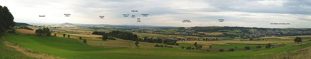
Deutsch: Blick vom Rand des Lumda-Plateaus oberhalb Gontershausens auf das östliche Amöneburger Becken (Ohmtalsenke) mit Amöneburg (365m), Burgholz (380m) und Kellerwald mit (vlnr im Hintergrund), Hohem Lohr (657m), Jeust (585m) und Wüstegarten (675m); rechts das Nördliche Vogelsberg-Vorland mit Hochberg (358m) und der Stadt Homberg (Ohm). Bahnstrecke (Ohmtalbahn) am Basaltwerk Nieder-Ofleiden in der relativ flachen Landschaft bei Homberg (Ohm) (2008). |
| Date | |
| Source | Eigenes Werk (own work) von 50.7273°N 8.96043°E (ca. 340m) |
| Author | Elop |
| Camera location | | View this and other nearby images on: OpenStreetMap |
|---|
Licensing edit
I, the copyright holder of this work, hereby publish it under the following licenses:

|
Permission is granted to copy, distribute and/or modify this document under the terms of the GNU Free Documentation License, Version 1.2 or any later version published by the Free Software Foundation; with no Invariant Sections, no Front-Cover Texts, and no Back-Cover Texts. A copy of the license is included in the section entitled GNU Free Documentation License. |
This file is licensed under the Creative Commons Attribution-Share Alike 3.0 Unported license.
- You are free:
- to share – to copy, distribute and transmit the work
- to remix – to adapt the work
- Under the following conditions:
- attribution – You must give appropriate credit, provide a link to the license, and indicate if changes were made. You may do so in any reasonable manner, but not in any way that suggests the licensor endorses you or your use.
- share alike – If you remix, transform, or build upon the material, you must distribute your contributions under the same or compatible license as the original.
You may select the license of your choice.
File history
Click on a date/time to view the file as it appeared at that time.
| Date/Time | Thumbnail | Dimensions | User | Comment | |
|---|---|---|---|---|---|
| current | 09:05, 10 January 2019 | 4,494 × 856 (310 KB) | Elop (talk | contribs) | minus 2*f | |
| 09:35, 12 August 2008 | 4,494 × 856 (259 KB) | Elop (talk | contribs) | {{Information |Description= |Source= |Date= |Author= |Permission= |other_versions= }} | ||
| 12:08, 9 August 2008 | 4,494 × 856 (246 KB) | Elop (talk | contribs) | {{Information |Description= |Source= |Date= |Author= |Permission= |other_versions= }} | ||
| 12:05, 9 August 2008 | 4,494 × 856 (252 KB) | Elop (talk | contribs) | {{Information |Description= |Source= |Date= |Author= |Permission= |other_versions= }} | ||
| 10:59, 9 August 2008 | 4,494 × 856 (265 KB) | Elop (talk | contribs) | {{Information |Description={{de|1=Blick vom Rand des Lumda-Plateaus oberhalb Gontershausens auf das östliche Amöneburger Becken (Ohmtalsenke) mit Amöneburg, Burgholz und Kellerwald}} |Source=Eigenes Werk (own work) |Author=Elop |Date=01.0 |
You cannot overwrite this file.
File usage on Commons
The following 3 pages use this file:
File usage on other wikis
The following other wikis use this file:
- Usage on de.wikipedia.org