File:Ötztaler Alpen Map.png

Size of this preview: 571 × 599 pixels. Other resolutions: 229 × 240 pixels | 458 × 480 pixels | 732 × 768 pixels | 976 × 1,024 pixels | 1,952 × 2,048 pixels | 4,710 × 4,941 pixels.
Original file (4,710 × 4,941 pixels, file size: 5.42 MB, MIME type: image/png)
Captions
Captions
Add a one-line explanation of what this file represents
| Description |
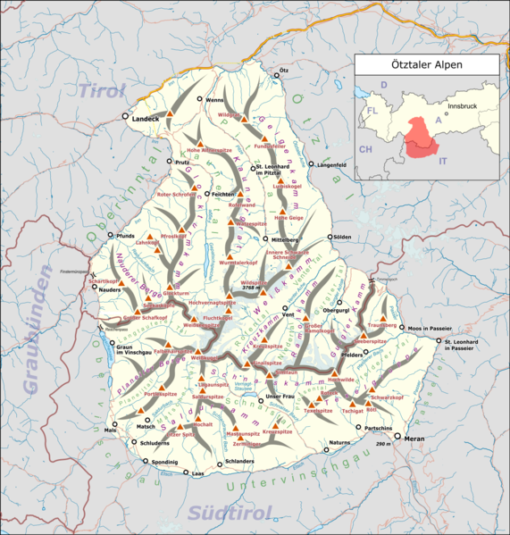
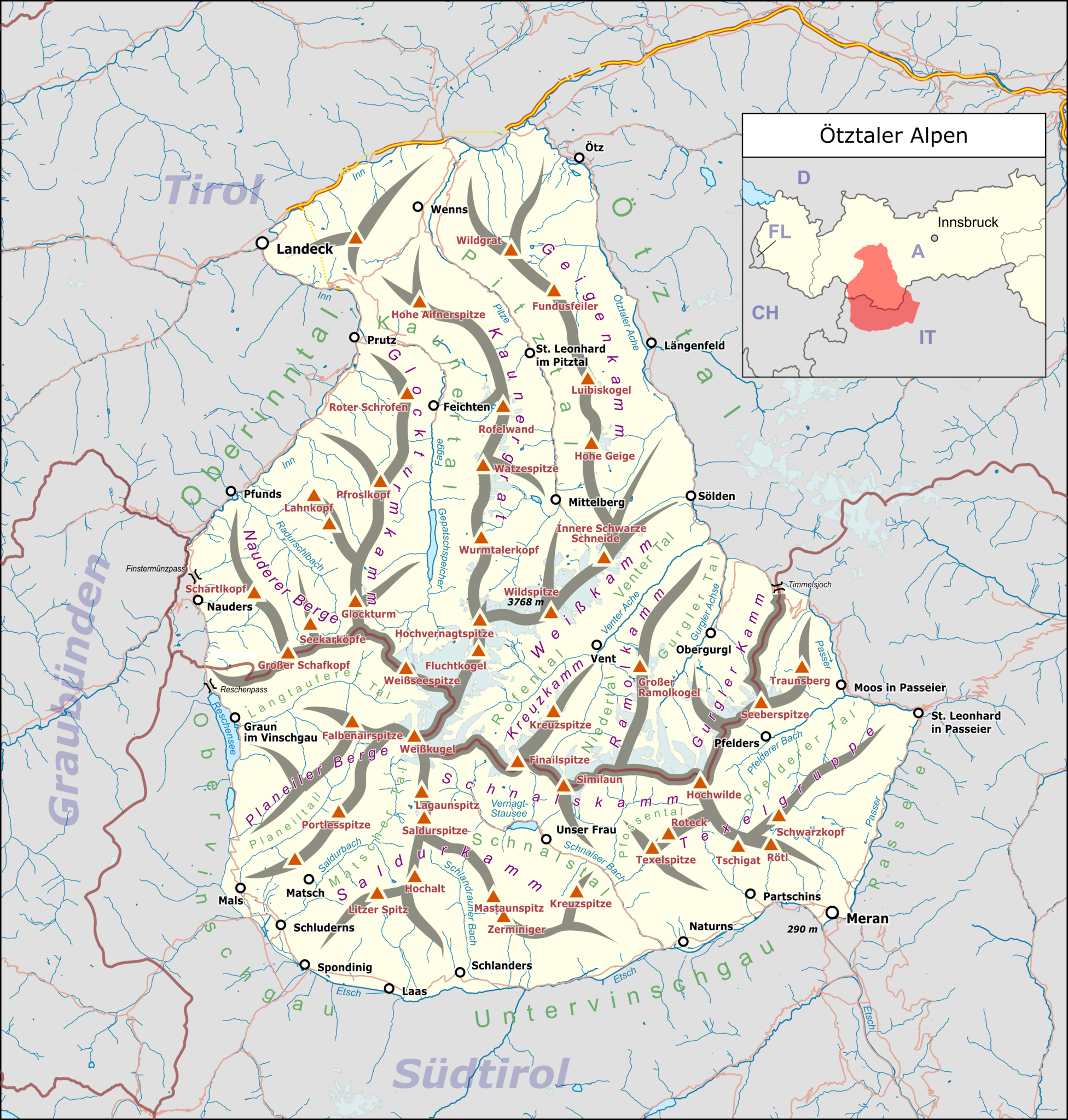
Deutsch: Übersichtskarte der Ötztaler Alpen. |
|||||||||
| Date | ||||||||||
| Source |
Own work Map was created using:
|
|||||||||
| Creator |
|
|||||||||
| Permission (Reusing this file) |
Map data (c) OpenStreetMap (and) contributors, CC-BY-SA | |||||||||
| Geotemporal data | ||||||||||
| Bounding box |
|
|||||||||
| Georeferencing | ||||||||||
This file is licensed under the Creative Commons Attribution-Share Alike 2.0 Generic license.
- You are free:
- to share – to copy, distribute and transmit the work
- to remix – to adapt the work
- Under the following conditions:
- attribution – You must give appropriate credit, provide a link to the license, and indicate if changes were made. You may do so in any reasonable manner, but not in any way that suggests the licensor endorses you or your use.
- share alike – If you remix, transform, or build upon the material, you must distribute your contributions under the same or compatible license as the original.
File history
Click on a date/time to view the file as it appeared at that time.
| Date/Time | Thumbnail | Dimensions | User | Comment | |
|---|---|---|---|---|---|
| current | 12:12, 28 January 2021 | | 4,710 × 4,941 (5.42 MB) | Pechristener (talk | contribs) | ergänzt mit Label "St. Leonhard im Pitztal" |
| 00:36, 3 May 2018 |  | 5,024 × 5,270 (5.69 MB) | Pechristener (talk | contribs) | Korrekturen von User Mai-Sachme gemäss Disk eingepflegt | |
| 08:59, 26 August 2017 |  | 5,024 × 5,270 (5.7 MB) | Pechristener (talk | contribs) | Lage vom Reschenpass korrigiert | |
| 08:39, 26 August 2017 |  | 5,024 × 5,270 (5.7 MB) | Pechristener (talk | contribs) | verschiedene kleinere Reparaturen | |
| 01:39, 4 August 2017 |  | 5,017 × 5,263 (5.69 MB) | Pechristener (talk | contribs) | small error fix | |
| 01:36, 4 August 2017 |  | 5,017 × 5,263 (5.69 MB) | Pechristener (talk | contribs) | {{Map |Description={{de|1=Übersichtskarte der {{w|Ötztaler Alpen||de}}. }} |Source ={{own}} Map was created using: *[http://www.openstreetmap.org/ Open Street Map] Data *{{w|Austria location map.svg}} for location map |Author = *... |
You cannot overwrite this file.
File usage on Commons
The following 15 pages use this file:
- Alps
- Saldurspitze
- Texelgruppe
- Wildspitze
- User:Anton-kurt/Tyrol new files/2017 August 1-10
- User:Anton-kurt/Tyrol new files/2017 August 21-31
- User:Anton-kurt/Tyrol new files/2018 May 1-10
- User:Anton-kurt/Tyrol new files/2021 January 21-31
- User:J budissin/Uploads/BiH/2018 May 1-10
- User:Mai-Sachme/South Tyrol/2017 August 1-10
- User:Mai-Sachme/South Tyrol/2017 August 21-31
- User:Mai-Sachme/South Tyrol/2018 May 1-10
- User:Mai-Sachme/South Tyrol/2021 January 21-31
- Category:Maps of Ötztal Alps
- Category:Ötztal Alps
File usage on other wikis
The following other wikis use this file:
- Usage on bg.wikipedia.org
- Usage on cs.wikipedia.org
- Usage on de.wikipedia.org
- Wildspitze
- Kaunertal
- Similaun
- Ötztaler Alpen
- Pitztal
- Weißkugel
- Braunschweiger Hütte
- Hochwilde
- Verpeilhütte
- Gepatschferner
- Texelgruppe
- Martin-Busch-Hütte
- Grawand
- Hochjoch (Schnalskamm)
- Hochjochferner
- Ramolkogel
- Wildes Mannle
- Mittagskogel (Pitztal)
- Gurgler Tal
- Ötztaler Urkund
- Vordere Hintereisspitze
- Mittlere Hintereisspitze
- Hintere Hintereisspitze
- Langtauferer Ferner
- Karlesspitze
- Ramolhaus
- Hochwildehaus
- Langtalereckhütte
- Hochjoch-Hospiz
- Kaunergrathütte
- Stettiner Hütte
- Schöne-Aussicht-Hütte
- Liste der Gebirgsgruppen in den Ostalpen (nach AVE)
- Gaislachkogel
- Grabkogel
- Riffelseehütte
- Mutspitze (Texelgruppe)
- Gschrappkogel
- Wurmsitzkogel
- Vorlage:Positionskarte Ötztaler Alpen
- Hangerer
- Polleskogel
- Benutzer Diskussion:Pechristener/Alpenkarten
- Josef-Pixner-Biwak
- Guido-Lammer-Biwak
- Niederjoch (Schnalskamm)
- Rappenkopf (Pitztal)
- Rabenkopf (Ötztaler Alpen)
View more global usage of this file.