File:Übersichtskarte Seychellen.png
No higher resolution available.
Übersichtskarte_Seychellen.png (697 × 369 pixels, file size: 167 KB, MIME type: image/png)
Captions
Captions
Add a one-line explanation of what this file represents
| Description |
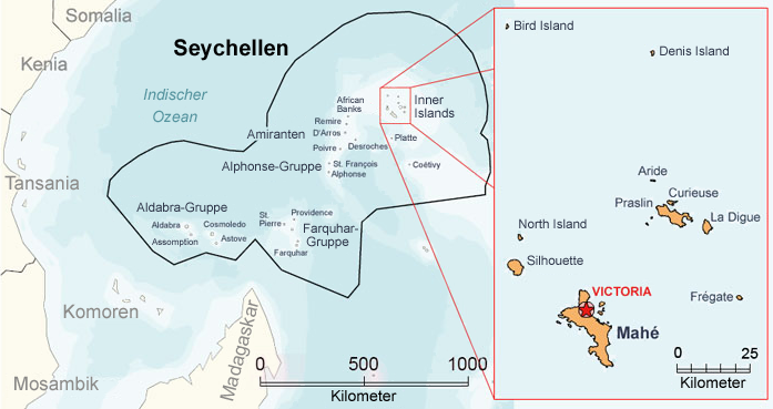
Deutsch: Karte der Seychellen
English: Map of the Seychelles |
| Date | (UTC) |
| Source | |
| Author |
|
| This is a retouched picture, which means that it has been digitally altered from its original version. Modifications: translation. The original can be viewed here: Geografia de seychelles ES.jpg:
|
I, the copyright holder of this work, hereby publish it under the following licenses:

|
Permission is granted to copy, distribute and/or modify this document under the terms of the GNU Free Documentation License, Version 1.2 or any later version published by the Free Software Foundation; with no Invariant Sections, no Front-Cover Texts, and no Back-Cover Texts. A copy of the license is included in the section entitled GNU Free Documentation License. |
This file is licensed under the Creative Commons Attribution-Share Alike 2.5 Generic, 2.0 Generic and 1.0 Generic license.
- You are free:
- to share – to copy, distribute and transmit the work
- to remix – to adapt the work
- Under the following conditions:
- attribution – You must give appropriate credit, provide a link to the license, and indicate if changes were made. You may do so in any reasonable manner, but not in any way that suggests the licensor endorses you or your use.
- share alike – If you remix, transform, or build upon the material, you must distribute your contributions under the same or compatible license as the original.
| This file is licensed under the Creative Commons Attribution-Share Alike 3.0 Unported license. | ||
| ||
| This licensing tag was added to this file as part of the GFDL licensing update. |
You may select the license of your choice.
Original upload log
edit
This image is a derivative work of the following images:
- File:Geografia_de_seychelles_ES.jpg licensed with Cc-by-sa-2.5,2.0,1.0, Cc-by-sa-2.5,2.0,1.0/de, Cc-by-sa-3.0-migrated, Cc-by-sa-3.0-migrated/de, GFDL, GFDL/de
- 2007-04-06T02:25:04Z Plaerdemavida 700x369 (48784 Bytes) Geografía de Seychelles. Principales islas y grupos de islas.
Uploaded with derivativeFX
File history
Click on a date/time to view the file as it appeared at that time.
| Date/Time | Thumbnail | Dimensions | User | Comment | |
|---|---|---|---|---|---|
| current | 15:00, 2 November 2009 | | 697 × 369 (167 KB) | NordNordWest (talk | contribs) | {{Information |Description= {{de|Karte der Seychellen}} {{en|Map of the Seychelles}} |Source=*File:Geografia_de_seychelles_ES.jpg |Date=2009-11-02 14:57 (UTC) |Author=*File:Geografia_de_seychelles_ES.jpg: |
You cannot overwrite this file.
File usage on Commons
There are no pages that use this file.
File usage on other wikis
The following other wikis use this file:
- Usage on ca.wikipedia.org
- Usage on cs.wikipedia.org
- Usage on de.wikipedia.org
- Usage on mdf.wikipedia.org
- Usage on sv.wikipedia.org