File:Ślesin (gmina) location map.png

Size of this preview: 588 × 600 pixels. Other resolutions: 235 × 240 pixels | 471 × 480 pixels | 695 × 709 pixels.
Original file (695 × 709 pixels, file size: 112 KB, MIME type: image/png)
Captions
Captions
Add a one-line explanation of what this file represents
| Description |
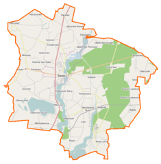
Polski: Mapa gminy Ślesin, Polska
English: Map of Gmina Ślesin, Poland |
|||||||||
| Date | ||||||||||
| Source | You may find a page on the OpenStreetMap wiki page for Ślesin (gmina) | |||||||||
| Creator |
OpenStreetMap contributors OpenStreetMap contributors |
|||||||||
| Permission (Reusing this file) |
OpenStreetMap data is available under the Open Database License (details). Map tiles are licensed under the Creative Commons Attribution-ShareAlike 2.0 license (CC-BY-SA 2.0).
This file is licensed under the Creative Commons Attribution-Share Alike 2.0 Generic license.
|
|||||||||
| Geotemporal data | ||||||||||
| Bounding box |
|
|||||||||
| Georeferencing | If inappropriate please set warp_status = skip to hide. | |||||||||
File history
Click on a date/time to view the file as it appeared at that time.
| Date/Time | Thumbnail | Dimensions | User | Comment | |
|---|---|---|---|---|---|
| current | 12:36, 9 December 2014 | | 695 × 709 (112 KB) | VanWiel (talk | contribs) | {{OpenStreetMap | name = Ślesin (gmina) | location = Ślesin (gmina) | description = {{pl|Mapa gminy Ślesin, Polska}} {{en|Map of Gmina Ślesin, Poland}} | top = 52.4389 | bottom = 52.2902 | left... |
You cannot overwrite this file.
File usage on Commons
There are no pages that use this file.
File usage on other wikis
The following other wikis use this file:
- Usage on fr.wikipedia.org
- Usage on pl.wikipedia.org
- Licheń Stary
- Ślesin
- Jezioro Ślesińskie
- Ślesin (gmina)
- Bylew
- Głębockie Pierwsze
- Honoratka (województwo wielkopolskie)
- Julia (województwo wielkopolskie)
- Kijowskie Nowiny
- Kolebki
- Lubomyśle
- Ostrowąż
- Półwiosek Lubstowski
- Kolonia Sarnowa
- Szyszyn
- Szyszyńskie Holendry
- Półwiosek Stary
- Biskupie (województwo wielkopolskie)
- Dąbrowa Duża (województwo wielkopolskie)
- Ignacewo (powiat koniński)
- Kijowiec (województwo wielkopolskie)
- Różnowo (województwo wielkopolskie)
- Wąsosze (województwo wielkopolskie)
- Żółwieniec (wieś)
- Goranin (powiat koniński)
- Kępa (powiat koniński)
- Leśnictwo (powiat koniński)
- Mikorzyn (powiat koniński)
- Niedźwiady Duże
- Piotrkowice (powiat koniński)
- Smolniki (powiat koniński)
- Wygoda (wieś w gminie Ślesin)
- Marianowo (gmina Ślesin)
- RTCN Żółwieniec
- Jezioro Mikorzyńskie
- Dzwon Maryja Bogurodzica
- Nowy Licheń
- Bazylika Najświętszej Maryi Panny Licheńskiej w Licheniu Starym
- Szyszynek
- Niedźwiady Małe
- Pogoń Gosławicka
- Pogorzele (Smolniki)
- Pogoń Lubstowska
- Sarnowa (powiat koniński)
- Wierzelin
- Konstantynowo (powiat koniński)
- Lizawy
- Florentynowo
- Łuk Napoleona w Ślesinie
View more global usage of this file.
_location_map.png)
_location_map.png&oldid=506172707)