File:Śliwice (gmina) location map.png

Size of this preview: 548 × 599 pixels. Other resolutions: 219 × 240 pixels | 439 × 480 pixels | 856 × 936 pixels.
Original file (856 × 936 pixels, file size: 102 KB, MIME type: image/png)
Captions
Captions
Add a one-line explanation of what this file represents
| Description |
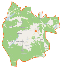
Polski: Mapa gminy Śliwice, Polska
English: Map of Gmina Śliwice, Poland |
|||||||||
| Date | ||||||||||
| Source | You may find a page on the OpenStreetMap wiki page for Śliwice (gmina) | |||||||||
| Creator |
OpenStreetMap contributors OpenStreetMap contributors |
|||||||||
| Permission (Reusing this file) |
OpenStreetMap data is available under the Open Database License (details). Map tiles are licensed under the Creative Commons Attribution-ShareAlike 2.0 license (CC-BY-SA 2.0).
This file is licensed under the Creative Commons Attribution-Share Alike 2.0 Generic license.
|
|||||||||
| Geotemporal data | ||||||||||
| Bounding box |
|
|||||||||
| Georeferencing | If inappropriate please set warp_status = skip to hide. | |||||||||
File history
Click on a date/time to view the file as it appeared at that time.
| Date/Time | Thumbnail | Dimensions | User | Comment | |
|---|---|---|---|---|---|
| current | 07:09, 20 November 2014 | | 856 × 936 (102 KB) | VanWiel (talk | contribs) | {{OpenStreetMap | name = Śliwice (gmina) | location = Śliwice (gmina) | description = {{pl|Mapa gminy Śliwice, Polska}} {{en|Map of Gmina Śliwice, Poland}} | top = 53.7846 | bottom = 53.6165 | l... |
You cannot overwrite this file.
File usage on Commons
There are no pages that use this file.
File usage on other wikis
The following other wikis use this file:
- Usage on pl.wikipedia.org
- Śliwice (gmina)
- Brzeźno (powiat tucholski)
- Brzozowe Błota
- Byłyczek
- Lińsk
- Lubocień
- Łąski Piec
- Okoniny (województwo kujawsko-pomorskie)
- Okoniny Nadjeziorne
- Rosochatka
- Śliwiczki
- Krąg (województwo kujawsko-pomorskie)
- Laski (województwo kujawsko-pomorskie)
- Linówek (województwo kujawsko-pomorskie)
- Lipowa (województwo kujawsko-pomorskie)
- Śliwice (województwo kujawsko-pomorskie)
- Zwierzyniec (powiat tucholski)
- Lisiny (gmina Śliwice)
- Główka (województwo kujawsko-pomorskie)
- Mała Główka
- Łoboda (osada)
- Kamionka (powiat tucholski)
- Jabłonka (województwo kujawsko-pomorskie)
- Zarośle (powiat tucholski)
- Śliwice (przystanek kolejowy)
- Laski Tucholskie
- Lipowa Tucholska
- Lipowa Wschodnia
- Parafia św. Katarzyny Aleksandryjskiej w Śliwicach
- Rosochatka (przystanek kolejowy)
- Zarośle (przystanek kolejowy)
- Śliwiczki (przystanek kolejowy)
- Ślepe Jezioro
- Jezioro Okonińskie
- Zazdrość (powiat tucholski)
- Niedźwiedziniec (województwo kujawsko-pomorskie)
- Zarośla (województwo kujawsko-pomorskie)
- Moduł:Mapa/dane/Śliwice (gmina)
- Kościół św. Katarzyny Aleksandryjskiej w Śliwicach
- Usage on pl.wikibooks.org
_location_map.png&oldid=507690035)