File:Брест, ДОТ у моста над Бугом 03.jpg

Size of this preview: 800 × 534 pixels. Other resolutions: 320 × 214 pixels | 640 × 427 pixels | 1,024 × 684 pixels | 1,504 × 1,004 pixels.
Original file (1,504 × 1,004 pixels, file size: 664 KB, MIME type: image/jpeg)
Captions
Captions
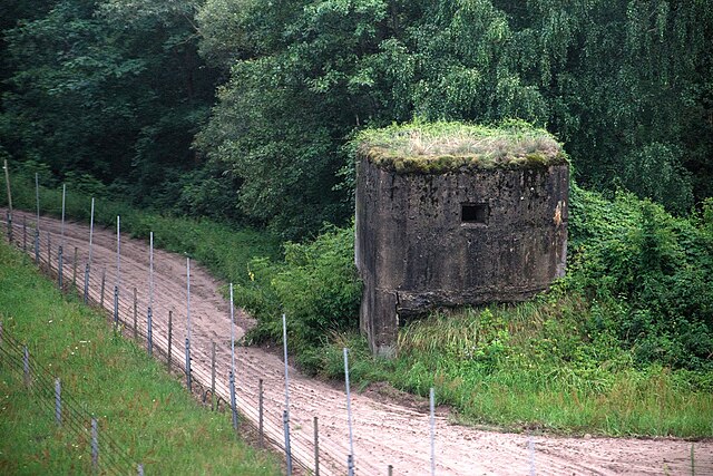
Old Soviet pillbox, security electric fence KS-185 Gobi and trace-control strip at the Belarussian-Polish border between Brest and Terespol
Summary
edit
| Description |
Русский: Пограничный дот над Западным Бугом у железнодорожного моста Брест-Тересполь |
| Date | |
| Source | Own work |
| Author | Vedenei |
| Camera location | | View this and other nearby images on: OpenStreetMap |
|---|
Licensing
edit
I, the copyright holder of this work, hereby publish it under the following license:
This file is licensed under the Creative Commons Attribution-Share Alike 4.0 International license.
- You are free:
- to share – to copy, distribute and transmit the work
- to remix – to adapt the work
- Under the following conditions:
- attribution – You must give appropriate credit, provide a link to the license, and indicate if changes were made. You may do so in any reasonable manner, but not in any way that suggests the licensor endorses you or your use.
- share alike – If you remix, transform, or build upon the material, you must distribute your contributions under the same or compatible license as the original.
File history
Click on a date/time to view the file as it appeared at that time.
| Date/Time | Thumbnail | Dimensions | User | Comment | |
|---|---|---|---|---|---|
| current | 09:07, 31 July 2018 | | 1,504 × 1,004 (664 KB) | Vedenei (talk | contribs) | User created page with UploadWizard |
You cannot overwrite this file.
File usage on Commons
There are no pages that use this file.
File usage on other wikis
The following other wikis use this file:
- Usage on cs.wikipedia.org
- Usage on ru.wikipedia.org