File:Военно-топографическая карта Росийской Империи 1917 года, ряд ХХIV, лист 4 - Тарнополь.png

Size of this preview: 797 × 600 pixels. Other resolutions: 319 × 240 pixels | 638 × 480 pixels | 1,020 × 768 pixels | 1,280 × 964 pixels | 2,560 × 1,927 pixels | 4,999 × 3,763 pixels.
Original file (4,999 × 3,763 pixels, file size: 5.63 MB, MIME type: image/png)
Captions
Captions
Add a one-line explanation of what this file represents
Summary
edit
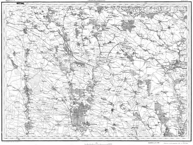
| Description |
Українська: Військово-топографічна мапа Російскої Імперії, 1917 рік, ряд XXIV, аркуш 4 (виправлена за рекогностуванням 1867-1869-1872-1874 років) — м. Тернопіль та околиця.
English: Military topographic map of the Russian Empire from 1917, row XXIV, sheet 4 made by the Military topographic depot of the General staff of the Russian army |
| Date | |
| Source | Военно-топографическая карта Российской Империи от 1917 года, ряд ХХIV, лист 4 |
| Author | Военно-топографическое депо Генерального штаба русской армии |
Licensing
edit
|
This work is in the public domain in its country of origin and other countries and areas where the copyright term is the author's life plus 70 years or fewer. This work is in the public domain in the United States because it was published (or registered with the U.S. Copyright Office) before January 1, 1929. | |
| This file has been identified as being free of known restrictions under copyright law, including all related and neighboring rights. | |
File history
Click on a date/time to view the file as it appeared at that time.
| Date/Time | Thumbnail | Dimensions | User | Comment | |
|---|---|---|---|---|---|
| current | 18:22, 2 May 2020 | | 4,999 × 3,763 (5.63 MB) | Микола Василечко (talk | contribs) | Uploaded a work by Военно-топографическое депо Генерального штаба русской армии from Военно-топографическая карта Российской Империи от 1867 года, ряд ХХIV, лист 4 with UploadWizard |
You cannot overwrite this file.
File usage on Commons
There are no pages that use this file.