File:Карта леваго фланга Кавказской линии с прилежащими землями горских народов и частями севернаго Дагестана.jpg

Size of this preview: 800 × 429 pixels. Other resolutions: 320 × 172 pixels | 640 × 343 pixels | 1,024 × 549 pixels | 1,280 × 687 pixels | 3,541 × 1,900 pixels.
Original file (3,541 × 1,900 pixels, file size: 5.28 MB, MIME type: image/jpeg)
Captions
Captions
Add a one-line explanation of what this file represents
Summary edit
| Description |
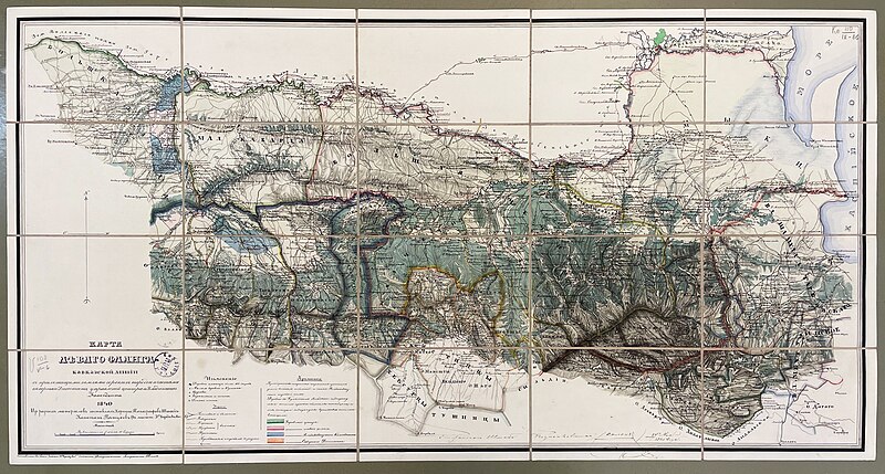
Русский: Карта леваго фланга Кавказской линии с прилежащими землями горских народов и частями севернаго Дагестана, управлений центра и Владикавказ. Коменданта: 1840 / из разных материалов составлял Корпуса топографов Штабс-капитан Петухов. – 1:420 000. — [Тифлис], 1841 . — 1 к. : цв., раскраш., рукопис. ; 46,5 × 88,5 × 0,1 см, в слож. виде: 11,5 × 17,8 × 1,0 см. |
| Date | |
| Source | из разных материалов составлял Корпуса топографов Штабс-капитан Петухов. – 1:420 000. — [Тифлис], 1841 . — 1 к. : цв., раскраш., рукопис. ; 46,5 × 88,5 × 0,1 см, в слож. виде: 11,5 × 17,8 × 1,0 см. |
| Author | Штабс-капитан Петухов |
| Camera location | | View this and other nearby images on: OpenStreetMap |
|---|
Licensing edit
|
This work is in the public domain in its country of origin and other countries and areas where the copyright term is the author's life plus 70 years or fewer. This work is in the public domain in the United States because it was published (or registered with the U.S. Copyright Office) before January 1, 1929. | |
| This file has been identified as being free of known restrictions under copyright law, including all related and neighboring rights. | |
File history
Click on a date/time to view the file as it appeared at that time.
| Date/Time | Thumbnail | Dimensions | User | Comment | |
|---|---|---|---|---|---|
| current | 16:16, 30 July 2023 | | 3,541 × 1,900 (5.28 MB) | Takhirgeran Umar (talk | contribs) | Uploaded a work by Штабс-капитан Петухов from из разных материалов составлял Корпуса топографов Штабс-капитан Петухов. – 1:420 000. — [Тифлис], 1841 . — 1 к. : цв., раскраш., рукопис. ; 46,5 × 88,5 × 0,1 см, в слож. виде: 11,5 × 17,8 × 1,0 см. with UploadWizard |
You cannot overwrite this file.
File usage on Commons
The following page uses this file: