File:Природная арка Атлеша.jpg
Original file (4,256 × 2,832 pixels, file size: 7.71 MB, MIME type: image/jpeg)
Captions
Captions
Summary edit
| Description |
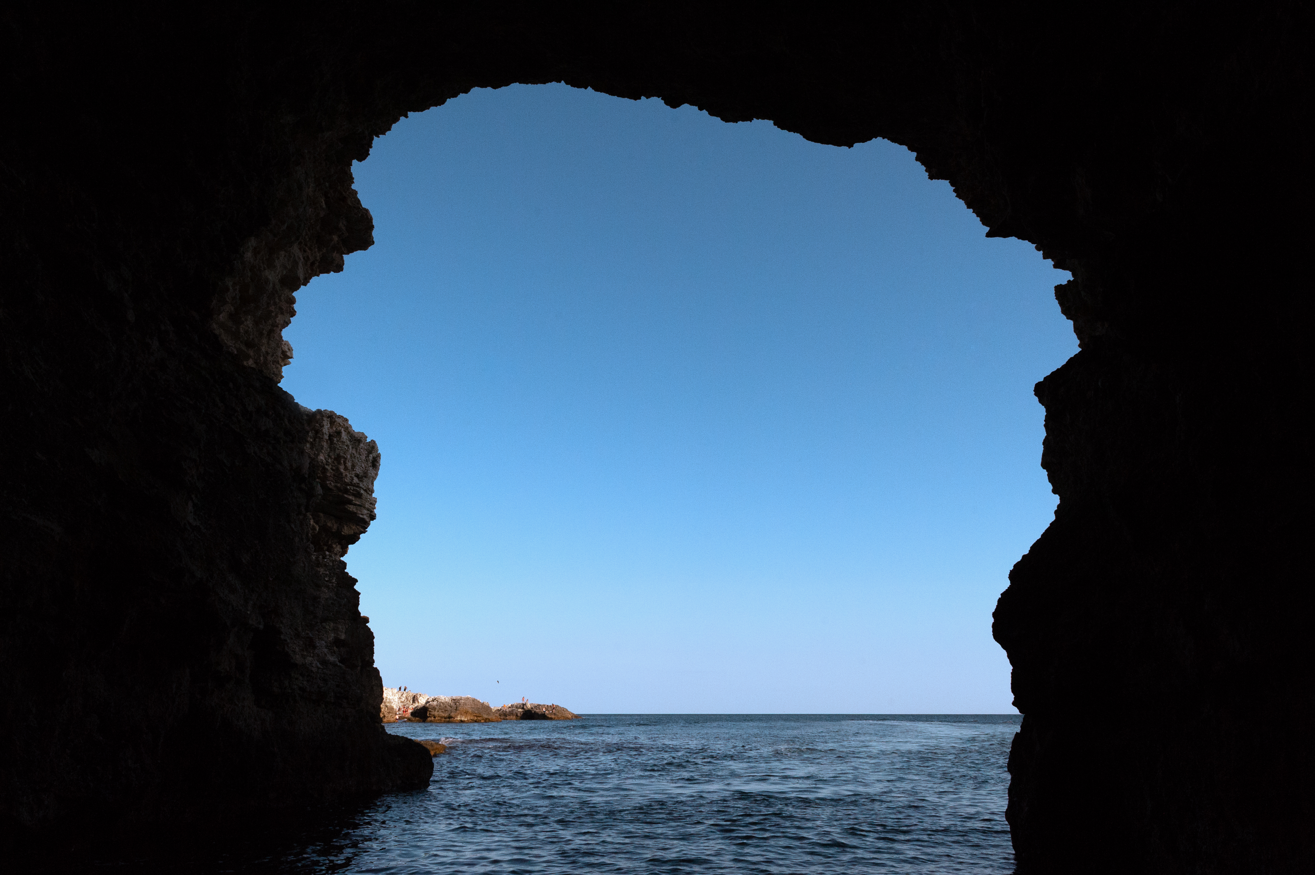
Русский: На фотографии изображена природная арка Атлеша (ландшафтно-рекреационного парка). Снимок был сделан во время прогулки на катере. Немного информации о ландшафтно-рекреационном парке Атлеш: Ландшафтно-рекреационный парк Атле́ш (укр. Ландшафтно-рекреаційний парк Атлеш, крымскотат. Atleş landşaft-raatlıq parkı, Атлеш ландшафт-раатлыкъ паркы) — ландшафтно-рекреационный парк, расположенный на Тарханкутском полуострове на территории Черноморского района. Площадь — 260 га. Землепользователь — Министерство экологии и природных ресурсов Республики Крым, государственное бюджетное учреждение Республики Крым национальный природный парк «Тарханкутский».Парк создан с целью сохранения в природном состоянии типичных и уникальных природных и историко-культурных комплексов и объектов, а также обеспечения условий для эффективного развития туризма, организованного отдыха и рекреационной инфраструктуры в природных условиях с соблюдением режима охраны заповедных природных комплексов и объектов, содействия экологическому образованию и воспитанию населения.
Расположен в южной части западной оконечности Тарханкутского полуострова в границах природного парка Тарханкутский (Прекрасная гавань) на территории Оленевского сельсовета Черноморского района, за границами населённых пунктов. Занимает участок абразивной береговой линии Чёрного моря от мыса Большой Атлеш (не включая его) до бухты Пристань (Гнилая), что южнее села Оленевка. Территория включает мыс Малый Атлеш и бухта с подводным туннелем Чаша любви. Границы парка повторяют береговую линию, где ширина суши в восточной части достигает 300-350 м от берега, акватории — 300 м. Суша парка составляет 80 га, акватория — 180 га. Западнее расположено урочище Большой Атлеш. Парк имеет функциональное зонирование: заповедная (22 га), регулируемой рекреации (218 га — 49 га суши и 169 га акватории), стационарной рекреации (5 га), хозяйственная (15 га — 4 га суши и 11 га акватории) зоны. Заповедная зона представлена участком степи северо-западнее бухты Пристань. Ближайший населённый пункт — село Оленевка, расположенное севернее, город — Евпатория.English: The photo shows the natural arch of Atlesh (landscape and recreational park). The picture was taken during a boat trip. A little information about the Atlesh Landscape and Recreational Park: Atlesh Landscape and Recreational Park (Ukrainian: Atlesh Landscape and Recreational Park, Krymskotat. Atlesh landşaft-raatlıq parkı, Atlesh landscape-raatlık parks) is a landscape and recreational park located on the Tarkhankut peninsula in the territory of the Black Sea region. The area is 260 hectares . The land user is the Ministry of Ecology and Natural Resources of the Republic of Crimea, the state budgetary institution of the Republic of Crimea National Natural Park "Tarkhankutsky".The park was created with the aim of preserving typical and unique natural and historical-cultural complexes and objects in their natural state, as well as providing conditions for the effective development of tourism, organized recreation and recreational infrastructure in natural conditions in compliance with the regime of protection of protected natural complexes and objects, promoting environmental education and upbringing of the population.
It is located in the southern part of the western tip of the Tarkhankut peninsula within the boundaries of the Tarkhankutsky Nature Park (Beautiful Harbor) on the territory of the Olenevsky Village Council of the Black Sea district, beyond the borders of settlements. It occupies a section of the abrasive coastline of the Black Sea from Cape Bolshoy Atlesh (not including it) to the Marina Bay (Rotten), which is south of the village of Olenevka. The territory includes Cape Maly Atlesh and a bay with an underwater tunnel, the Cup of Love. The boundaries of the park repeat the coastline, where the width of the land in the eastern part reaches 300-350 m from the shore, the water area — 300 m. The land area of the park is 80 hectares, the water area is 180 hectares. To the west is the tract of Bolshoy Atlesh. The park has functional zoning: reserved (22 ha), regulated recreation (218 ha — 49 ha of land and 169 ha of water area), stationary recreation (5 ha), economic (15 ha — 4 ha of land and 11 ha of water area) zones. The protected area is represented by a section of steppe northwest of the Marina Bay. The nearest settlement is the village of Olenevka, located to the north, the city is Yevpatoria. |
| Date | |
| Source | Own work |
| Author | Варенников Денис |
Licensing edit
- You are free:
- to share – to copy, distribute and transmit the work
- to remix – to adapt the work
- Under the following conditions:
- attribution – You must give appropriate credit, provide a link to the license, and indicate if changes were made. You may do so in any reasonable manner, but not in any way that suggests the licensor endorses you or your use.
This image was uploaded as part of Russian Science Photo Competition 2022.
|
File history
Click on a date/time to view the file as it appeared at that time.
| Date/Time | Thumbnail | Dimensions | User | Comment | |
|---|---|---|---|---|---|
| current | 15:36, 31 May 2022 | | 4,256 × 2,832 (7.71 MB) | Варенников Денис (talk | contribs) | Uploaded own work with UploadWizard |
You cannot overwrite this file.
File usage on Commons
There are no pages that use this file.