File:Спалювання плавнів Дніпра.jpg

Size of this preview: 800 × 557 pixels. Other resolutions: 320 × 223 pixels | 640 × 446 pixels | 1,024 × 713 pixels | 1,280 × 892 pixels | 2,560 × 1,783 pixels | 4,503 × 3,137 pixels.
Original file (4,503 × 3,137 pixels, file size: 4.08 MB, MIME type: image/jpeg)
Captions
Captions
On satellite images shows a fire in the Dnipro delta (10.04.2018)
Summary edit
| Description |
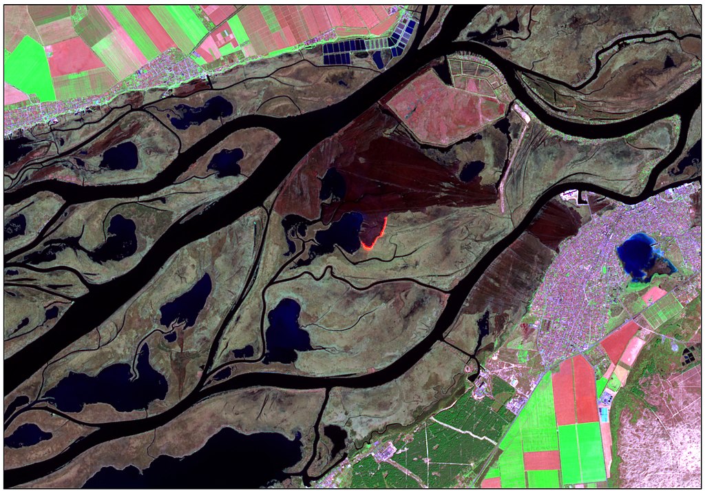
Українська: Відображено спалювання очеретяних плавнів на території заповідної зони дельти Дніпра (Національного природного парка "Нижньодніпровський"). Зображення отримане 10 квітня 2018 року супутником Sentinel-2. Цей космічний знімок завантажений з відкритого ресурсу Copernicus Open Access Hub у вигляді даних відображення земної поверхні у різних спектральних діапазонах, тому я використала набір методів обробки дистанційних даних (таких як комбінація каналів, мозаїка та покращення гістограми) щоб отримати це зображення. Знімок синтезований у «штучних кольорах», де кольорам зображення поставлені у відповідність наступні спектральні канали супутникового зображення із різних частин електромагнітного спектру: 1 – SWIR Band (2190 нм), 2 - NIR Band (842 нм), 3 – Green (560 нм).
Сухі непошкоджені очеретяні плавні на знімку мають світло коричневий з зеленим колір, а вигорілі ділянки мають більш темний колір, подібний до темно коричневого. В центрі знімку ми бачимо осередок загорання з яскравими язиками полум'я, площа вигорілої ділянки на момент зйомки склала близько 8 км2 та поширювалася далі ще на 4 км2. Раніше, на думку науковців, зимові спалювання плавнів сприяли розвитку екосистеми, але такі пожежі категорично не можна робити весною, коли птахи вже сидять на гніздах та ще й на заповідній території.
English: Displaying burning of reed beds in the territory of the Dnipro Delta protected area (Lower Dnipro National Nature Park). The satellite image was received on April 10, 2018 by the Sentinel-2. This satellite image was downloaded from source Copernicus Open Access Hub, which was itself a surface reflection data in different spectral bands, so I applied a set of processing techniques (such as image mosaic and subset, band combinations and fusion, radiometric and histogram enhancement, etc) to get that image. The сomposite is created in "artificial colors" where the following channels of the satellite image from different parts of the electromagnetic spectrum are matched to the image colors: 1 - SWIR Band (2190 нм), 2 - NIR Band (842 nm), 3 - Green Band (560 nm).
The dry, undamaged reed bed on the satellite image is light brown with green, and the burned out areas have a darker color similar to dark brown. In the center of the satellite image, we see a fire focus with bright tongues of flame, the area of the burned out area at the time of the of space shooting was about 8 km2 and extended further by 4 km2. Earlier, according to scientists, winter burning of reed bed contributed to the development of the ecosystem, but such fires can definitely not be done in the spring when the birds are already sitting on nests and especially in the protected area. English: Displaying burning of reed beds in the territory of the Dnipro Delta protected area (Lower Dnipro National Nature Park). The satellite image was received on April 10, 2018 by the Sentinel-2. |
| Date | |
| Source | Own work |
| Author | Tomchenko Olha |
| Camera location | | View this and other nearby images on: OpenStreetMap |
|---|
Licensing edit
I, the copyright holder of this work, hereby publish it under the following license:
This file is licensed under the Creative Commons Attribution 4.0 International license.
- You are free:
- to share – to copy, distribute and transmit the work
- to remix – to adapt the work
- Under the following conditions:
- attribution – You must give appropriate credit, provide a link to the license, and indicate if changes were made. You may do so in any reasonable manner, but not in any way that suggests the licensor endorses you or your use.
| This image was uploaded as part of Wiki Science Competition 2019. |
File history
Click on a date/time to view the file as it appeared at that time.
| Date/Time | Thumbnail | Dimensions | User | Comment | |
|---|---|---|---|---|---|
| current | 21:17, 25 November 2019 | | 4,503 × 3,137 (4.08 MB) | Tomch olha (talk | contribs) | User created page with UploadWizard |
You cannot overwrite this file.
File usage on Commons
The following page uses this file:
File usage on other wikis
The following other wikis use this file:
- Usage on es.wikipedia.org
- Usage on ua.wikimedia.org
- Usage on uk.wikipedia.org