File:ארץ ישראל והארצות שסביבותיה (FL6883087 2370174).jpg
Size of this preview: 800 × 298 pixels. Other resolutions: 320 × 119 pixels | 640 × 238 pixels | 1,024 × 381 pixels | 1,280 × 477 pixels | 4,596 × 1,712 pixels.
Original file (4,596 × 1,712 pixels, file size: 11.31 MB, MIME type: image/jpeg)
Captions
Captions
Add a one-line explanation of what this file represents
Summary
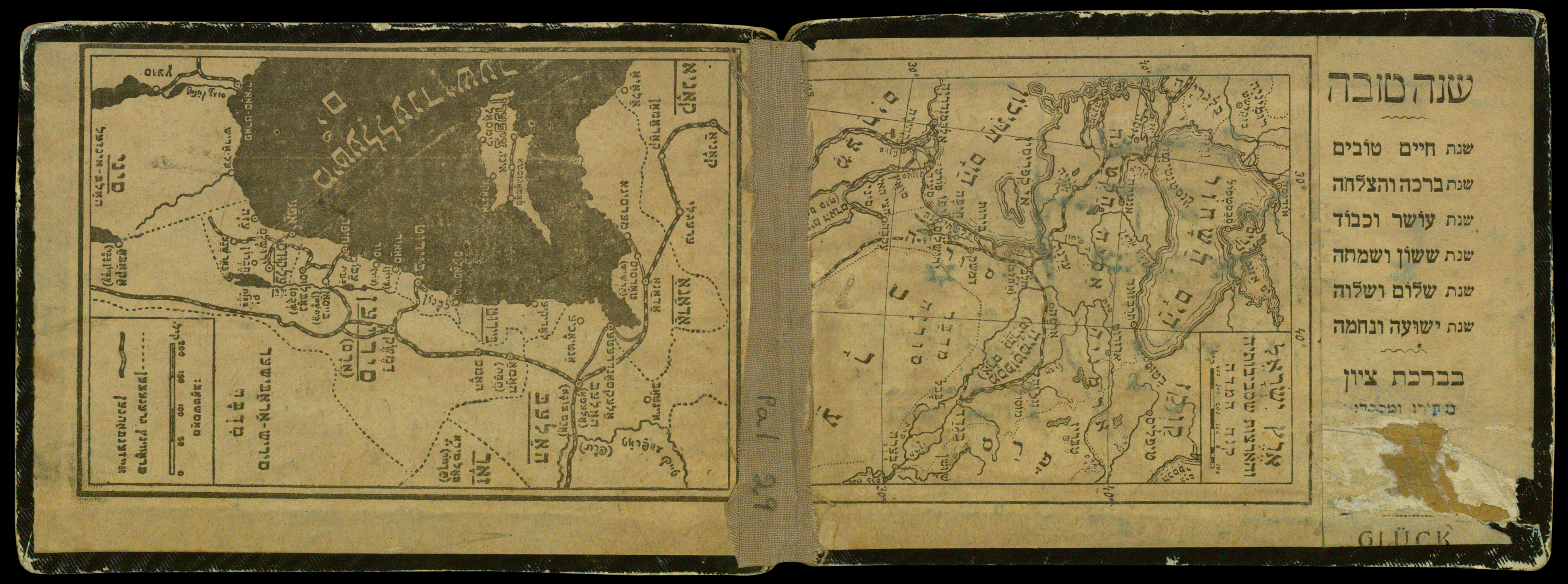
edit| ארץ ישראל והארצות שסביבותיה
( |
||||||||||||||||||||||||
|---|---|---|---|---|---|---|---|---|---|---|---|---|---|---|---|---|---|---|---|---|---|---|---|---|
| Title |
ארץ ישראל והארצות שסביבותיה |
|||||||||||||||||||||||
| Description |
ארץ ישראל והארצות שסביבותיה. |
|||||||||||||||||||||||
| Language | Yiddish, Hebrew | |||||||||||||||||||||||
| Publication date | 1915 | |||||||||||||||||||||||
| Dimensions | 125 × 85 mm (4.92 × 3.34 in) | |||||||||||||||||||||||
| Collection |
|
|||||||||||||||||||||||
| Current location |
|
|||||||||||||||||||||||
| Place of publication | Jerusalem | |||||||||||||||||||||||
| search Merhav catalog | Jerusalem | |||||||||||||||||||||||
| Notes | המפה על פנים המעטפת הקדמית. מפה נוספת [ארץ ישראל ושכנותיה] על פנים המעטפת האחורית, ביידיש, ללא כותרת.; כותר מעטפת בעותק 1: מפת ארץ ישראל ומושבותיה - אדמת קודש; כותר מעטפת בעותק 2: מפת ארץ ישראל ומושבותיה - לשנה טובה; בעותק 1, מצורף דף מקופל שכותרתו מפת ארץ ישראל והמושבות, ובו מפית ירושלים וסביב לה, jer h74, רשימת מושבות עבריות בארץ ישראל, ובעמוד האחרון טקסט טבע הארץ ותוצאותיה המכיל פירוט לפי חודשים של מזג האוויר והתוצרים החקלאיים, וכן רשימה מושלי הארץ ושלטוניה. פירוט טבע הארץ ומושלי הארץ הינו גרסא מעודכנת לטקסט המופיע במפת אפריים גרוור, אודסה 1899, pal 651.; התאריך לקוח מן הטקסט של הדף המצורף לעותק 2. | |||||||||||||||||||||||
| IE PID | IE6883085 | |||||||||||||||||||||||
| Rosetta filename | FL6883087 | |||||||||||||||||||||||
| NNL item ID (P3959) | 990023701740205171 | |||||||||||||||||||||||
| search Merhav catalog | Yiddish, Hebrew | |||||||||||||||||||||||
| search Merhav catalog | מפת ארץ ישראל ומושבותיה | |||||||||||||||||||||||
| Source/Photographer |
|
|||||||||||||||||||||||
| Other versions | ||||||||||||||||||||||||
| Jpg / Tif version |
|
|||||||||||||||||||||||


.jpg&action=edit§ion=1)
Licensing
edit.jpg&action=edit§ion=2)
This work was published before January 1, 1916 and it is anonymous or pseudonymous due to unknown authorship. It is in the public domain in the United States as well as countries and areas where the copyright terms of anonymous or pseudonymous works are 108 years or fewer since publication.
|
File history
Click on a date/time to view the file as it appeared at that time.
| Date/Time | Thumbnail | Dimensions | User | Comment | |
|---|---|---|---|---|---|
| current | 23:31, 4 August 2023 | 4,596 × 1,712 (11.31 MB) | Geagea (talk | contribs) | pattypan 22.03 |
You cannot overwrite this file.
File usage on Commons
The following 2 pages use this file:
.jpg)
.jpg&oldid=790293013)