File:خريطة الرياض.png

Size of this preview: 800 × 457 pixels. Other resolutions: 320 × 183 pixels | 640 × 366 pixels | 1,278 × 730 pixels.
Original file (1,278 × 730 pixels, file size: 2.62 MB, MIME type: image/png)
Captions
Captions
Add a one-line explanation of what this file represents
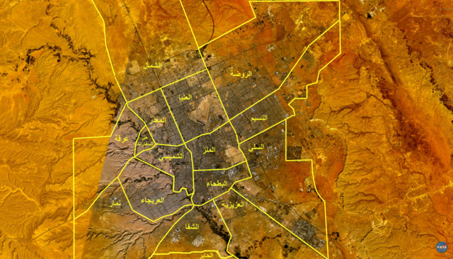
{{Speedy Delete|I uploaded a better version called خريطة_الرياض.JPG صورة فضائية لمدينة الرياض موضحة عليها البلديات الفرعية الخمس عشرة. The 15 municipal districts of the city of Riyadh, Saudi Arabia.
| This image is in the public domain because it is a screenshot from NASA’s globe software World Wind using a public domain layer, such as Blue Marble, MODIS, Landsat, SRTM, USGS or GLOBE.
|
 |
File history
Click on a date/time to view the file as it appeared at that time.
| Date/Time | Thumbnail | Dimensions | User | Comment | |
|---|---|---|---|---|---|
| current | 22:46, 6 June 2007 | | 1,278 × 730 (2.62 MB) | Slackerlawstudent~commonswiki (talk | contribs) | صورة فضائية لمدينة الرياض موضحة عليها البلديات الفرعية الخمس عشرة. The 15 municipal districts of the city of Riyadh, Saudi Arabia. {{PD-WorldWind}} Category:Maps of Saudi Arabia [[Category:Sate |
You cannot overwrite this file.
File usage on Commons
The following page uses this file: