File:خريطة دولة الادارسة.png

Size of this preview: 800 × 548 pixels. Other resolutions: 320 × 219 pixels | 640 × 438 pixels | 1,013 × 694 pixels.
Original file (1,013 × 694 pixels, file size: 55 KB, MIME type: image/png)
Captions
Captions
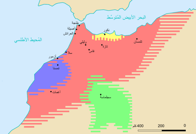
Idrissid Dynasty whos ruled morocco and some parts from Algeria
Summary
edit
| Description |
English: خارطة للمغرب خلال العهد الإدريسي، تستندُ في المقام الأوَّل على:
- خرائط موقع يورأطلس [1][2] - وأعمال پيتر شيپرد [3]. - ووصف تقسيم المملكة المغربيَّة بين ورثة إدريس الثاني سنة 828م [4][5][6]. |
| Date | |
| Source | https://commons.m.wikimedia.org/wiki/File:Mapa_pol%C3%ADtico_de_Marrocos_(s%C3%A9c._VIII-XI)-ar.png#mw-jump-to-license |
| Author | Omar-toon |
-ar.png#mw-jump-to-license)
Licensing
edit
This file is licensed under the Creative Commons Attribution-Share Alike 4.0 International license.
- You are free:
- to share – to copy, distribute and transmit the work
- to remix – to adapt the work
- Under the following conditions:
- attribution – You must give appropriate credit, provide a link to the license, and indicate if changes were made. You may do so in any reasonable manner, but not in any way that suggests the licensor endorses you or your use.
- share alike – If you remix, transform, or build upon the material, you must distribute your contributions under the same or compatible license as the original.
File history
Click on a date/time to view the file as it appeared at that time.
| Date/Time | Thumbnail | Dimensions | User | Comment | |
|---|---|---|---|---|---|
| current | 22:52, 1 April 2022 | | 1,013 × 694 (55 KB) | Zakaria El Sanhadji (talk | contribs) | Uploaded a work by Omar-toon from https://commons.m.wikimedia.org/wiki/File:Mapa_pol%C3%ADtico_de_Marrocos_(s%C3%A9c._VIII-XI)-ar.png#mw-jump-to-license with UploadWizard |
You cannot overwrite this file.
File usage on Commons
There are no pages that use this file.
File usage on other wikis
The following other wikis use this file:
- Usage on ar.wikipedia.org
- Usage on ary.wikipedia.org