File:نقشه توپوگرافی و عمق سنجی استان بوشهر.png

Size of this preview: 400 × 600 pixels. Other resolutions: 160 × 240 pixels | 320 × 480 pixels | 512 × 768 pixels | 683 × 1,024 pixels | 1,366 × 2,048 pixels | 7,200 × 10,794 pixels.
Original file (7,200 × 10,794 pixels, file size: 22.65 MB, MIME type: image/png)
Captions
Captions
Add a one-line explanation of what this file represents
Summary
edit| Description |
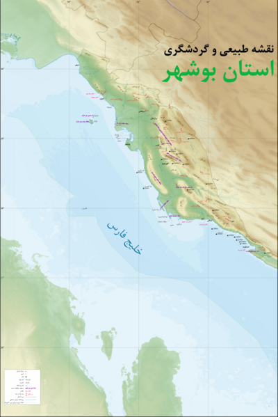
فارسی: نقشه توپوگرافی و عمق سنجی استان بوشهر که در آن مرز دریایی بین المللی هم رسم شده است. در این نقشه نام کوه ها از نقشه های بریتانیایی و امریکایی موجود در کتابخانه دانشگاه تگزاس در آستین یافته شده است که از قدیم بر روی این کوه ها قرار داده بودند. محل تالاب ها و سدها نیز با استفاده از نقشه های آنلاین مانند گوگل مپ یافته شده است. |
| Date | |
| Source | Own work |
| Author | Rohalamin |
| Other versions |
|

Licensing
edit
|
I, the copyright holder of this work, hereby publish it under the following license:
This file is licensed under the Creative Commons Attribution-Share Alike 4.0 International license.
- You are free:
- to share – to copy, distribute and transmit the work
- to remix – to adapt the work
- Under the following conditions:
- attribution – You must give appropriate credit, provide a link to the license, and indicate if changes were made. You may do so in any reasonable manner, but not in any way that suggests the licensor endorses you or your use.
- share alike – If you remix, transform, or build upon the material, you must distribute your contributions under the same or compatible license as the original.
File history
Click on a date/time to view the file as it appeared at that time.
| Date/Time | Thumbnail | Dimensions | User | Comment | |
|---|---|---|---|---|---|
| current | 10:27, 12 August 2023 | | 7,200 × 10,794 (22.65 MB) | Rohalamin (talk | contribs) | some more data is added |
| 06:05, 10 August 2023 |  | 7,200 × 10,794 (22.48 MB) | Rohalamin (talk | contribs) | some details added | |
| 06:50, 4 August 2023 |  | 7,200 × 10,794 (22.47 MB) | Rohalamin (talk | contribs) | some details added | |
| 00:46, 27 June 2023 |  | 7,200 × 10,794 (22.41 MB) | Rohalamin (talk | contribs) | some more data is added | |
| 13:51, 23 April 2022 |  | 7,200 × 10,794 (22.22 MB) | Rohalamin (talk | contribs) | lines added | |
| 13:46, 23 April 2022 |  | 7,200 × 10,794 (22.33 MB) | Rohalamin (talk | contribs) | om-sile island drawed | |
| 07:10, 23 April 2022 |  | 7,200 × 10,794 (22.2 MB) | Rohalamin (talk | contribs) | Uploaded own work with UploadWizard |
You cannot overwrite this file.
File usage on Commons
The following page uses this file:
File usage on other wikis
The following other wikis use this file:
- Usage on fa.wikipedia.org
- استان بوشهر
- رود مند
- منطقه حفاظتشده مند
- رود شاپور
- پارک ملی نایبند
- منطقه حفاظتشده حله
- رود حله
- رود دالکی
- ویکیپدیا:نگارههای برگزیده/نقشه
- پناهگاه حیات وحش خارگ
- پارک ملی دریایی نخیلو
- ویکیپدیا:گزیدن نگاره برگزیده/مه-۲۰۲۲
- ویکیپدیا:گزیدن نگاره برگزیده/نقشه توپوگرافی و عمق سنجی استان بوشهر.png
- ویکیپدیا:نگاره روز/ژانویه ۲۰۲۴
- الگو:نر/2024-01-07
- الگو:نر محافظت شده/2024-01-07
- تالاب حله