File:სოფელი დოჭუ.jpg

Size of this preview: 800 × 600 pixels. Other resolutions: 320 × 240 pixels | 640 × 480 pixels | 1,024 × 768 pixels | 1,280 × 960 pixels | 2,560 × 1,920 pixels | 5,152 × 3,864 pixels.
Original file (5,152 × 3,864 pixels, file size: 5.66 MB, MIME type: image/jpeg)
Captions
Captions
Add a one-line explanation of what this file represents
Summary edit
| Description |
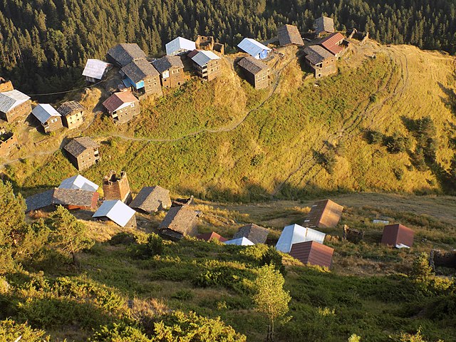
English: Village Dochu is located on the southern slope of the Tusheti Alzani and Pirikti Alazani watershed. 2050 meters above sea level, 102 km from Akhmeta. ქართული: სოფელი დოჭუ, მდებარეობს თუშეთის ალზანისა და პირიქითი ალაზნის წყალგამყოფ მაკრატელას ქედის სამხრეთ კალთაზე. ზღვის დონიდან 2050 მეტრი, ახმეტიდან 102 კილომეტრი.
|
||
| Date | |||
| Source | Own work | ||
| Author | Lasha ge |
Assessment edit

|
This image was awarded with the 9th prize in the national contest of Georgia in Wiki Loves Monuments 2018 Other languages:
|

|
This image was uploaded as part of Wiki Loves Monuments 2018.
|
 |
Licensing edit
I, the copyright holder of this work, hereby publish it under the following license:
This file is licensed under the Creative Commons Attribution-Share Alike 4.0 International license.
- You are free:
- to share – to copy, distribute and transmit the work
- to remix – to adapt the work
- Under the following conditions:
- attribution – You must give appropriate credit, provide a link to the license, and indicate if changes were made. You may do so in any reasonable manner, but not in any way that suggests the licensor endorses you or your use.
- share alike – If you remix, transform, or build upon the material, you must distribute your contributions under the same or compatible license as the original.
File history
Click on a date/time to view the file as it appeared at that time.
| Date/Time | Thumbnail | Dimensions | User | Comment | |
|---|---|---|---|---|---|
| current | 20:33, 12 September 2018 | | 5,152 × 3,864 (5.66 MB) | Lasha ge (talk | contribs) | User created page with UploadWizard |
You cannot overwrite this file.
File usage on Commons
The following 2 pages use this file:
File usage on other wikis
The following other wikis use this file:
- Usage on ce.wikipedia.org
- Usage on hy.wikipedia.org
- Usage on ka.wikipedia.org
- Usage on ru.wikipedia.org
- Usage on uk.wikipedia.org
- Usage on www.wikidata.org