File:多摩川の衛星写真001.jpg

Size of this preview: 800 × 351 pixels. Other resolutions: 320 × 140 pixels | 851 × 373 pixels.
Original file (851 × 373 pixels, file size: 106 KB, MIME type: image/jpeg)
Captions
Captions
Add a one-line explanation of what this file represents
Summary
edit
| Description |
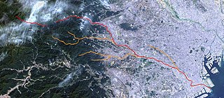
日本語: 多摩川の衛星写真。赤が流路。左の空白部分は奥多摩湖。
橙色は主な支流。左から秋川(上が北秋川、下が南秋川)、浅川(同じく北浅川、南浅川)、野川。 Landsat衛星写真+カシミールによる |
| Source | The Landsat satellite pictures are used for this image. The data came from Global Land Cover Facility (GLCF), and are processed with Kashmir 3D. |
| Author | Global Land Cover Facility (GLCF) |
Licensing
edit
| The Landsat satellite pictures are used for this image. The data came from Global Land Cover Facility (GLCF), and are processed with Kashmir 3D. |
| This file is licensed under the Creative Commons Attribution-Share Alike 3.0 Unported license. Subject to disclaimers. | ||
| ||
| This licensing tag was added to this file as part of the GFDL licensing update. |

|
Permission is granted to copy, distribute and/or modify this document under the terms of the GNU Free Documentation License, Version 1.2 or any later version published by the Free Software Foundation; with no Invariant Sections, no Front-Cover Texts, and no Back-Cover Texts. A copy of the license is included in the section entitled GNU Free Documentation License. Subject to disclaimers. |
File history
Click on a date/time to view the file as it appeared at that time.
| Date/Time | Thumbnail | Dimensions | User | Comment | |
|---|---|---|---|---|---|
| current | 07:34, 12 October 2004 | | 851 × 373 (106 KB) | っ (talk | contribs) | Landsat衛星写真+カシミールによる たぶんPDだと思うのですが |
You cannot overwrite this file.
File usage on Commons
The following page uses this file:
File usage on other wikis
The following other wikis use this file:
- Usage on ja.wikipedia.org
- Usage on www.wikidata.org
- Usage on zh.wikipedia.org