File:昭和30年代の多摩川.jpg

Size of this preview: 800 × 552 pixels. Other resolutions: 320 × 221 pixels | 640 × 441 pixels | 992 × 684 pixels.
Original file (992 × 684 pixels, file size: 512 KB, MIME type: image/jpeg)
Captions
Captions
Add a one-line explanation of what this file represents
Summary edit
| Description |
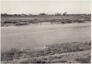
日本語: 撮影時期は昭和30年代、撮影場所は位置情報参照(二子玉川の川辺から川崎側を望む、この付近にボート屋さんがあった)。地元の方によると「昭和20年代には鮎がたくさん泳いでいた多摩川も高度成長期に入って水質が悪くなり、川からはドブのような異臭がし、洗剤の泡が浮かぶ様子で泳げない川になってしまった」とのこと。また、写真からわかるように、当時の多摩川は川幅が広かった。 |
| Date | |
| Source | Own work |
| Author | 二子玉川商店街振興組合 |
| Camera location | | View this and other nearby images on: OpenStreetMap |
|---|
Licensing edit
I, the copyright holder of this work, hereby publish it under the following license:
This file is licensed under the Creative Commons Attribution-Share Alike 4.0 International license.
- You are free:
- to share – to copy, distribute and transmit the work
- to remix – to adapt the work
- Under the following conditions:
- attribution – You must give appropriate credit, provide a link to the license, and indicate if changes were made. You may do so in any reasonable manner, but not in any way that suggests the licensor endorses you or your use.
- share alike – If you remix, transform, or build upon the material, you must distribute your contributions under the same or compatible license as the original.
File history
Click on a date/time to view the file as it appeared at that time.
| Date/Time | Thumbnail | Dimensions | User | Comment | |
|---|---|---|---|---|---|
| current | 08:18, 6 February 2015 | | 992 × 684 (512 KB) | Futako.t (talk | contribs) | User created page with UploadWizard |
You cannot overwrite this file.
File usage on Commons
There are no pages that use this file.