File:河内街道道標.jpg

Size of this preview: 358 × 599 pixels. Other resolutions: 143 × 240 pixels | 286 × 480 pixels | 458 × 768 pixels | 611 × 1,024 pixels | 2,433 × 4,074 pixels.
Original file (2,433 × 4,074 pixels, file size: 2.74 MB, MIME type: image/jpeg)
Captions
Captions
Add a one-line explanation of what this file represents
Summary edit
| Description |
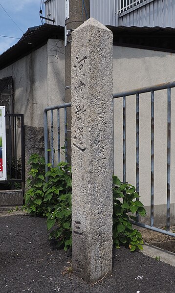
English: Milestone for the Kawachi Kaido in Daito City, Osaka Prefecture, Japan. Installed by the Osaka Prefectural Government in the Meiji era (circa 1897), the stone shows distances to the National Route 2 intersection, Suminodo Station and Shijonawate Station.
日本語: 大阪府大東市深野北に現存する河内街道道標。明治時代に大阪府が設置したもの。正面に「河内街道 枚方町国道第二号の分岐から三里」、裏面に「明治三十年四月改道 大阪府」(年号は読み取りにくいので正確か不明)とある。左右面にそれぞれ住道停車場、四條畷停車場までの距離が記載されている。 |
| Date | |
| Source | Own work |
| Author | Seenen |
| Camera location | | View this and other nearby images on: OpenStreetMap |
|---|
Licensing edit
I, the copyright holder of this work, hereby publish it under the following license:
This file is licensed under the Creative Commons Attribution-Share Alike 4.0 International license.
- You are free:
- to share – to copy, distribute and transmit the work
- to remix – to adapt the work
- Under the following conditions:
- attribution – You must give appropriate credit, provide a link to the license, and indicate if changes were made. You may do so in any reasonable manner, but not in any way that suggests the licensor endorses you or your use.
- share alike – If you remix, transform, or build upon the material, you must distribute your contributions under the same or compatible license as the original.
File history
Click on a date/time to view the file as it appeared at that time.
| Date/Time | Thumbnail | Dimensions | User | Comment | |
|---|---|---|---|---|---|
| current | 01:15, 2 May 2022 | | 2,433 × 4,074 (2.74 MB) | Seenen (talk | contribs) | Uploaded own work with UploadWizard |
You cannot overwrite this file.
File usage on Commons
There are no pages that use this file.
File usage on other wikis
The following other wikis use this file:
- Usage on ja.wikipedia.org