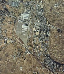
File:貨物輸送現役時の北野桝塚駅航空写真.jpg

Size of this preview: 522 × 599 pixels. Other resolutions: 209 × 240 pixels | 418 × 480 pixels | 669 × 768 pixels | 892 × 1,024 pixels | 2,087 × 2,396 pixels.
Original file (2,087 × 2,396 pixels, file size: 1.36 MB, MIME type: image/jpeg)
Captions
Captions
Add a one-line explanation of what this file represents
Summary
edit| Description | |
| Date | |
| Source | http://w3land.mlit.go.jp/Air/photo400/82/ccb-82-3/c6e/ccb-82-3_c6e_31.jpg |
| Author | 国土交通省 |
| Object location | | View this and other nearby images on: OpenStreetMap |
|---|
Licensing
edit
|
The copyright holder of this file, Ministry of Land, Infrastructure, Transport and Tourism, allows anyone to use it for any purpose, provided that the copyright holder is properly attributed. Redistribution, derivative work, commercial use, and all other use is permitted. |
Attribution:
National Land Image Information (Color Aerial Photographs), created by Ministry of Land, Infrastructure, Transport and Tourism, distributed by Geospatial Information Authority of Japan
|

![[1]](http://w3land.mlit.go.jp/Air/photo400/82/ccb-82-3/c6e/ccb-82-3_c6e_31.jpg)
File history
Click on a date/time to view the file as it appeared at that time.
| Date/Time | Thumbnail | Dimensions | User | Comment | |
|---|---|---|---|---|---|
| current | 13:37, 24 November 2013 | | 2,087 × 2,396 (1.36 MB) | 要塞騎士 (talk | contribs) | User created page with UploadWizard |
You cannot overwrite this file.
File usage on Commons
There are no pages that use this file.
File usage on other wikis
The following other wikis use this file: