File:(Atlas von Liefland, oder von den beyden Gouvernementern u. Herzogthümern Lief- und Ehstland, und der Provinz Oesel - entworfen nach geometrischen Vermessungen, den neusten astronomischen LOC 75572471-5.tif
Size of this JPG preview of this TIF file: 800 × 584 pixels. Other resolutions: 320 × 234 pixels | 640 × 467 pixels | 1,024 × 748 pixels | 1,280 × 935 pixels | 2,560 × 1,870 pixels | 11,368 × 8,302 pixels.
Original file (11,368 × 8,302 pixels, file size: 270.02 MB, MIME type: image/tiff)
Captions
Captions
Add a one-line explanation of what this file represents
Summary edit
| Warning | The original file is very high-resolution. It might not load properly or could cause your browser to freeze when opened at full size. |
|---|
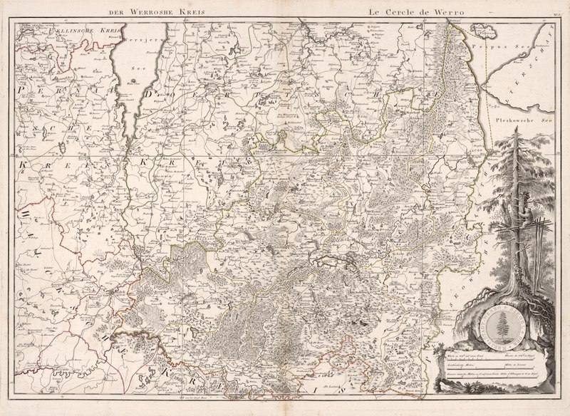
| Description |
English: Relief shown by hachures and pictorially. Sheet titles and legends in German and French. Geographic features in German. Title from title sheet of Copy 2. Maps engraved by Carl Jäck, F. Guimpel, F.G. Franz, and J.N. Champion. Prime meridian: Ferro. Unbound. Similar version described in: Allgemeine geographische ephemeriden. Vol. 34, Jan.-Apr. 1811, p. 80-2. Available also through the Library of Congress Web site as a raster image. Sheets vertically fold-lined at center. Stamped in blue ink in lower left margin of Rigische Kreis sheet: 597A. Sheet for Rigische Kreis mounted on cloth, laminated. LC copy imperfect: Title sheet, explanation sheet, and general map wanting. |
||
| Title | [Atlas von Liefland, oder von den beyden Gouvernementern u. Herzogthümern Lief- und Ehstland, und der Provinz Oesel : entworfen nach geometrischen Vermessungen, den neusten astronomischen Beobachtungen und nach sorgfaeltiger Untersuchung und Kentnis der Gegenden : das Ganze besteht aus einer Generalkarte und vierzehn Kreiskarten = Atlas de la Livonie ou des deux Gouvernemens et Duchés de Livonie et d'Esthonie, avec la Province d'Oesel : composé d'aprés quantité d'arpentages d'aprés la connaissance des lieux mêmes, et les derniérs observations astronomiques : contenant une carte générale et quatorze Cartes Speciales | ||
| Shelf ID | G2122.L5 M4 1798 G2122.L5 M4 1798 Copy 2 Vault : HL 23-17 G2122.L5 M4 1798 Copy 3 Vault : HL 22-5 G2122.L5 M4 1798 Copy 4 | ||
| Parent | https://www.loc.gov/resource/g7022lm.gct00143/ | ||
| Sheet title | No. 5: Der Werrosche Kreis; Le Cercle de Werro | ||
| Date | |||
| Source | https://www.loc.gov/item/75572471/ | ||
| Author | Mellin, Ludvig August; Hartknoch, Johann Friedrich; Jaettnig, Karl; Guimpel, Friedrich; Champion, J. N.; Franz, F. G.; Krause, Johann Wilhelm | ||
| Permission (Reusing this file) |
|
||
| Other versions |
|
||
| Location | Saaremaa Island · Livonia · Estonia | ||
| Part of | American Memory · General Maps · Catalog · Geography And Map Division | ||
| Subject | Estonia · Maps · Early Works To 1800 · Livonia · Saaremaa Island · Saaremaa Island (Estonia) |


Licensing edit
|
This is a faithful photographic reproduction of a two-dimensional, public domain work of art. The work of art itself is in the public domain for the following reason:
The official position taken by the Wikimedia Foundation is that "faithful reproductions of two-dimensional public domain works of art are public domain".
This photographic reproduction is therefore also considered to be in the public domain in the United States. In other jurisdictions, re-use of this content may be restricted; see Reuse of PD-Art photographs for details. | ||||
File history
Click on a date/time to view the file as it appeared at that time.
| Date/Time | Thumbnail | Dimensions | User | Comment | |
|---|---|---|---|---|---|
| current | 05:55, 15 July 2018 |  | 11,368 × 8,302 (270.02 MB) | Fæ (talk | contribs) | LOC Maps multisheet https://www.loc.gov/item/75572471/ sheet 5 of 14 #23454 |
You cannot overwrite this file.
File usage on Commons
The following page uses this file: