File:(Map of Fairfax and Alexandria counties, Virginia, and parts of adjoining counties) LOC 2006627694.jpg

Size of this preview: 761 × 600 pixels. Other resolutions: 305 × 240 pixels | 609 × 480 pixels | 974 × 768 pixels | 1,280 × 1,009 pixels | 2,560 × 2,018 pixels | 10,421 × 8,215 pixels.
Original file (10,421 × 8,215 pixels, file size: 9.17 MB, MIME type: image/jpeg)
Captions
Captions
Add a one-line explanation of what this file represents
Summary edit
| Warning | The original file is very high-resolution. It might not load properly or could cause your browser to freeze when opened at full size. |
|---|
| Description |
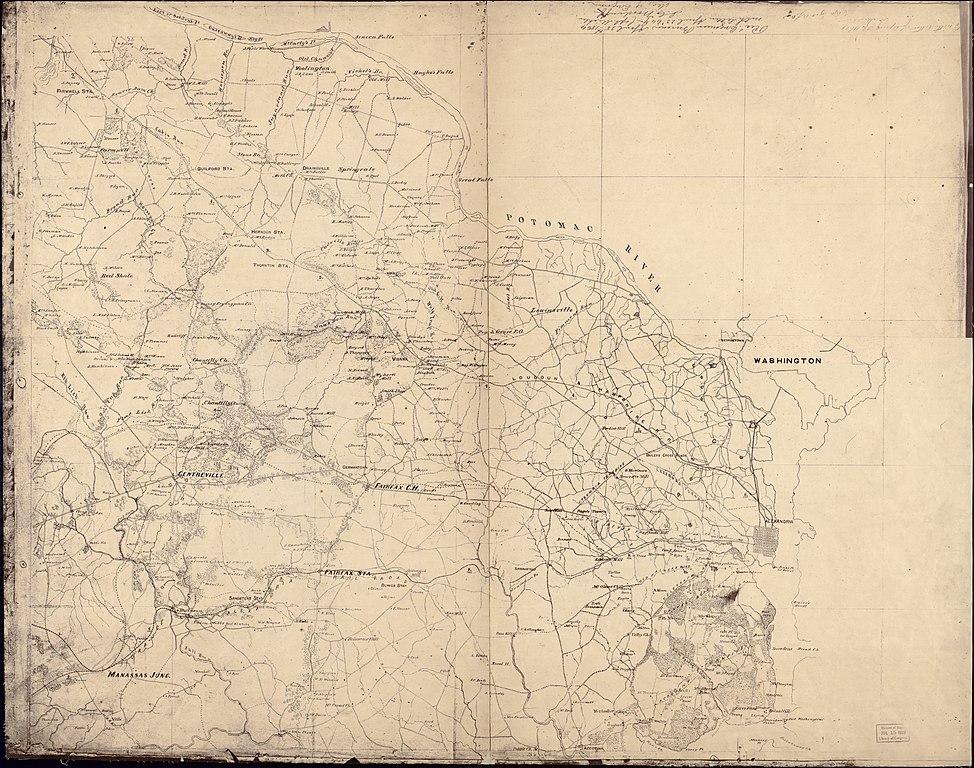
English: Above neat line in right corner: "Recd. Engineer Bureau, April 25th 1864. with letter April 23d '64, fm. Capt. Michler, [signed] J.C. Woodruff, Maj. of Engineers." Map showing the defenses of Washington situated in Virginia, roads, railroads, towns, drainage, vegetation, houses, and names of residents. Description derived from published bibliography. Civil War salted paper maps. AL-6. LC Civil War maps (2nd ed.), 493 Available also through the Library of Congress Web site as a raster image. |
||
| Title | [Map of Fairfax and Alexandria counties, Virginia, and parts of adjoining counties] | ||
| Shelf ID | G3883.F2 1864 .M5 | ||
| Date | |||
| Source | https://www.loc.gov/item/2006627694/ | ||
| Author | Michler, N. (Nathaniel) | ||
| Permission (Reusing this file) |
|
||
| Other versions |
|
||
| Location | United States · Alexandria · Virginia · Fairfax County. · Fairfax County · Alexandria. | ||
| Part of | Military Battles And Campaigns · American Memory · Civil War Maps · Catalog · Geography And Map Division | ||
| Subject | Alexandria · Fairfax County (Va.) · Virginia · Civil War · United States · Maps · Fairfax County · Salted Paper Prints · Alexandria (Va.) · History |


_LOC_2006627694.jpg&action=edit§ion=1)
Licensing edit
_LOC_2006627694.jpg&action=edit§ion=2)
|
This is a faithful photographic reproduction of a two-dimensional, public domain work of art. The work of art itself is in the public domain for the following reason:
The official position taken by the Wikimedia Foundation is that "faithful reproductions of two-dimensional public domain works of art are public domain".
This photographic reproduction is therefore also considered to be in the public domain in the United States. In other jurisdictions, re-use of this content may be restricted; see Reuse of PD-Art photographs for details. | ||||
File history
Click on a date/time to view the file as it appeared at that time.
| Date/Time | Thumbnail | Dimensions | User | Comment | |
|---|---|---|---|---|---|
| current | 12:48, 17 January 2019 | | 10,421 × 8,215 (9.17 MB) | Fæ (talk | contribs) | LOC Maps https://www.loc.gov/item/2006627694/ #13997 |
You cannot overwrite this file.
File usage on Commons
The following page uses this file:
_LOC_2006627694.jpg&oldid=734036726)