File:(Map of parts of Pennsylvania, Maryland, and Virginia covering areas from Harrisburg to Leesburg, and from Hancock to Baltimore). LOC 2005625063.tif

Size of this JPG preview of this TIF file: 800 × 593 pixels. Other resolutions: 320 × 237 pixels | 640 × 475 pixels | 1,024 × 760 pixels | 1,280 × 949 pixels | 2,560 × 1,899 pixels | 13,883 × 10,298 pixels.
Original file (13,883 × 10,298 pixels, file size: 409.03 MB, MIME type: image/tiff)
Captions
Captions
Add a one-line explanation of what this file represents
Summary edit
| Warning | The original file is very high-resolution. It might not load properly or could cause your browser to freeze when opened at full size. |
|---|
| Description |
English: Shows names of some residents. Relief shown by hachures. Title, date, and scale from Stephenson's Civil War maps, 1989. Each sheet pasted together in 3 sections, sectioned in 2, and mounted on cloth. The manuscript original is at the Handley Library in Winchester, Virginia. LC Civil War maps (2nd ed.), H156 In ink in bottom right corner: No. 805. Available also through the Library of Congress web site as raster image. |
||
| Title | [Map of parts of Pennsylvania, Maryland, and Virginia covering areas from Harrisburg to Leesburg, and from Hancock to Baltimore]. | ||
| Shelf ID | G3820 1863 .M3 | ||
| Date | |||
| Source | https://www.loc.gov/item/2005625063/ | ||
| Author | Unknown author | ||
| Permission (Reusing this file) |
|
||
| Other versions |
|
||
| Location | Pennsylvania · United States · Maryland · Virginia | ||
| Part of | Civil War Maps · Hotchkiss Map Collection · Military Battles And Campaigns · Catalog · American Memory · Geography And Map Division | ||
| Subject | Pennsylvania · Virginia · United States · Maps · Maryland · Landowners |

._LOC_2005625063.jpg)
Licensing edit
|
This is a faithful photographic reproduction of a two-dimensional, public domain work of art. The work of art itself is in the public domain for the following reason:
The official position taken by the Wikimedia Foundation is that "faithful reproductions of two-dimensional public domain works of art are public domain".
This photographic reproduction is therefore also considered to be in the public domain in the United States. In other jurisdictions, re-use of this content may be restricted; see Reuse of PD-Art photographs for details. | ||||
File history
Click on a date/time to view the file as it appeared at that time.
| Date/Time | Thumbnail | Dimensions | User | Comment | |
|---|---|---|---|---|---|
| current | 02:38, 2 June 2018 | 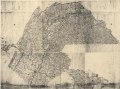 | 13,883 × 10,298 (409.03 MB) | Fæ (talk | contribs) | LOC Maps https://www.loc.gov/item/2005625063/ #17623 |
You cannot overwrite this file.
File usage on Commons
The following page uses this file: