File:-2019-10-18 Information displays, Deep History Point, Mundesley (1).JPG

Size of this preview: 450 × 600 pixels. Other resolutions: 180 × 240 pixels | 360 × 480 pixels | 576 × 768 pixels | 768 × 1,024 pixels | 1,536 × 2,048 pixels | 3,864 × 5,152 pixels.
Original file (3,864 × 5,152 pixels, file size: 7.55 MB, MIME type: image/jpeg)
Captions
Captions
Add a one-line explanation of what this file represents
Summary edit
| Description |
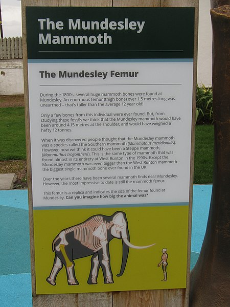
English: An information display board at the Mundesley Deep History Point which is part of the North Norfolk Deep History Coast project. The point is on Beach Road which is located in the village of Overstrand, Norfolk, England. |
|
| Date |
Taken on 18 October 2019 Português: tirada a 18 de Outubro de 2019 |
|
| Source | Own work | |
| Author |
This file is licensed under the Creative Commons Attribution-Share Alike 4.0 International license.
|

.JPG&action=edit§ion=1)
| Object location | | View this and other nearby images on: OpenStreetMap |
|---|
.JPG¶ms=052.877897_N_0001.438312_E_globe:Earth_class:object_type:object__&language=en)

|
The copyright holder of this file, Kolforn (Wikimedia), allows anyone to use it for any purpose, provided that the copyright holder is properly attributed. Redistribution, derivative work, commercial use, and all other use is permitted. |
Attribution:
Kolforn (Wikimedia)
|
File history
Click on a date/time to view the file as it appeared at that time.
| Date/Time | Thumbnail | Dimensions | User | Comment | |
|---|---|---|---|---|---|
| current | 11:35, 18 October 2019 | | 3,864 × 5,152 (7.55 MB) | Kolforn (talk | contribs) | {{Information |Description={{en|An information display board at the Mundesley Deep History Point which is part of the North Norfolk Deep History Coast project. The point is on Pauls lane which is located in the village of {{w|Overstrand}}, Norfolk, England.}} |Source={{own}} |Date={{Taken on|2019-10-18|location=United Kingdom}} {{pt|tirada a 18 de Outubro de 2019}} |Author={{User:Kolforn/Credit}} |Permission= |other_versions= }} {{Object location dec|52.877899, 1.438312}} {{attribution|noli... |
You cannot overwrite this file.
File usage on Commons
There are no pages that use this file.
.JPG&oldid=734520469)