File:0010922 7th century Kharod Indal Deul Mandir Chhattisgarh 021.jpg

Original file (3,468 × 4,624 pixels, file size: 8.78 MB, MIME type: image/jpeg)
Captions
Captions
Summary
edit
| Description |
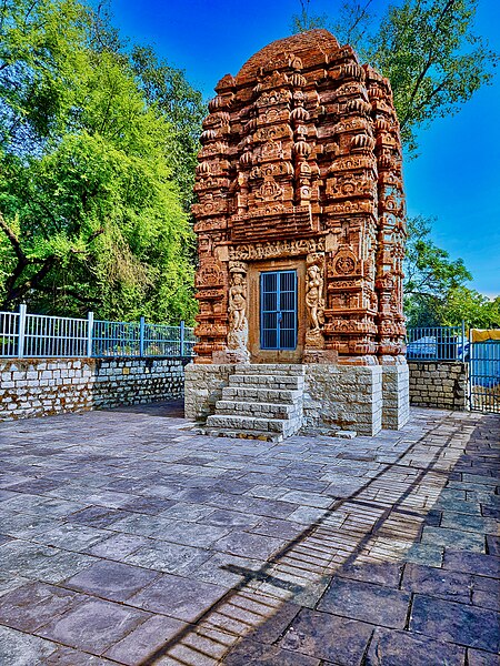
English: This is a brick temple with stellate plan in the ancient town of Kharod. Scholars date it between 650 to 670 CE. It is sometimes referred to as the Andal Deul temple.
Kharod is mentioned as Indrapur and later as Kharod in 6th to 13th century manuscripts, copper plates and inscriptions. Many of these mention gifts of support, construction and repairs of matha (monasteries), vidyashalas (education centers), as well as Hindu and Jain temples. During the medieval era, the number of temples and their pilgrimage significance was so high that Kharod is referred to as the "Kashi of Chhattisgarh". This temple stands on a 4 feet high platform, faces west, and stands on a stone platform. The majority of the temple is made from brick with stucco artwork, while the entrance doorway of the temple are built in stone The temple has a square sanctum plan with sapta-ratha pattern (seven offsets), central bhadra and corner karnas. The overall plan is tarakriti (stellate, star-shaped), but it is a special case of those described in Sanskrit texts on architecture. The artwork has eroded over time, some deliberately damaged likely after the 12th century when the last epigraph mentions a gift to the temple. The notable artwork on the outer walls include Ganesha, Kubera, Durga., Surya, Vishnu riding Garuda, Indra, Gaja-Lakshmi, Shiva, Vishnu Narasimha, Kartikeya,, Shiva-Mahesha trimurti. The sanctum doorway has three sakhas, elegantly carved Ganga and Yamuna, and the lintel display Brahma, Vishnu and Shiva with Parvati on the lalitabimba. Taking all the artwork on the doorway and outer wall, this was built as a Shiva temple that reverentially included all major Hindu traditions. |
| Date | |
| Source | Own work |
| Author | Ms Sarah Welch |
| Camera location | | View this and other nearby images on: OpenStreetMap |
|---|
Licensing
edit
| This file is made available under the Creative Commons CC0 1.0 Universal Public Domain Dedication. | |
| The person who associated a work with this deed has dedicated the work to the public domain by waiving all of their rights to the work worldwide under copyright law, including all related and neighboring rights, to the extent allowed by law. You can copy, modify, distribute and perform the work, even for commercial purposes, all without asking permission.
|
File history
Click on a date/time to view the file as it appeared at that time.
| Date/Time | Thumbnail | Dimensions | User | Comment | |
|---|---|---|---|---|---|
| current | 20:09, 29 November 2022 | | 3,468 × 4,624 (8.78 MB) | Ms Sarah Welch (talk | contribs) | Uploaded own work with UploadWizard |
You cannot overwrite this file.
File usage on Commons
There are no pages that use this file.