File:00 0213 Luzern - Wasserturm und Kapellbrücke.jpg

Size of this preview: 800 × 533 pixels. Other resolutions: 320 × 213 pixels | 640 × 427 pixels | 1,024 × 683 pixels | 1,280 × 853 pixels | 2,560 × 1,707 pixels | 4,500 × 3,000 pixels.
Original file (4,500 × 3,000 pixels, file size: 8.18 MB, MIME type: image/jpeg)
Captions
Captions
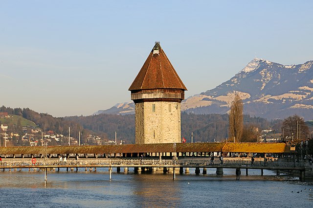
Switzerland: water tower and Chapel Bridge in Lucerne.
Summary edit
| Description |
Deutsch: Der Wasserturm in der Mitte der Kapellbrücke ist ein Teil der historischen Stadtbefestigung von Luzern (CH). Der achteckige Turm ist 34,5 Meter hoch und seine Mauern haben ein Dicke zwischen 3 und 4,5 Metern. Die Kapellbrücke ist mit 203 Meter die zweitlängste überdachte Holzbrücke Europas.
Simple English: The water tower in the middle of the Chapel Bridge is part of the historic city fortification of Lucerne (CH). The octagonal tower is 34.5 meters high and its walls are between 3 and 4.5 meters thick. The Kapellbrücke is at 203 meters the second longest covered wooden bridge in Europe. |
| Date | |
| Source | Own work |
| Author | W. Bulach |
| Camera location | | View this and other nearby images on: OpenStreetMap |
|---|
Licensing edit
I, the copyright holder of this work, hereby publish it under the following license:
This file is licensed under the Creative Commons Attribution-Share Alike 4.0 International license.
- You are free:
- to share – to copy, distribute and transmit the work
- to remix – to adapt the work
- Under the following conditions:
- attribution – You must give appropriate credit, provide a link to the license, and indicate if changes were made. You may do so in any reasonable manner, but not in any way that suggests the licensor endorses you or your use.
- share alike – If you remix, transform, or build upon the material, you must distribute your contributions under the same or compatible license as the original.
File history
Click on a date/time to view the file as it appeared at that time.
| Date/Time | Thumbnail | Dimensions | User | Comment | |
|---|---|---|---|---|---|
| current | 18:22, 19 June 2019 | | 4,500 × 3,000 (8.18 MB) | W. Bulach (talk | contribs) | User created page with UploadWizard |
You cannot overwrite this file.
File usage on Commons
There are no pages that use this file.