File:02F 2018-11-11 2354Z.jpg

Size of this preview: 471 × 599 pixels. Other resolutions: 189 × 240 pixels | 377 × 480 pixels | 604 × 768 pixels | 805 × 1,024 pixels | 1,610 × 2,048 pixels | 6,858 × 8,721 pixels.
Original file (6,858 × 8,721 pixels, file size: 7.01 MB, MIME type: image/jpeg)
Captions
Captions
Add a one-line explanation of what this file represents
Summary
edit
| Description |
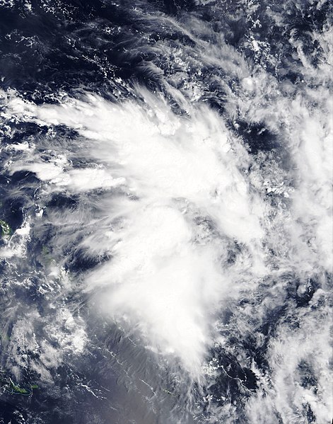
English: Tropical Disturbance 02F located in the far northwestern part of the South Pacific tropical cyclone basin just after being classified by the Fiji Meteorological Service on 11 November 2018. The Solomon Islands are just visible in the lower left-hand portion of the image. |
| Date | |
| Source | NASA Worldview |
| Author | National Aeronautics and Space Administration (NASA) - 'Terra' satellite |
| Camera location | | View this and other nearby images on: OpenStreetMap |
|---|
Licensing
edit
| This file is in the public domain in the United States because it was solely created by NASA. NASA copyright policy states that "NASA material is not protected by copyright unless noted". (See Template:PD-USGov, NASA copyright policy page or JPL Image Use Policy.) | ||
 |
Warnings:
|
File history
Click on a date/time to view the file as it appeared at that time.
| Date/Time | Thumbnail | Dimensions | User | Comment | |
|---|---|---|---|---|---|
| current | 06:40, 12 November 2018 | | 6,858 × 8,721 (7.01 MB) | ChocolateTrain (talk | contribs) | User created page with UploadWizard |
You cannot overwrite this file.
File usage on Commons
There are no pages that use this file.
File usage on other wikis
The following other wikis use this file:
- Usage on en.wikipedia.org
- Usage on pt.wikipedia.org
- Usage on th.wikipedia.org
- Usage on zh.wikipedia.org