File:05W 2015-04-04 0632Z.png

Size of this preview: 600 × 600 pixels. Other resolutions: 240 × 240 pixels | 480 × 480 pixels | 768 × 768 pixels | 1,024 × 1,024 pixels | 1,280 × 1,280 pixels.
Original file (1,280 × 1,280 pixels, file size: 1.15 MB, MIME type: image/png)
Captions
Captions
Add a one-line explanation of what this file represents
Summary
edit
| Description |
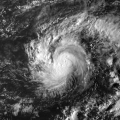
English: Tropical Depression 05W (later being Tropical Storm Haishen) during its peak intensity on April 4, 2015, captured on the MTSAT-2 satellite. |
| Date | |
| Source | https://www.nrlmry.navy.mil/archdat/test/kml/TC/2015/WPAC/05W/visir/20150404.0632.MTSAT2.vis.05W.FIVE.WPAC.png |
| Author | Naval Research Laboratory |
| Metadata | https://www.nrlmry.navy.mil/archdat/test/kml/TC/2015/WPAC/05W/visir/20150404.0632.MTSAT2.vis.05W.FIVE.WPAC.png.txt |
| Satellite | MTSAT-2 |
| Camera location | | View this and other nearby images on: OpenStreetMap |
|---|
Licensing
edit
This file is a work of a sailor or employee of the U.S. Navy, taken or made as part of that person's official duties. As a work of the U.S. federal government, it is in the public domain in the United States.
|
 | |
| This file has been identified as being free of known restrictions under copyright law, including all related and neighboring rights. | ||
File history
Click on a date/time to view the file as it appeared at that time.
| Date/Time | Thumbnail | Dimensions | User | Comment | |
|---|---|---|---|---|---|
| current | 10:16, 2 February 2019 | | 1,280 × 1,280 (1.15 MB) | Nino Marakot (talk | contribs) | User created page with UploadWizard |
You cannot overwrite this file.
File usage on Commons
The following page uses this file:
File usage on other wikis
The following other wikis use this file:
- Usage on en.wikipedia.org