File:06029-Cannes-Hydro-Inon.jpeg

Size of this preview: 739 × 600 pixels. Other resolutions: 296 × 240 pixels | 592 × 480 pixels | 947 × 768 pixels | 1,262 × 1,024 pixels | 2,524 × 2,048 pixels | 4,076 × 3,307 pixels.
Original file (4,076 × 3,307 pixels, file size: 1.81 MB, MIME type: image/jpeg)
Captions
Captions
Add a one-line explanation of what this file represents
Summary
edit
| Description |
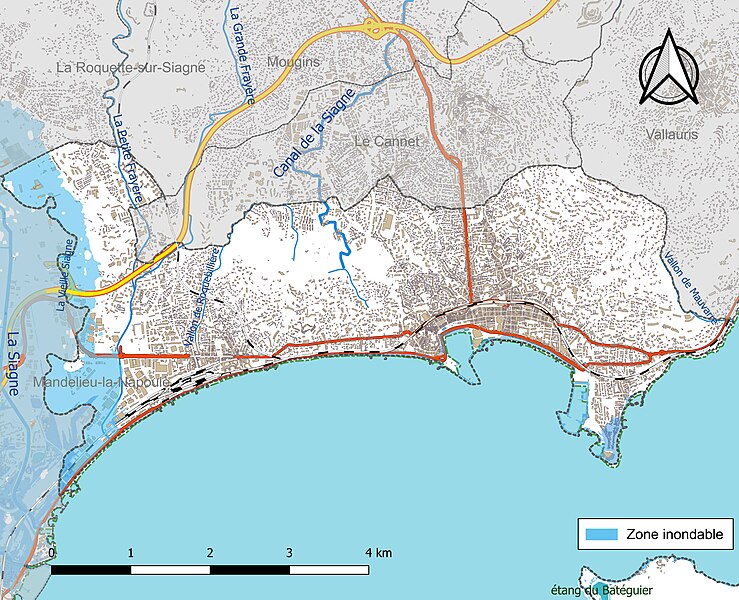
Français : Carte du réseau hydrographique, des infrastructures et de la zone inondable de la commune de fr:Cannes (France). |
| Date | |
| Source |
Own work avec les données : Assemblé et enrichi dans fr:QGis. |
| Author | Roland45 |
Licensing
edit
I, the copyright holder of this work, hereby publish it under the following license:
This file is licensed under the Creative Commons Attribution-Share Alike 4.0 International license.
- You are free:
- to share – to copy, distribute and transmit the work
- to remix – to adapt the work
- Under the following conditions:
- attribution – You must give appropriate credit, provide a link to the license, and indicate if changes were made. You may do so in any reasonable manner, but not in any way that suggests the licensor endorses you or your use.
- share alike – If you remix, transform, or build upon the material, you must distribute your contributions under the same or compatible license as the original.
File history
Click on a date/time to view the file as it appeared at that time.
| Date/Time | Thumbnail | Dimensions | User | Comment | |
|---|---|---|---|---|---|
| current | 14:49, 27 June 2023 | | 4,076 × 3,307 (1.81 MB) | Roland45 (talk | contribs) | {{Information |description = {{fr|1=Carte du réseau hydrographique, des infrastructures et de la zone inondable de la commune de fr:Cannes (France).}} |date = 2023-06-27 |source = {{own}} avec les données : <br>* Découpage administratif communal et départemental : [https://www.data.gouv.fr/fr/datasets/decoupage-administratif-communal-francais-issu-d-openstreetmap/ Export simple de janvier 2021 - vérifié et simplifié à 5 m] sur le site du [https://www.data.gouv.fr/ portail de données l... |
You cannot overwrite this file.
File usage on Commons
There are no pages that use this file.
File usage on other wikis
The following other wikis use this file:
- Usage on fr.wikipedia.org