File:100 Years War France 1435-es.svg

Size of this PNG preview of this SVG file: 601 × 599 pixels. Other resolutions: 241 × 240 pixels | 482 × 480 pixels | 770 × 768 pixels | 1,027 × 1,024 pixels | 2,055 × 2,048 pixels | 948 × 945 pixels.
Original file (SVG file, nominally 948 × 945 pixels, file size: 49 KB)
Captions
Captions
Add a one-line explanation of what this file represents
Summary edit
| Description |
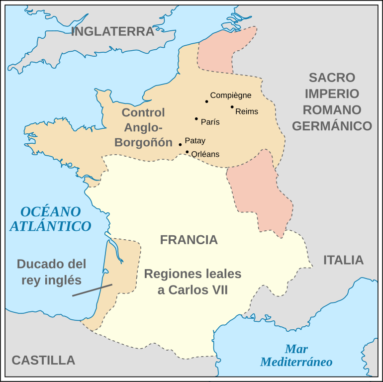
English: France during the 100 Years' War in 1435. *Coastline from a 1991 CIA map. *Relief shading based on GLOBE data. *Country borders from File:Hundred years war france england 1435.jpg. *City locations based on Lat/Long data in their Wikipedia entries, which are further sourced from open projects. (Included in svg point descriptions.)
Español: Francia durante la Guerra de los Cien Años, en 1435. |
| Date | (UTC) |
| Source |
This file was derived from: 100 Years War France 1435.svg:  |
| Author |
|
| Other versions |
[]
|


| This is a retouched picture, which means that it has been digitally altered from its original version. Modifications: translated into Spanish. The original can be viewed here: 100 Years War France 1435.svg:
|
Licensing edit
This file is licensed under the Creative Commons Attribution-Share Alike 3.0 Unported license.
- You are free:
- to share – to copy, distribute and transmit the work
- to remix – to adapt the work
- Under the following conditions:
- attribution – You must give appropriate credit, provide a link to the license, and indicate if changes were made. You may do so in any reasonable manner, but not in any way that suggests the licensor endorses you or your use.
- share alike – If you remix, transform, or build upon the material, you must distribute your contributions under the same or compatible license as the original.
Original upload log edit
This image is a derivative work of the following images:
- File:100_Years_War_France_1435.svg licensed with Cc-by-sa-3.0, GFDL
- 2011-07-11T06:19:49Z Foxyshadis 948x945 (49946 Bytes) Add the locations of other cities related to Joan of Arc, both important battles & sieges and her execution. Domrémy is excluded as unrelated to the war.
- 2010-11-19T07:07:25Z PaulVIF 948x945 (42933 Bytes) {{Translation possible}} [[Category:Maps of the Hundred Years' War]] [[Category:Maps of the history of France]] == {{int:license}} == {{self|cc-by-sa-3.0|GFDL}}
- 2010-11-18T10:52:27Z PaulVIF 948x945 (45139 Bytes) {{Translation possible}} [[Category:Maps of the Hundred Years' War]] [[Category:Maps of the history of France]] == {{int:license}} == {{self|cc-by-sa-3.0|GFDL}}
- 2009-09-03T10:24:40Z Mysid 948x945 (45061 Bytes) remove ugly shading...
- 2009-09-03T10:22:09Z Mysid 948x945 (3208275 Bytes) {{Information |Description={{en|1=France during the 100 Years' War in 1435. *Coastline from a 1991 CIA map. *Relief shading based on GLOBE data. *Country borders from [[:File:Hundred years war france england 1435.jpg]].}} |So
Uploaded with derivativeFX
File history
Click on a date/time to view the file as it appeared at that time.
| Date/Time | Thumbnail | Dimensions | User | Comment | |
|---|---|---|---|---|---|
| current | 10:11, 4 July 2013 | | 948 × 945 (49 KB) | Rowanwindwhistler (talk | contribs) | == {{int:filedesc}} == {{Information |Description={{en|1=France during the 100 Years' War in 1435. *Coastline from a 1991 CIA map. *Relief shading based on GLOBE data. *Country borders from File:Hundred years war france england 1435.jpg. *City loc... |
You cannot overwrite this file.
File usage on Commons
The following 14 pages use this file:
- File:100 Years War France 1435-ar.svg
- File:100 Years War France 1435-es.svg
- File:100 Years War France 1435-fi.svg
- File:100 Years War France 1435-hu.svg
- File:100 Years War France 1435-ru.svg
- File:100 Years War France 1435-sr.svg
- File:100 Years War France 1435-sv.jpg
- File:100 Years War France 1435.svg
- File:100 Years War France 1435 he.svg
- File:100 Years War France 1435 ms.svg
- File:100 Years War France 1435 no-1.svg
- File:Hundred years war france england 1435.jpg
- File:Hundred years war france england 1435 chinese.png
- Template:Other versions/100 Years War France 1435
File usage on other wikis
The following other wikis use this file:
- Usage on en.wikipedia.org
- Usage on es.wikipedia.org