File:14079-LunarNorthPoleMosaic-LRO-20140318.jpg
Original file (2,331 × 1,819 pixels, file size: 935 KB, MIME type: image/jpeg)
Captions
Captions
Summary edit
| Description |
English: March 18, 2014
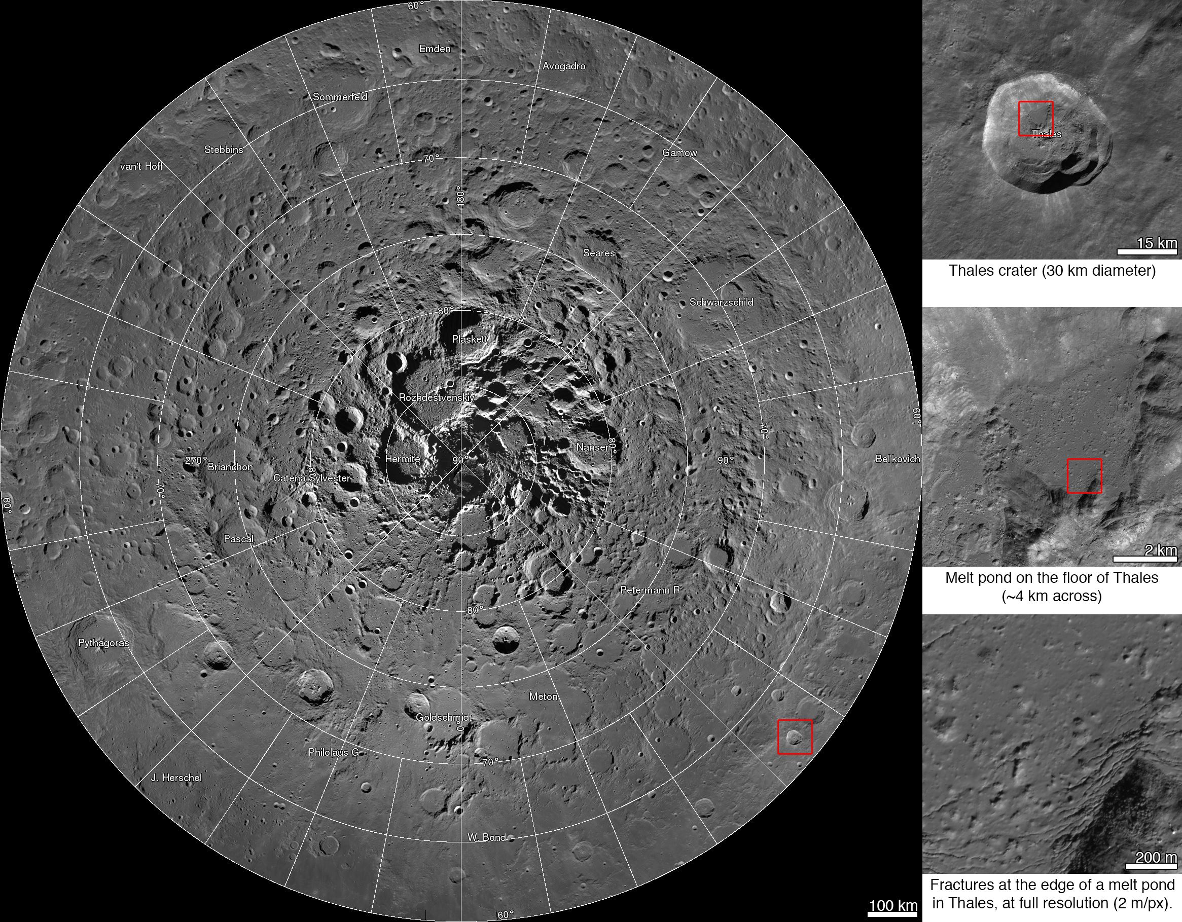
RELEASE 14-079 NASA Releases First Interactive Mosaic of Lunar North Pole http://www.nasa.gov/press/2014/march/nasa-releases-first-interactive-mosaic-of-lunar-north-pole Interactive mosaic from NASA's Lunar Reconnaissance Orbiter A new interactive mosaic from NASA's Lunar Reconnaissance Orbiter covers the north pole of the moon from 60 to 90 degrees north latitude at a resolution of 6-1/2 feet (2 meters) per pixel. Close-ups of Thales crater (right side) zoom in to reveal increasing levels of detail. Scientists, using cameras aboard NASA's Lunar Reconnaissance Orbiter (LRO), have created the largest high resolution mosaic of our moon’s north polar region. The six-and-a-half feet (two-meters)-per-pixel images cover an area equal to more than one-quarter of the United States. Web viewers can zoom in and out, and pan around an area. Constructed from 10,581 pictures, the mosaic provides enough detail to see textures and subtle shading of the lunar terrain. Consistent lighting throughout the images makes it easy to compare different regions. "This unique image is a tremendous resource for scientists and the public alike," said John Keller, LRO project scientist at NASA's Goddard Space Flight Center, Greenbelt, Md. "It's the latest example of the exciting insights and data products LRO has been providing for nearly five years." The images making up the mosaic were taken by the two LRO Narrow Angle Cameras, which are part of the instrument suite known as the Lunar Reconnaissance Orbiter Camera (LROC). The cameras can record a tremendous dynamic range of lit and shadowed areas. "Creation of this giant mosaic took four years and a huge team effort across the LRO project," said Mark Robinson, principal investigator for the LROC at Arizona State University in Tempe. "We now have a nearly uniform map to unravel key science questions and find the best landing spots for future exploration." The entire image measures 931,070 pixels square – nearly 867 billion pixels total. A complete printout at 300 dots per inch – considered crisp resolution for printed publications – would require a square sheet of paper wider than a professional U.S. football field and almost as long. If the complete mosaic were processed as a single file, it would require approximately 3.3 terabytes of storage space. Instead, the processed mosaic was divided into millions of small, compressed files, making it manageable for users to view and navigate around the image using a web browser. LRO entered lunar orbit in June 2009 equipped with seven instrument suites to map the surface, probe the radiation environment, investigate water and key mineral resources, and gather geological clues about the moon's evolution. Researchers used additional information about the moon's topography from LRO's Lunar Orbiter Laser Altimeter, as well as gravity information from NASA's Gravity Recovery and Interior Laboratory (GRAIL) mission, to assemble the mosaic. Launched in September 2011, the GRAIL mission, employing twin spacecraft named Ebb and Flow, generated a gravity field map of the moon -- the highest resolution gravity field map of any celestial body. LRO is managed by Goddard for the Science Mission Directorate (SMD) at NASA Headquarters in Washington. LROC was designed and built by Malin Space Science Systems and is operated by the University of Arizona. NASA's Jet Propulsion Laboratory in Pasadena, Calif., managed the GRAIL mission for SMD.
|
| Date | |
| Source | http://www.nasa.gov/sites/default/files/14-079-lro-mosaic_0.jpg |
| Author | NASA/GSFC/Arizona State University |
Licensing edit
| This file is in the public domain in the United States because it was solely created by NASA. NASA copyright policy states that "NASA material is not protected by copyright unless noted". (See Template:PD-USGov, NASA copyright policy page or JPL Image Use Policy.) | ||
 |
Warnings:
|
File history
Click on a date/time to view the file as it appeared at that time.
| Date/Time | Thumbnail | Dimensions | User | Comment | |
|---|---|---|---|---|---|
| current | 11:52, 19 March 2014 | | 2,331 × 1,819 (935 KB) | Drbogdan (talk | contribs) | User created page with UploadWizard |
You cannot overwrite this file.
File usage on Commons
There are no pages that use this file.