File:1520 Peiraeus.jpg

Size of this preview: 798 × 89 pixels. Other resolutions: 320 × 36 pixels | 4,247 × 474 pixels.
Original file (4,247 × 474 pixels, file size: 257 KB, MIME type: image/jpeg)
Captions
Captions
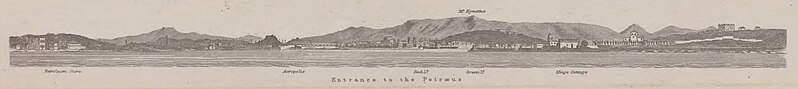
Detail of the entrance to Peiræus Port enclosed in map 1520
Summary
edit
| Description |
English: Detail of the entrance to Peiræus Port enclosed in map 1520 |
| Date | |
| Source | Map 1520 The Peiræus and Phalerum Bay |
| Author | British Admiralty |
| Camera location | | View this and other nearby images on: OpenStreetMap |
|---|
Licensing
edit
This file is licensed under the Creative Commons Attribution-Share Alike 4.0 International license.
- You are free:
- to share – to copy, distribute and transmit the work
- to remix – to adapt the work
- Under the following conditions:
- attribution – You must give appropriate credit, provide a link to the license, and indicate if changes were made. You may do so in any reasonable manner, but not in any way that suggests the licensor endorses you or your use.
- share alike – If you remix, transform, or build upon the material, you must distribute your contributions under the same or compatible license as the original.
File history
Click on a date/time to view the file as it appeared at that time.
| Date/Time | Thumbnail | Dimensions | User | Comment | |
|---|---|---|---|---|---|
| current | 17:06, 21 April 2022 | 4,247 × 474 (257 KB) | Kaimakcalan (talk | contribs) | Uploaded a work by British Admiralty from Map [https://upload.wikimedia.org/wikipedia/commons/6/6c/Admiralty_Chart_No_1520_Greece_The_Peiraeus_and_Phalerum_Bay%2C_Published_1892.jpg The Peiræus and Phalerum Bay] with UploadWizard |
You cannot overwrite this file.
File usage on Commons
There are no pages that use this file.