File:1556 map of Sumatra by Giacomo Gastaldi.jpg

Original file (6,252 × 4,678 pixels, file size: 5.77 MB, MIME type: image/jpeg)
Captions
Captions
Summary edit
| Description |
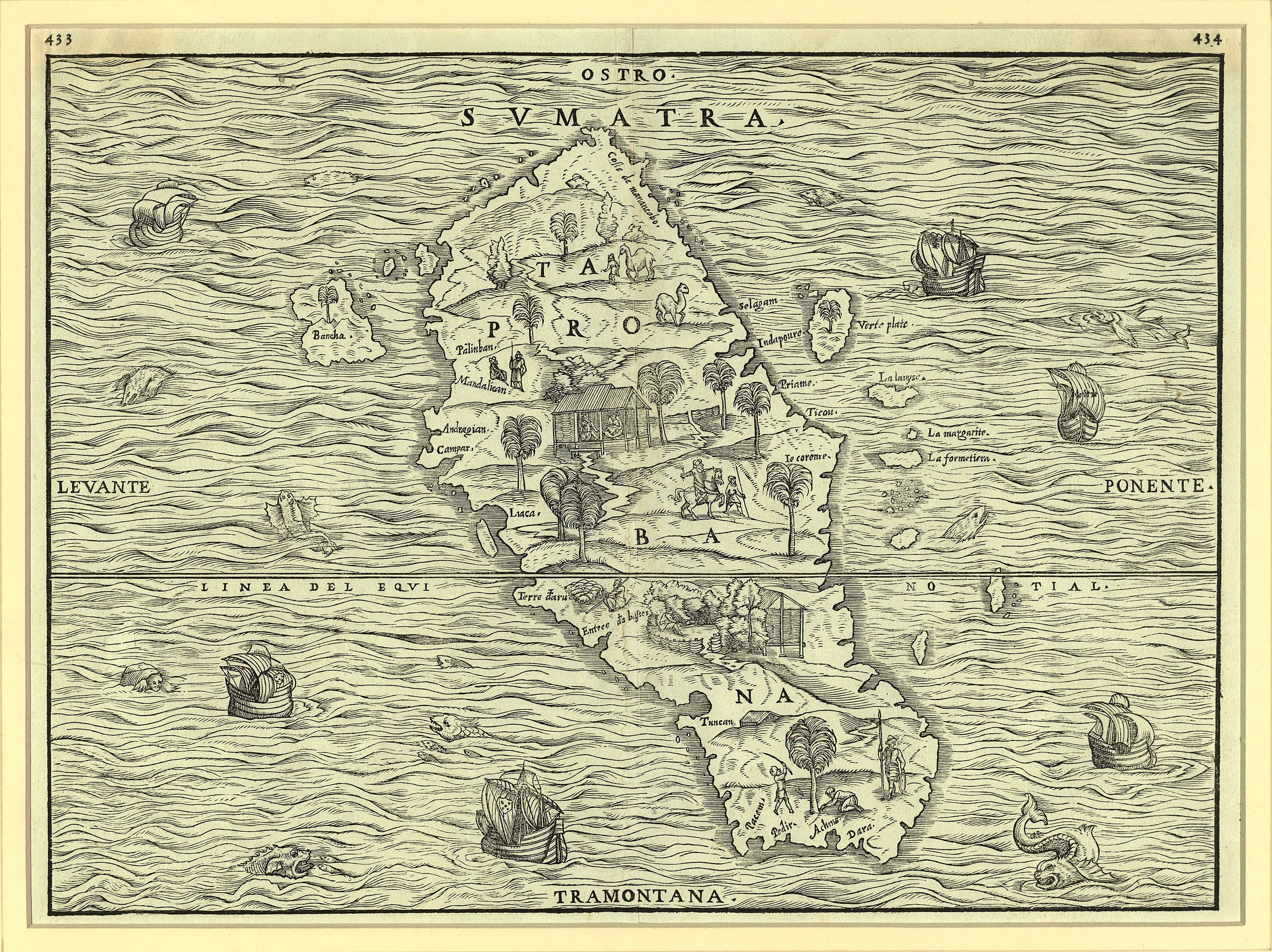
English: This fine woodcut map of Sumatra is the first separate map of an Indonesian island to be based on actual empirical data. It is based on Delle Navigationi et Viaggi (Navigations and travels) by Giovanni Battista Ramusio, which was published in three volumes in Venice in 1550-59. Ramusio was a Venetian diplomat, geographer, and historian.
Delle Navigationi et Viaggi is a massive work that includes Ramusio's translations into Italian of many first-hand accounts of the exploration, up to the mid-16th century, of Africa, the New World, and Asia, along with maps by the Venetian cartographer Giacomo Gastaldi (circa 1500-circa 1565). The book contains an account of the voyage of the Parmentier brothers, Frenchmen who landed on the west coast of Sumatra in 1529 in defiance of the Portuguese monopoly on the spice trade in the East Indies and their blockade on foreign access to the island. Both brothers subsequently died of fever. Prior to the publication of Ramusio's map, Sumatra had been confused with Sri Lanka and maps of the island were largely conjectural, based primarily on the writings of Marco Polo. The map is oriented with south at the top. The shape of the island and many of its features are quite accurately portrayed. No part of the nearby Malay Peninsula or the island of Java is shown, although several of the surrounding small islands, such as Bancha (present-day Bangka), are displayed. The interior of the map is illustrated with scenes that depict vegetation, animals, and native figures at work and play; the surrounding seas contain ships and numerous creatures, both real and imaginary. |
|||||||||||||||||||
| Date | ||||||||||||||||||||
| Source |
|
|||||||||||||||||||
| Author |
|
|||||||||||||||||||

Licensing edit
|
The author died in 1566, so this work is in the public domain in its country of origin and other countries and areas where the copyright term is the author's life plus 100 years or fewer. This work is in the public domain in the United States because it was published (or registered with the U.S. Copyright Office) before January 1, 1929. | |
| This file has been identified as being free of known restrictions under copyright law, including all related and neighboring rights. | |
| Annotations | This image is annotated: View the annotations at Commons |
File history
Click on a date/time to view the file as it appeared at that time.
| Date/Time | Thumbnail | Dimensions | User | Comment | |
|---|---|---|---|---|---|
| current | 23:23, 6 December 2021 | | 6,252 × 4,678 (5.77 MB) | AnsyahF (talk | contribs) | Uploaded a work by Giacomo Gastaldi, with contributions from Giovanni Battista Ramusio, Jean Parmentier, and Raoul Parmentier from {{LOC-map|id=wdl.17565|division=wdl}} with UploadWizard |
You cannot overwrite this file.
File usage on Commons
The following 3 pages use this file: