File:1598 map of the Polar Regions by Willem Barentsz.jpg

Size of this preview: 800 × 592 pixels. Other resolutions: 320 × 237 pixels | 640 × 474 pixels | 1,024 × 758 pixels | 1,280 × 948 pixels | 2,560 × 1,896 pixels | 13,719 × 10,160 pixels.
Original file (13,719 × 10,160 pixels, file size: 30.66 MB, MIME type: image/jpeg)
Captions
Captions
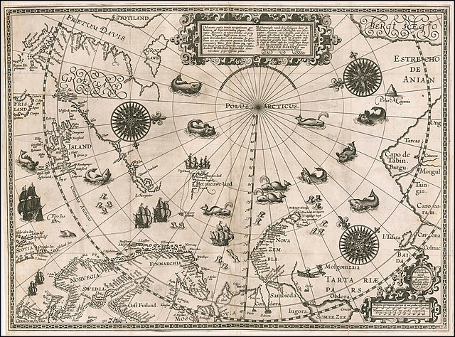
1598 map of the Polar Regions by Willem Barentsz
Summary
edit| Warning | The original file is very high-resolution. It might not load properly or could cause your browser to freeze when opened at full size. |
|---|
| Description |
English: 1598 map of the Polar Regions by Willem Barentsz
Latina: Deliniatio cartae trium navigationum per Batavos, ad Septentrionalem plagam, Norvegiae, Moscoviae, et novae Semblae, et perque fretum Weygatis Nassovicum dictum, ac juxta Groenlandiam, sub altitudine 80. graduum nec non adiacentium partium Tartariae, promontorij Tabin, freti Anian atque regionis Bargi et partis Americae versus orientem, Authore Wilhelmo Bernardo Amstelredamo experissimo pilota.
Nederlands: Beschryvinghe vande drie seylagien door de Hollanders gedaen ande Noordt syde van Noorweghen, Moscovia, nova Sembla, ende door de Weygats ofte Strate de Nassou so mede het' deel van Groenlandt op de 80. graeden ende de omleggende grensen van Tartaryen, ende de Capo de Tabin ende des landtschaps Bargi, so oock het Oostersche deel van America: door Willem Barents van Amstelredam de vermaerde Piloot |
| Date | |
| Source | Barry Lawrence Rare Maps, from an original 1598 print. |
| Author | Original charts by Willem Barentsz, map drawn by Cornelis Claesz ("Cornelius Nicolai"), engraved by Baptista van Doetecum ("Baptista a Doetechum") |
| Other versions |
|
.jpg)

_door_Willem_Barendsz_(titel_op_object),_NG-800.jpg)


Licensing
edit
|
This work is in the public domain in its country of origin and other countries and areas where the copyright term is the author's life plus 70 years or fewer. This work is in the public domain in the United States because it was published (or registered with the U.S. Copyright Office) before January 1, 1929. | |
| This file has been identified as being free of known restrictions under copyright law, including all related and neighboring rights. | |
| Annotations | This image is annotated: View the annotations at Commons |
File history
Click on a date/time to view the file as it appeared at that time.
| Date/Time | Thumbnail | Dimensions | User | Comment | |
|---|---|---|---|---|---|
| current | 18:42, 22 March 2020 | | 13,719 × 10,160 (30.66 MB) | Balkanique (talk | contribs) | Uploaded a work by Willem Barentsz from https://www.raremaps.com/gallery/detail/59238/deliniatio-cartae-trium-navigationum-per-batavos-ad-septent-barentsz with UploadWizard |
You cannot overwrite this file.
File usage on Commons
The following 9 pages use this file:
- Arctic
- File:Barents third voyage.jpg
- File:Barentskartet, 1598 (12068020364).jpg
- File:Barentsz Full Map.jpg
- File:Barentsz arctic map.jpg
- File:Forminsket utgave av Barentskartet - no-nb krt 00487.jpg
- File:Kaart van de landen rond de poolcirkel met de drie reizen van de Nederlanders, 1598 Beschrijvinghe van de drie seylagien door de Hollanders gedaen ande Noordt syde van Noorweghen, Moscovia, nova Sembla, ende door het de, RP-P-OB-80.320.jpg
- File:Kaart van het Noordpoolgebied, 1598 Beschrijvinghe van de drie seylagien door de Hollanders gedaan (..) door Willem Barendsz (titel op object), NG-800.jpg
- File:Pontanus 1611 Arctic Map.jpg
File usage on other wikis
The following other wikis use this file:
- Usage on ar.wikipedia.org
- Usage on ast.wikipedia.org
- Usage on ca.wikipedia.org
- Usage on cs.wikipedia.org
- Usage on da.wikipedia.org
- Usage on de.wikipedia.org
- Usage on en.wikipedia.org
- Usage on es.wikipedia.org
- Usage on fr.wikipedia.org
- Usage on hy.wikipedia.org
- Usage on is.wikipedia.org
- Usage on it.wikipedia.org
- Usage on ja.wikipedia.org
- Usage on la.wikipedia.org
- Usage on nl.wikipedia.org
- Usage on no.wikipedia.org
- Usage on pl.wikipedia.org
- Usage on pt.wikipedia.org
- Usage on sl.wikipedia.org
- Usage on sr.wikipedia.org
- Usage on uk.wikipedia.org
- Usage on vi.wikipedia.org
- Usage on zh.wikipedia.org