File:1600 Block Macleod Trail SW High River abandoned.jpg

Size of this preview: 800 × 450 pixels. Other resolutions: 320 × 180 pixels | 640 × 360 pixels | 1,024 × 576 pixels | 1,280 × 720 pixels | 2,560 × 1,440 pixels | 5,312 × 2,988 pixels.
Original file (5,312 × 2,988 pixels, file size: 5.06 MB, MIME type: image/jpeg)
Captions
Captions
Add a one-line explanation of what this file represents
Summary edit
| Description |
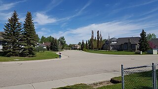
English: Abandoned homes due to 2013 flood in High River, Alberta (1600 Macleod Trail) - slated to be moved. These homes were built on the flood plain in High River, Alberta that in an area that has now been abandoned as per Provincial Government request. The owners were compensated by the Provincial Government. This section of Macleod Trail has now been closed. It included Gascony Lane Road, Beach Way and Saxony Lane Road. |
| Date | |
| Source | Own work |
| Author | Mpeel |
| Camera location | | View this and other nearby images on: OpenStreetMap |
|---|
Licensing edit
I, the copyright holder of this work, hereby publish it under the following license:
This file is licensed under the Creative Commons Attribution-Share Alike 4.0 International license.
- You are free:
- to share – to copy, distribute and transmit the work
- to remix – to adapt the work
- Under the following conditions:
- attribution – You must give appropriate credit, provide a link to the license, and indicate if changes were made. You may do so in any reasonable manner, but not in any way that suggests the licensor endorses you or your use.
- share alike – If you remix, transform, or build upon the material, you must distribute your contributions under the same or compatible license as the original.
File history
Click on a date/time to view the file as it appeared at that time.
| Date/Time | Thumbnail | Dimensions | User | Comment | |
|---|---|---|---|---|---|
| current | 02:21, 23 May 2017 | | 5,312 × 2,988 (5.06 MB) | Mpeel (talk | contribs) | User created page with UploadWizard |
You cannot overwrite this file.
File usage on Commons
There are no pages that use this file.