File:1749 map Chinese Tartary by Tobias Mayer.jpg

Size of this preview: 800 × 517 pixels. Other resolutions: 320 × 207 pixels | 640 × 413 pixels | 1,024 × 662 pixels | 1,280 × 827 pixels | 2,560 × 1,654 pixels | 19,690 × 12,721 pixels.
Original file (19,690 × 12,721 pixels, file size: 45.11 MB, MIME type: image/jpeg)
Captions
Captions
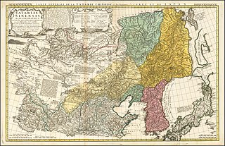
1749 map Chinese Tartary by Tobias Mayer
Summary
edit| Warning | The original file is very high-resolution. It might not load properly or could cause your browser to freeze when opened at full size. |
|---|
| Description |
English: General Map of Chinese Tartary and the Kingdoms of Korea and Japan.
Français : CARTE GENERAL DE LA TARTARIE CHINOISE et des Rojaumes de CORÉE ET DE IAPAN.
Latina: TATARIAE SINENSIS MAPPA GEOGRAPHICA ex Tabulis specialibus R.R.P.P. Iesuitarum nec non Relationibus R.P. Gerbillon per Dom. d'Anville Geographum Parisiensem primum Ao. 1732. nunc secundum L.L. projectionis stereographicae in usum translationis Germanicae Historiae Sinene. Haldianae descripta per Tobiam Mayer, Soc. Cosmogr. Sodal. Curis Homannianorum Heredum. Ao. 1749. |
||||||||||||||||||||
| Date | |||||||||||||||||||||
| Source | https://www.raremaps.com/gallery/detail/53115/tatariae-sinensis-mappa-geographica-ex-tabulis-secialibus-r-mayer | ||||||||||||||||||||
| Author |
|
||||||||||||||||||||
| Other versions |
|
||||||||||||||||||||

.jpg)


.jpg)


Licensing
edit
|
This work is in the public domain in its country of origin and other countries and areas where the copyright term is the author's life plus 70 years or fewer. This work is in the public domain in the United States because it was published (or registered with the U.S. Copyright Office) before January 1, 1929. | |
| This file has been identified as being free of known restrictions under copyright law, including all related and neighboring rights. | |
File history
Click on a date/time to view the file as it appeared at that time.
| Date/Time | Thumbnail | Dimensions | User | Comment | |
|---|---|---|---|---|---|
| current | 07:31, 19 March 2020 | | 19,690 × 12,721 (45.11 MB) | Balkanique (talk | contribs) | Uploaded a work by Tobias Mayer from https://www.raremaps.com/gallery/detail/53115/tatariae-sinensis-mappa-geographica-ex-tabulis-secialibus-r-mayer with UploadWizard |
You cannot overwrite this file.
File usage on Commons
The following 12 pages use this file:
- User:Migebert/Gallery/LKGöttingen/2020 March
- File:Anville Nouvel atlas de la Chine - Page56 Tartarie.jpg
- File:Atlas général de la Chine, de la Tartarie chinoise, et du Tibet - pour servir aux différentes descriptions et histoires de cet empire LOC 00552972-28.jpg
- File:Atlas général de la Chine, de la Tartarie chinoise, et du Tibet - pour servir aux différentes descriptions et histoires de cet empire LOC 00552972-28.tif
- File:Carte générale de la Tartarie Chinoise dressée sur les cartes particulières faites sur les lieux par les RRPP Jésuites et sur les mémoires particuliers du P. Gerbillon - par le Sr. d'Anville... ; Delahaye... - btv1b530527327.jpg
- File:Carte générale de la Tartarie Chinoise dressée sur les cartes particulières faites sur les lieux par les RRPP Jésuites et sur les mémoires particuliers du P. Gerbillon - par le Sr. d'Anville... ; Delahaye... - btv1b531193827.jpg
- File:Carte générale de la Tartarie chinoise... - par le Sr. d'Anville... ; Delahaye sculpsit - btv1b53083581c.jpg
- File:Carte manuscrite de la grande Tartarie contenant le païs entre la Sibérie et la Chine, contenant depuis 35° de latitude à 55° de latitude, en 25 feuilles - btv1b550030640 (01 of 36).jpg
- File:Joseon at its end.jpg
- File:Nouvel Atlas de la Chine, de la Tartarie chinoise et du Thibet contenant les cartes générales et particulières de ces pays, ainsi que la carte du royaume de Corée, la plupart levées sur les lieux... - btv1b53096745m (059 of 117).jpg
- File:Tartariae Sinensis mappa geographica ex Tabulis specialibus RRPP Iesuitarun nec non Relationibus R.P. Gerbillon - per Dom d'Anville... primum A° 1732 nunc se ; Nunc secundum LL. projectionis stereographicae in usum... - btv1b59627203.jpg
- File:Tatariae Sinensis mappa geographica 1749 24374665.jpg