File:1770 map of the Mediterranean Sea by Tobias Conrad Lotter.jpg

Size of this preview: 800 × 329 pixels. Other resolutions: 320 × 132 pixels | 640 × 264 pixels | 1,024 × 422 pixels | 1,280 × 527 pixels | 2,560 × 1,054 pixels | 20,904 × 8,607 pixels.
Original file (20,904 × 8,607 pixels, file size: 28.3 MB, MIME type: image/jpeg)
Captions
Captions
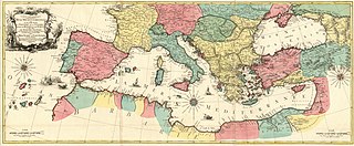
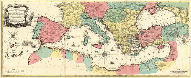
1770 map of the Mediterranean Sea by Tobias Conrad Lotter
Summary edit
| Warning | The original file is very high-resolution. It might not load properly or could cause your browser to freeze when opened at full size. |
|---|
| Description |
English: 1770 map of the Mediterranean Sea by Tobias Conrad Lotter Français : Carte Geographique representant la Mer Mediterranée ou la seconde Partie du Theatre de la Guerre entre les Russes et les Turcs C'est à dire les Roiaumes, les Etâts, les Provinces et les Diverses Isles situées dans la dite Mer, avec la Mer Noire ou Pont Euxine et une Partie de la Province Georgie en Asia / Par Tobie Conrad Lotter Geogr. à Augsbourg |
||||||||||||||||||||||
| Date | |||||||||||||||||||||||
| Source | https://mapy.mzk.cz/de/mzk03/001/053/303/2619316808/ | ||||||||||||||||||||||
| Author |
|
||||||||||||||||||||||
Licensing edit
|
This work is in the public domain in its country of origin and other countries and areas where the copyright term is the author's life plus 70 years or fewer. This work is in the public domain in the United States because it was published (or registered with the U.S. Copyright Office) before January 1, 1929. | |
| This file has been identified as being free of known restrictions under copyright law, including all related and neighboring rights. | |
File history
Click on a date/time to view the file as it appeared at that time.
| Date/Time | Thumbnail | Dimensions | User | Comment | |
|---|---|---|---|---|---|
| current | 20:00, 15 March 2020 | 20,904 × 8,607 (28.3 MB) | Balkanique (talk | contribs) | Uploaded a work by Autor: Lotter, Tobias Conrad, 1717-1777 from https://mapy.mzk.cz/de/mzk03/001/053/303/2619316808/ with UploadWizard |
You cannot overwrite this file.
File usage on Commons
The following 3 pages use this file: