File:1781 CastleWilliams GovernorsIsland BostonHarbor DesBarres.png

Size of this preview: 800 × 215 pixels. Other resolutions: 320 × 86 pixels | 1,017 × 273 pixels.
Original file (1,017 × 273 pixels, file size: 345 KB, MIME type: image/png)
Captions
Captions
Add a one-line explanation of what this file represents
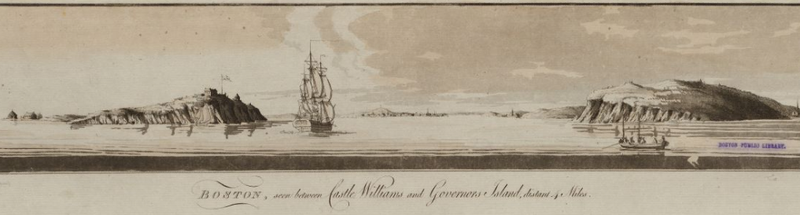
| Description | Boston Harbor, showing Castle Williams and Governors Island |
| Date | |
| Source | Boston Public Library, Norman B. Leventhal Map Center. http://maps.bpl.org |
| Author | Des Barres |
|
This work is in the public domain in its country of origin and other countries and areas where the copyright term is the author's life plus 100 years or fewer. | |
| This file has been identified as being free of known restrictions under copyright law, including all related and neighboring rights. | |
File history
Click on a date/time to view the file as it appeared at that time.
| Date/Time | Thumbnail | Dimensions | User | Comment | |
|---|---|---|---|---|---|
| current | 12:41, 19 October 2009 | 1,017 × 273 (345 KB) | M2545 (talk | contribs) | {{Information |Description=Boston Harbor, showing Castle Williams and Governors Island |Source=Boston Public Library, Norman B. Leventhal Map Center. http://maps.bpl.org |Date=1781 |Author=Des Barres |Permission= |other_versions= }} [[Category:Boston Har |
You cannot overwrite this file.
File usage on Commons
There are no pages that use this file.